AVALANCHE WATCH »
The risk of an avalanche is expected to increase significantly
but the timing and location are still uncertain. Stay tuned for updates.
|
 |
Notice: An Avalanche Watch has been issued for the Bear River range, Wasatch and Central Utah mountains. Avalanche conditions will become increasingly dangerous through Saturday due to strong winds and additional snow. Backcountry users should use caution and avoid travel on and below steep slopes.
An Avalanche Warning has been issued for the western Uinta mountains. See their area specific forecast for details. |
|
|
SPECIAL ANNOUNCEMENT |
 |
On March 11th and 13th, the Utah Avalanche Center and SheJumps will team up to provide a Backcountry 101 class for women only. We will have a Friday night lecture and a Sunday field day to teach youthe basics of how to ski / ride avalanche smart in the Utah backcountry andgive you the confidence and skills to make good decisions for yourself and your group in the backcountry. Details here.
There are just a few lift tickets left - to Sundance, Wolf Mountain and the Canyons ski resorts – 100% of the sale of these donated tickets goes to support the Utah Avalanche Center. |
|
|
BOTTOM LINE
Danger by aspect and elevation on slopes approaching 35° or steeper.
(click HERE for tomorrow's danger rating)
|
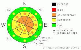
Danger Rose Tutorial
|
With more snow and escalating wind speeds, the avalanche danger will increase to CONSIDERABLE (Level 3) today, with human triggered slides likely and natural avalanches possible on steep, wind drifted slopes. The avalanche danger is increasing to MODERATE (Level 2) on steep, wind sheltered slopes for triggering new snow sluffs and soft slab avalanches as the snow piles up. The danger of triggering an avalanche on a faceted weak layer 2 to 4 feet deep is also increasing as the new snow piles up, especially on wind loaded slopes and in shallower snowpack areas. These are most possible in mid and upper elevation northwest through east through southeast facing terrain, especially along the periphery of the Tri-canyons. |
|
|
CURRENT CONDITIONS |

|
Light to moderate snow is falling in the mountains this morning, with 3 to 9” of new snow in the Salt Lake, Provo and Ogden area mountains. The southwesterly winds have temporarily decreased, with most stations averaging less than 15 mph. Only the highest peaks have averages of 25 mph, with gusts to 35 mph. 10,000’ temperatures are near 10 degrees F. |
|
|
RECENT ACTIVITY |

|
Yesterday, both soft and more stubborn, hard new wind drifts were triggered, some large enough to catch and carry a person. Cornices were sensitive, and dropping off both naturally and with cornice kicks, some triggering new snow soft slabs beneath. There are already reports of sluffing in the new snow this morning. |
|
|
THREAT #1 |

|
| WHERE |
PROBABILITY |
SIZE |
TREND |
|
|
|
|
| |
|
|
Over the next
24 hours.
|
|
|
Yesterday’s strong southwesterly wind event is temporarily over, leaving both soft and hard, stubborn wind drifts scattered along the high ridges and down in the mid terrain. These drifts are now hidden by the new snow, and will be difficult to identify. Many will not be reactive to slope cuts, and could then break above you. The winds are expected to ramp up once again late this afternoon through tonight, increasing the danger by creating more widespread and deeper wind drifts. The large, overhanging cornices are sensitive, and may break back further than expected, and trigger a slide once they drop. If you are dropping or kicking cornices, always have a spotter to make sure there is no one below! |
|
|
THREAT #2 |

|
| WHERE |
PROBABILITY |
SIZE |
TREND |

|
|
|
|
| |
|
|
Over the next
24 hours.
|
|
|
An additional 4 to 8 inches new snow is expected today, and new snow sluffs and shallow soft slabs will become increasingly easy to trigger on steep slopes as the day goes on. The danger will spike any time the snow rates increase to over an inch an hour, and in areas that receives the higher totals. |
|
|
THREAT #3 |

|
| WHERE |
PROBABILITY |
SIZE |
TREND |

|
|
|
|
| |
|
|
Over the next
24 hours.
|
|
|
The deeper faceted weak layers are still lurking beneath, and with another round of snow, the places a person or new snow slide could trigger one of these deeper layers is increasing. It’s a low probability, but the consequences are getting higher as the weak faceted layers are becoming more deeply buried. Any shallow snowpack area or wind loaded areas are the most suspect slopes to trigger one of these deeper slides, particularly along the periphery of the Tri-canyons. |
|
|
MOUNTAIN WEATHER |

|
Impulses from the Pacific coast trough will bring an additional 4 to 8 inches of snow to the northern mountains today on a southwesterly flow. The southwesterly winds will start out the day generally in the 10 to 15 mph range, with the highest peaks averaging 25 mph. However, they will increase this afternoon, reaching average speeds of 30 mph with gusts to 45 across the higher terrain. Temperatures will warm into the upper 20’s at 8,000’. More snow – an additional 4 to 8 inches - and stronger southwesterly winds are in the forecast for tonight, with speeds across the high ridges in the 25 to 35 mph range, with gusts in the 60’s. |
|
|
GENERAL ANNOUNCEMENTS |
|
GENERAL ANNOUNCEMENTS
Skis found - Mt Aire trailhead (Lambs Canyon exit). Call to ID 801-524-5304.
If you trigger an avalanche in the backcountry - especially if you are adjacent to a ski area – please call the following teams to alert them to the slide and whether anyone is missing or not. Rescue teams can be exposed to significant hazard when responding to avalanches, and do not want to do so when unneeded. Thanks.
Salt Lake – Alta Central (801-742-2033)
Ogden – Snowbasin Patrol Dispatch (801-620-1017)
Provo – Sundance Patrol Dispatch (801-223-4150)
Discount Lift tickets: Ski Utah, Backcountry.com, Alta, Deer Valley, Park City, The Canyons, Wolf Mountain, Snowbasin, Beaver Mountain, Brighton, Sundance, and Solitude have donated a limited number of tickets for sale.
Wasatch Powderbird Guides flight plan.
Dawn Patrol Forecast Hotline, updated by 05:30: 888-999-4019 option 8.
Daily observations are frequently posted by 10 pm each evening.
Subscribe to the daily avalanche advisory e-mail click HERE.
UDOT canyon closures UDOT at (801) 975-4838
You have the opportunity to participate in the creation of our own community avalanche advisory by submitting avalanche and snow observations. You can also call us at 801-524-5304 or 800-662-4140, or email by clicking HERE
Donate to your favorite non-profit – The Friends of the Utah Avalanche Center. The UAC depends on contributions from users like you to support our work.
The information in this advisory is from the U.S. Forest Service, which is solely responsible for its content. This advisory describes general avalanche conditions and local variations always occur.
We will update this forecast tomorrow morning. Thanks for calling.
|
|
|
This information does not apply to developed ski areas or highways where avalanche control is normally done. This advisory is from the U.S.D.A. Forest Service, which is solely responsible for its content. This advisory describes general avalanche conditions and local variations always occur. |
|
This advisory provided by the USDA Forest Service, in partnership with:
The Friends of the Utah Avalanche Center, Utah Division of State Parks and Recreation, Utah Division of Emergency Management, Salt Lake County, Salt Lake Unified Fire Authority and the friends of the La Sal Avalanche Center. See our Sponsors Page for a complete list. |
