Salt Lake Avalanche Advisory

Forecaster: Bruce Tremper

SPECIAL ANNOUNCEMENT

The Utah Department of Transportation will attempt to do explosive control on Argenta slidepath in Big Cottonwood Canyon this morning with local closures on the road from 6 am to about 8 am. This was a last minute decision, so it did not make it onto our Dawn Patrol recording (888-999-4019 option 8).

There are still some spots left in the Avalanche 101 class with a Thursday night lecture and a Saturday field day. Click HERE for more details.


BOTTOM LINE

Danger by aspect and elevation on slopes approaching 35° or steeper.
(click HERE for tomorrow's danger rating)


Danger Rose Tutorial

The avalanche danger is mostly Moderate (level 2) today for wind slabs in upper elevation, wind exposed terrain. There are pockets of Considerable (level 3) danger for larger, scary avalanches breaking 2-4 feet deep, especially in shallow snowpack areas, such as outside of the core of the Wasatch Range.


CURRENT CONDITIONS

It was a blustery day yesterday with strong winds from the southwest. Ridge top winds blew 30, gusting to 50. As the winds blew the moist, low-level moisture up the mountains, it created a maelstrom on the upwind side of the high mountains but the rest of the Wasatch Range remained relatively clear. The Logan area mountains received about 8 inches of new snow but only a couple inches in the Wasatch Range.

There is quite a bit of wind damage in the upper elevation wind-exposed terrain. There's sun crusts on anything that faces the south half of the compass and there is still a couple feet of soft, punchy powder on the sun and wind sheltered slopes. It's deep enough that snowmobilers are getting bogged down and trail breaking on skis is still a bit difficult because of a punchy, density inversion so something fat would be the tool of choice.


RECENT ACTIVITY

With people getting into more remote terrain, we received a dozen reports of large, deep avalanches that occured during the storm probably on Sunday. Many of these broke 2-4 feet deep to persistent weak layers near the rain crust from Martin Luther King weekend last month. You can read about many of these on our Current Conditions section.

Yesterday, Brett Kobernik and a couple UDOT forecasters visited the site of a very close call Sunday in the Provo area mountains. See their great report.

Avalanche activity from yesterday was much more tame. Most of the reports we heard about were shallow wind slabs along the upper elevation wind exposed terrain such as in Maybird.


THREAT #1

WHERE PROBABILITY SIZE TREND
      Over the next 24 hours.

We are still worried about triggering deeper, more dangerous, avalanches 2-4 feet deep on buried, persistent weak layers. This danger is much worse in the periphery of the Wasatch Range in shallower snowpack areas. This is the classic, "low probability - high consequence" avalanche situation. Most of the cagy avalanche folks continue to stay on more conservative terrain.


THREAT #2

WHERE PROBABILITY SIZE TREND
      Over the next 24 hours.

The very strong winds yesterday created fresh wind slabs especially in the upper elevation, wind exposed terrain. The winds were from the southwest, but they swirled into many different aspects. Wind slabs are smooth and rounded and often sound hollow or feel slabby. As always, avoid steep slopes with recent wind drifts. These will break out 6 inches to a foot deep and possily deeper in very drifted areas.


THREAT #3

WHERE PROBABILITY SIZE TREND
      Over the next 24 hours.

With clear skies today, expect a few more damp to wet sluffs on the steep, sun exposed slopes.


MOUNTAIN WEATHER

Today will be a rest day between storms with relative light winds, clear skies and warmer temperatues. Ridge top temperatures will be around 20 degrees with a 10-15 mph wind from the southwest.

We have a potentially large storm this weekend starting late Thursday with the main pulse of snow on Friday. We could see a couple more feet of snow, but amounts and timing are uncertain due to the position of the stalled cold front. Be sure to monitor the latest weather forecasts.


GENERAL ANNOUNCEMENTS

If you trigger an avalanche in the backcountry - especially if you are adjacent to a ski area – please call the following teams to alert them to the slide and whether anyone is missing or not. Rescue teams can be exposed to significant hazard when responding to avalanches, and do not want to do so when unneeded. Thanks.

Salt Lake – Alta Central (801-742-2033)

Ogden – Snowbasin Patrol Dispatch (801-620-1017)

Provo – Sundance Patrol Dispatch (801-223-4150)

Discount Lift tickets: Ski Utah, Backcountry.com, Alta, Deer Valley, Park City, The Canyons, Wolf Mountain, Snowbasin, Beaver Mountain, Brighton, Sundance, and Solitude have donated a limited number of tickets for sale.

Wasatch Powderbird Guides flight plan.

Dawn Patrol Forecast Hotline, updated by 05:30: 888-999-4019 option 8.

Daily observations are frequently posted by 10 pm each evening.

Subscribe to the daily avalanche advisory e-mail click HERE.

UDOT canyon closures UDOT at (801) 975-4838

You have the opportunity to participate in the creation of our own community avalanche advisory by submitting avalanche and snow observations. You can also call us at 801-524-5304 or 800-662-4140, or email to uac@utahavalanchecenter.org

Donate to your favorite non-profit – The Friends of the Utah Avalanche Center. The UAC depends on contributions from users like you to support our work.

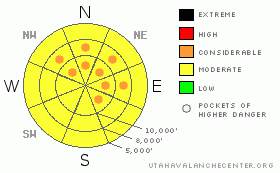
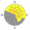
The information in this advisory is from the U.S. Forest Service, which is solely responsible for its content. This advisory describes general avalanche conditions and local variations always occur.

We will update this forecast tomorrow morning. Thanks for calling.


This information does not apply to developed ski areas or highways where avalanche control is normally done.  This advisory is from the U.S.D.A. Forest Service, which is solely responsible for its content. This advisory describes general avalanche conditions and local variations always occur.


This advisory provided by the USDA Forest Service, in partnership with:

The Friends of the Utah Avalanche Center, Utah Division of State Parks and Recreation, Utah Division of Emergency Management, Salt Lake County, Salt Lake Unified Fire Authority and the friends of the La Sal Avalanche Center. See our Sponsors Page for a complete list.