SPECIAL ANNOUNCEMENT |
 |
The FUAC is auctioning off a pair of 176 cm Black Diamond Drift skis with custom Utah Avalanche Center graphics as a fundraiser. Go to Ebay and search for item320647801970 for photos and to bid.
There are just a few lift tickets left - to Sundance, Wolf Mountain and Brianhead ski resorts – 100% of the sale of these donated tickets goes to support the Utah Avalanche Center. |
|
|
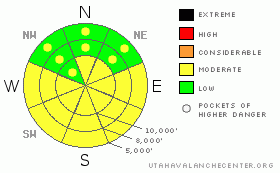
BOTTOM LINE
Danger by aspect and elevation on slopes approaching 35° or steeper.
(click HERE for tomorrow's danger rating)
|
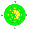
Danger Rose Tutorial
|
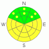
The avalanche danger is Level 2 (Moderate) on mid and upper elevation slopes facing north through southeast, where large avalanches can be triggered in isolated places. The avalanche danger is also a Level 2 (Moderate) for wet sluffs on steep sunny slopes, east through south through west, and on low to mid elevation shady slopes if the snow becomes damp. |
|
|
CURRENT CONDITIONS |

|
The mountains are off to a very warm start this morning, with temperatures at most elevations in the upper twenties to mid thirties. Only the canyon bottoms are cool, in the teens. The winds are from the northwest and generally less than 15 mph, with only a few of the highest peaks gusting to 30. On sheltered, shady slopes the turning and riding is excellent, “loud”, (and getting louder) surface hoar and near surface facets. |
|
|
RECENT ACTIVITY |

|
There were some isolated, but serious avalanches triggered yesterday. In upper Little Cottonwood, explosives released large slides on steep, upper elevation northerly facing terrain, breaking out 2 to 3’ deep and up to 500’ wide, with some on lower angle terrain, all failing on the surface hoar layer buried below the crust.
Down on Cascade Ridge, in the Provo area mountains, something a little different is happening. A slide was remotely triggered, failing on surface hoar above the rain crust, on an east facing slope at 10,000’, a foot deep by 200’ wide, running 1500’ vertical.
And finally, both dry and wet sluffs occurred yesterday on steep slopes.
|
|
|
THREAT #1 |

|
| WHERE |
PROBABILITY |
SIZE |
TREND |
|
|
|
|
| |
|
|
Over the next
24 hours.
|
|
|
Once again, the snowpack is sending mixed messages – many steep lines have been skied, boarded and ridden without incident over the past few days, yet in the exact right spot or with a big enough trigger, large slides can be released, failing on the buried surface hoar (rose of recent surface hoar avalanches). The weak structure is widespread throughout the range – both a buried surface hoar layer and facets below the ice crust. The crust and facets are continuing to weaken in many areas. On most slopes, there is just not enough of a load yet, but in a few isolated places all it would take is the additional weight of a person to trigger a slide.
If you are using snow pit tests for stability analysis, you need to selectively look for weakest areas to dig your pits, because that most represents where you could trigger a slide. When you chose to get into steep terrain, look carefully at the consequences of a mistake – a ride will be much more serious if you go over a cliff, are strained through trees, or dumped into a gully. |
|
|
THREAT #2 |

|
| WHERE |
PROBABILITY |
SIZE |
TREND |
|
|
|
|
| |
|
|
Over the next
10 hours.
|
|
|
A much more widespread, but more predictable issue today will be wet avalanches. With such a warm start to the day, the snow on steep, sunny slopes facing east through south through west will heat rapidly as the sun moves across the sky. Wet sluffs will be easy to trigger, and natural avalanches are possible. Once the snow starts moving, any damp sluff could entrain snow down to crust, so slides could run faster and farther than expected, with big debris piles. In addition, the snow on the shady, northerly facing slopes at the low and mid elevations could also become damp, and human triggered sluffs will be possible. |
|
|
MOUNTAIN WEATHER |

|
It is going to be a sizzler in the mountains today, with 8,000’ temperatures warming into the mid 40’s and 10,000’ temperatures into the mid 30’s. Winds will be variable and very light, less than 10 mph, at most elevations, with only the highest peaks and ridges averaging 15 to 25, with occasional gusts to 35. The high pressure will persist through Saturday. Weak disturbances in a northerly flow will bring cooler air and a few inches of snow late Sunday through Tuesday. |
|
|
GENERAL ANNOUNCEMENTS |
|
If you trigger an avalanche in the backcountry - especially if you are adjacent to a ski area – please call the following teams to alert them to the slide and whether anyone is missing or not. Rescue teams can be exposed to significant hazard when responding to avalanches, and do not want to do so when unneeded. Thanks.
Salt Lake – Alta Central (801-742-2033)
Ogden – Snowbasin Patrol Dispatch (801-620-1017)
Provo – Sundance Patrol Dispatch (801-223-4150)
Discount Lift tickets: Ski Utah, Backcountry.com, Alta, Deer Valley, Park City, The Canyons, Wolf Mountain, Snowbasin, Beaver Mountain, Brighton, Sundance, and Solitude have donated a limited number of tickets for sale.
Wasatch Powderbird Guides flight plan.
Dawn Patrol Forecast Hotline, updated by 05:30: 888-999-4019 option 8.
Daily observations are frequently posted by 10 pm each evening.
Subscribe to the daily avalanche advisory e-mail click HERE.
UDOT canyon closures UDOT at (801) 975-4838
You have the opportunity to participate in the creation of our own community avalanche advisory by submitting avalanche and snow observations. You can also call us at 801-524-5304 or 800-662-4140, or email by clicking HERE
Donate to your favorite non-profit – The Friends of the Utah Avalanche Center. The UAC depends on contributions from users like you to support our work.
The information in this advisory is from the U.S. Forest Service, which is solely responsible for its content. This advisory describes general avalanche conditions and local variations always occur.
We will update this forecast tomorrow morning. Thanks for calling.
|
|
|
This information does not apply to developed ski areas or highways where avalanche control is normally done. This advisory is from the U.S.D.A. Forest Service, which is solely responsible for its content. This advisory describes general avalanche conditions and local variations always occur. |
|
This advisory provided by the USDA Forest Service, in partnership with:
The Friends of the Utah Avalanche Center, Utah Division of State Parks and Recreation, Utah Division of Emergency Management, Salt Lake County, Salt Lake Unified Fire Authority and the friends of the La Sal Avalanche Center. See our Sponsors Page for a complete list. |
