SPECIAL ANNOUNCEMENT |
 |
Discount Lift tickets: There are a few tickets left to Alta, Wolf Mountain, Sundance and Brian Head. Many thanks to Ski Utah, Backcountry.com and all the resorts that participated by donating tickets!
There is still space available in the next Backcountry 101 Avalanche Class. There is an evening session on January 6, with a field day on January 8th. Details at http://utahavalanchecenter.org/education |
|
|
BOTTOM LINE
Danger by aspect and elevation on slopes approaching 35° or steeper.
(click HERE for tomorrow's danger rating)
|
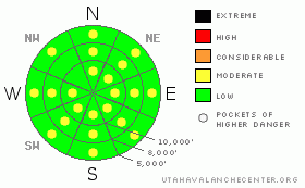
Danger Rose Tutorial
|
The avalanche danger is generally LEVEL 1 (LOW), with pockets of LEVEL 2 (MODERATE) danger for triggering hard wind drifts on steep slopes. There are also pockets of LEVEL 2 (MODERATE) for wet loose avalanches if the snow gets damp on steep, sunny slopes and low elevation shady slopes. |
|
|
CURRENT CONDITIONS |

|
Under clear skies, it is a chilly start to the day, with temperatures in the low teens and single digits this morning. The westerly winds are light, less than 15 mph, except for the highest peaks and the Ogden area ridgelines, which are averaging 25 mph, gusting to 30. Wind sheltered, shady slopes still harbor excellent light powder snow, with the sunny slopes crusted and old wind damage along high ridges and in open bowls. |
|
|
RECENT ACTIVITY |

|
It was another day very quiet day in the backcountry, with no new avalanches reported. However, sightseeing continues, with reports still coming in of large avalanche crowns from the avalanche cycle last week. |
|
|
THREAT #1 |

|
| WHERE |
PROBABILITY |
SIZE |
TREND |

|
|
|
|
| |
|
|
Over the next
24 hours.
|
|
|
It was another day very quiet day in the backcountry, with no new avalanches reported. However, sightseeing continues, with reports still coming in of large avalanche crowns from the avalanche cycle last week. |
|
|
THREAT #2 |

|
| WHERE |
PROBABILITY |
SIZE |
TREND |
|
|
|
|
| |
|
|
Over the next
10 hours.
|
|
|
It will be a clear, sunny morning followed by high, thin clouds moving in. This may be just enough to heat up the surface snow on the steep southeast through westerly facing slopes. Once the snow is damp, it will be possible to trigger loose snow sluffs, and there is still the isolated possibility of a slab releasing, running on the buried sun crust. High thin clouds could even dampen some of the snow on low to mid northerly facing slopes. |
|
|
MOUNTAIN WEATHER |

|
Northern Utah will be under a northwest flow today through Thursday, with weak disturbances bringing occasional cloudy skies and a chance of isolated snow flurries. Clouds will increase this afternoon ahead of the first weak disturbance, and there will be a chance for a snow flurry or two, with accumulations less than an inch. The winds will shift to the northwest, and speeds will gradually increase along the high ridges, into the 20 to 30 mph range, with gusts to 45, late this afternoon through early tomorrow morning. Temperatures will warm into the mid 20’s once again at the 8 to 10,000’ level. The models are now advertizing a strong cold front for Saturday afternoon followed by a cold moist northwest flow that lasts into Monday. |
|
|
GENERAL ANNOUNCEMENTS |
|
If you trigger an avalanche in the backcountry - especially if you are adjacent to a ski area – please call the following teams to alert them to the slide and whether anyone is missing or not. Rescue teams can be exposed to significant hazard when responding to avalanches, and do not want to do so when unneeded. Thanks.
Salt Lake – Alta Central (801-742-2033)
Ogden – Snowbasin Patrol Dispatch (801-620-1017)
Provo – Sundance Patrol Dispatch (801-223-4150)
Wasatch Powderbird Guides flight plan.
Dawn Patrol Forecast Hotline, updated by 05:30: 888-999-4019 option 8.
Daily observations are frequently posted by 10 pm each evening.
Subscribe to the daily avalanche advisory e-mail click HERE.
UDOT canyon closures UDOT at (801) 975-4838
You have the opportunity to participate in the creation of our own community avalanche advisory by submitting avalanche and snow observations. You can also call us at 801-524-5304 or 800-662-4140, or email to uac@utahavalanchecenter.org
Donate to your favorite non-profit – The Friends of the Utah Avalanche Center. The UAC depends on contributions from users like you to support our work.
|
|
|
This information does not apply to developed ski areas or highways where avalanche control is normally done. This advisory is from the U.S.D.A. Forest Service, which is solely responsible for its content. This advisory describes general avalanche conditions and local variations always occur. |
|
This advisory provided by the USDA Forest Service, in partnership with:
The Friends of the Utah Avalanche Center, Utah Division of State Parks and Recreation, Utah Division of Emergency Management, Salt Lake County, Salt Lake Unified Fire Authority and the friends of the La Sal Avalanche Center. See our Sponsors Page for a complete list. |
