SPECIAL ANNOUNCEMENT |
 |
There is still space available in the Backcountry 101 Avalanche Class on January 6 and 8 and the Advanced Avalanche Skills class January 20 and 22. Both classes will have an evening classroom session and a field day. Details at http://utahavalanchecenter.org/education |
|
|
BOTTOM LINE
Danger by aspect and elevation on slopes approaching 35° or steeper.
(click HERE for tomorrow's danger rating)
|
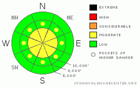
Danger Rose Tutorial
|
The avalanche danger is Level 2 (MODERATE) on steep slopes with recent drifts of windblown snow, which are mainly along the higher ridgelines, and Level 2 for triggering loose sluffs, with long continuously steep terrain increasing their seriousness. The snow may get more sensitive if the sun comes out for a prolong time later today. There is a LEVEL 1 (LOW) danger on wind sheltered slopes less steep than about 35 degrees. |
|
|
CURRENT CONDITIONS |

|
Under partly cloudy skies, we are starting the 2011 year in the icebox, with temperatures around -10 F. Only the Ogden area mountains have readings above zero, in the +5 to -5 range, with the highest ridges at -10 F. Winds are from the southwest to northwest, generally less than 15 mph, but the highest peaks are averaging 20 to 25, with gusts to 30. This puts the wind chill well into the frostbite range of -20 to -35 degree F. As for the snow - Outrageous Utah Powder – nothing else needs to be said. |
|
|
RECENT ACTIVITY |

|
Activity yesterday involved soft slabs triggered on southerly facing Hellgate, 2 feet deep by 40 feet wide, failing on facets above a crust and a small soft slab triggered on Fig 8 Hill behind Brighton, just large enough to briefly catch someone. Explosive control work at the resorts pulled out isolated class 1 and 2 slides, with south and southeast facing slopes most noted. Some of these were new snow only, some down to a crust. In addition, there were easily triggered loose sluffs on steep slopes, some of which were long running, entraining a fair bit of snow. There has been an interesting amount of activity on SE, S, and SW facing slopes the past few days. |
|
|
THREAT #1 |

|
| WHERE |
PROBABILITY |
SIZE |
TREND |

|
|
|
|
| |
|
|
Over the next
12 hours.
|
|
|
The light to moderate winds are continuing to drift the low density snow, and there are sensitive soft to medium stiff wind drifts along the higher ridgelines and in open terrain off ridgelines that will be sensitive to people. These wind drifts are most common on northeast, east and southeasterly facing slopes, and could become more sensitive on steep, sunny slopes if they get a prolonged blast of sun later today. |
|
|
THREAT #2 |

|
| WHERE |
PROBABILITY |
SIZE |
TREND |

|
|
|
|
| |
|
|
Over the next
24 hours.
|
|
|
Respectably large loose snow sluffs are easy to trigger in steep terrain, and could run far, entraining snow, on long, continuously steep slopes and gullies. By late morning or early afternoon, there should be more sun than clouds, and again, that could increase the sensitivity of the snow on the steep, sunny slopes. A larger sluff has the isolated potential to break out a deeper, wider slab avalanche. |
|
|
THREAT #3 |

|
| WHERE |
PROBABILITY |
SIZE |
TREND |

|
|
|
|
| |
|
|
Over the next
24 hours.
|
|
|
This is the monkey business…there are isolated places where more than just the new snow is getting involved in slides. On sunny slopes, it’s an ice crust, with weak snow above or below. On the shady slopes it’s that thin, intermittent rime crust at about the same level, perhaps one of the older density inversions, or a buried old hard wind drift. So if you’re traveling and playing in steep terrain, evaluate each steep slope independently, and travel one at a time. |
|
|
MOUNTAIN WEATHER |

|
It will be another super cold day, with temperatures “warming” to near 10 at 8,000’, and 5 at 10,000’. The winds will gradually become more northwesterly today, and could increase for a few hours this morning, with 20 to 30 mph averages, and gusts in the 30’s. Both the clouds and the winds should decrease this afternoon. Temperatures will gradually warm through mid week as a long term ridge of high pressure moves in. |
|
|
GENERAL ANNOUNCEMENTS |
If you trigger an avalanche in the backcountry - especially if you are adjacent to a ski area – please call the following teams to alert them to the slide and whether anyone is missing or not. Rescue teams can be exposed to significant hazard when responding to avalanches, and do not want to do so when unneeded. Thanks.
Salt Lake – Alta Central (801-742-2033)
Ogden – Snowbasin Patrol Dispatch (801-620-1017)
Provo – Sundance Patrol Dispatch (801-223-4150)
Discount Lift tickets: Ski Utah, Backcountry.com, Alta, Deer Valley, Park City, The Canyons, Wolf Mountain, Snowbasin, Beaver Mountain, Brighton, Sundance, and Solitude have donated a limited number of tickets for sale.
Wasatch Powderbird Guides flight plan.
Dawn Patrol Forecast Hotline, updated by 05:30: 888-999-4019 option 8.
Daily observations are frequently posted by 10 pm each evening.
Subscribe to the daily avalanche advisory e-mail click HERE.
UDOT canyon closures UDOT at (801) 975-4838
You have the opportunity to participate in the creation of our own community avalanche advisory by submitting avalanche and snow observations. You can also call us at 801-524-5304 or 800-662-4140, or email to uac@utahavalanchecenter.org
Donate to your favorite non-profit – The Friends of the Utah Avalanche Center. The UAC depends on contributions from users like you to support our work. |
|
|
This information does not apply to developed ski areas or highways where avalanche control is normally done. This advisory is from the U.S.D.A. Forest Service, which is solely responsible for its content. This advisory describes general avalanche conditions and local variations always occur. |
|
This advisory provided by the USDA Forest Service, in partnership with:
The Friends of the Utah Avalanche Center, Utah Division of State Parks and Recreation, Utah Division of Emergency Management, Salt Lake County, Salt Lake Unified Fire Authority and the friends of the La Sal Avalanche Center. See our Sponsors Page for a complete list. |
