BOTTOM LINE
Danger by aspect and elevation on slopes approaching 35° or steeper.
(click HERE for tomorrow's danger rating)
|
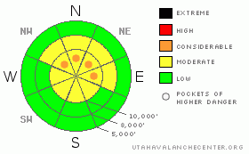
Danger Rose Tutorial
|
The avalanche danger is Level 2 (MODERATE) on any steep slopes with recent drifts of windblown snow. Pockets of Level 3 (CONSIDERABLE) avalanche danger will develop on the most heavily drifted, steepest slopes, and a few natural avalanches are possible. There are also pockets of Level 2 (MODERATE) avalanche danger for a few isolated places where could still trigger a deeper slide, at the higher elevations. |
|
|
CURRENT CONDITIONS |

|
Under partly cloudy skies, it’s been a fairly warm night, with temperatures ranging from the low 20s to mid 30s this morning. The winds have been from a southeasterly direction all night, averaging 20 to 25 mph, with gusts to 40 at times. A few of the highest peaks favored by the southerly flow have averaged 35 to 40 mph, with gusts to 55. Snowshoeing, riding and turning conditions are excellent on wind sheltered slopes in recrystallized powder over a mostly supportable base, with low angle slopes quite good, too. |
|
|
RECENT ACTIVITY |

|
Yesterday, the southeasterly winds increased early than expected, and rapidly created sensitive winds drifts on northwest through easterly facing slopes. Along the Park city ridgeline, a skier triggered a slide in Cinder Chutes and cornice kicks produced two slides in South Monitor. Two people were caught and carried short distances in separate incidents – in Stupid Chute on Wolverine, and in one of the chutes of Wolverine Cirque. Of important note, in this last one, the slide broke well above the person, rather than on any of the several initial ski cuts. All of these slides were about 8 to 12" deep, and up to 100' wide. |
|
|
THREAT #1 |

|
| WHERE |
PROBABILITY |
SIZE |
TREND |
|
|
|
|
| |
|
|
Over the next
12 hours.
|
|
|
While winds speeds have been going up and down the past 12 hours, they have definitely logged enough hours in the 20 to 25 mph range to have continued to drift snow much of the night. These drifts have landed on recrystallized snow of facets and a little surface hoar, part of what is making them so sensitive. With a faceted weak layer, it is possible to trigger them from a distance. Also, at least one of yesterday’s slides was not your soft little wind drift, but a thin, dense hard slab - it had the hard slab characteristic of being stubborn, and breaking out above the person. Today’s drifts will be deeper than yesterday – many in the 1 to 2’ range, and most widespread along the mid and upper elevation, northerly facing ridgelines. But in some areas drifting will have occurred in mid elevation terrain, cross loaded along gully walls or on steep roll overs. |
|
|
THREAT #2 |

|
| WHERE |
PROBABILITY |
SIZE |
TREND |

|
|
|
|
| |
|
|
Over the next
12 hours.
|
|
|
It’s been about 48 hours since the last deeper slides were triggered with explosives, and the trend is definitely for strengthening. However, after such a big storm cycle, with so much activity, I suspect there are still a few spots where a very unlucky person could trigger a deeper slide - high elevation, rocky, hanging snow fields or slopes that have additional recent wind loading. A smaller, wind slab avalanche could also trigger one of these deeper slides. |
|
|
MOUNTAIN WEATHER |

|
A weak storm system will bring light snow to the mountains starting later this afternoon, with 1 to 4 inches of snow possible. Temperatures will be in the low to mid 30’s at 8,000’ and the mid 20’s at 10,000’. The southerly winds will increase slightly, into the 20 to 25 mph range, with gusts to 40, and the high peaks average closer to 35 mph, with gusts to 55. Partly cloudy and cooler on Monday and Tuesday, with a cold, Pacific storm system arriving late Tuesday, which will bring snow through Thursday. |
|
|
GENERAL ANNOUNCEMENTS |
|
If you trigger an avalanche in the backcountry - especially if you are adjacent to a ski area – please call the following teams to alert them to the slide and whether anyone is missing or not. Rescue teams can be exposed to significant hazard when responding to avalanches, and do not want to do so when unneeded. Thanks.
Salt Lake – Alta Central (801-742-2033)
Ogden – Snowbasin Patrol Dispatch (801-620-1017)
Provo – Sundance Patrol Dispatch (801-223-4150)
Discount Lift tickets: Ski Utah, Backcountry.com, Alta, Deer Valley, Park City, The Canyons, Wolf Mountain, Snowbasin, Beaver Mountain, Brighton, Sundance, and Solitude have donated a limited number of tickets for sale.
Wasatch Powderbird Guides flight plan.
Dawn Patrol Forecast Hotline, updated by 05:30: 888-999-4019 option 8.
Daily observations are frequently posted by 10 pm each evening.
Subscribe to the daily avalanche advisory e-mail click HERE.
UDOT canyon closures UDOT at (801) 975-4838
You have the opportunity to participate in the creation of our own community avalanche advisory by submitting avalanche and snow observations. You can also call us at 801-524-5304 or 800-662-4140, or email to uac@utahavalanchecenter.org
Donate to your favorite non-profit – The Friends of the Utah Avalanche Center. The UAC depends on contributions from users like you to support our work. |
|
|
This information does not apply to developed ski areas or highways where avalanche control is normally done. This advisory is from the U.S.D.A. Forest Service, which is solely responsible for its content. This advisory describes general avalanche conditions and local variations always occur. |
|
This advisory provided by the USDA Forest Service, in partnership with:
The Friends of the Utah Avalanche Center, Utah Division of State Parks and Recreation, Utah Division of Emergency Management, Salt Lake County, Salt Lake Unified Fire Authority and the friends of the La Sal Avalanche Center. See our Sponsors Page for a complete list. |
