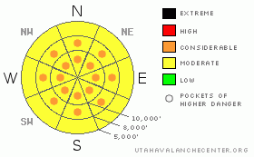
BOTTOM LINE
Danger by aspect and elevation on slopes approaching 35° or steeper.
(click HERE for tomorrow's danger rating)
|
Danger Rose Tutorial
|
Today, the avalanche danger is a solid Level 2 (Moderate) on steep slopes in the mid and upper elevations of Little Cottonwood Canyon where the most snow fell, with pockets of Level 3 (Considerable) danger on any slope with drifts of windblown snow. This danger level applies to anywhere you travel that has about a foot or more of new snow, especially with new wind drifts. Travelers need good route finding skills and good snowpack evaluation skills.
In areas that received less than about 8” of snow, the avalanche danger is generally Level 1 (Low), with pockets of Level 2 (Moderate) danger on steep, wind drifted slopes. |
|
|
CURRENT CONDITIONS |

|
Snow continued to fall on a northwest flow last night, with storm totals in Little Cottonwood in the 14 to 21 inch range. Most other areas received significantly less snow – 6 to 12” in the Provo area mountains, with the Park City side, much of Big Cottonwood and the Ogden area mountains having storm totals in the 4 to 8 inch range. All of this snow is 4 to 5% density fluff. Temperatures are wintery – near zero along the high ridges and in the single digits to low teens at the mid elevations. The northwesterly winds continue to be problematic across the highest terrain, with average speeds of 30 mph, with gusts to 45 mph. Once you get off the high ridges, averages are 10 to 15 mph, with gusts to 30 mph. |
|
|
RECENT ACTIVITY |

|
Yesterday, in the wind effected terrain of the upper Cottonwoods, widespread very shallow (2 - 6” deep) sluffs and soft slabs were easily triggered by people. As the day went on, a few naturals also occurred on heavily wind drifted slopes. I assume there was similar activity in Provo mountains. One party had a hard old cornice break back further than expected. |
|
|
THREAT #1 |

|
| WHERE |
PROBABILITY |
SIZE |
TREND |
|
|
|
|
| |
|
|
Over the next
24 hours.
|
|
|
Sensitive drifts of windblown snow will be the number one concern today, especially in Little Cottonwood and anywhere else that has storm totals of a foot or more of new snow. The steady northwesterly winds have mostly drifted snow onto slopes facing the south ½ of the compass. On many of these slopes, the new snow is poorly bonded to the slick, underlying sun crusts. On these slopes, be prepared for slides to be more easily triggered, break out wider, go faster and further than one would expect, and stack up into decent debris piles.
But also be prepared for wind drifts in other terrain. As always, the terrain channels the wind in all sorts of directions, so approach any steep slope with care, watching for sensitive drifts on all aspects, including on mid elevations, on slope break overs and along the sides of gullies. Winds are forecast to increase once again late this afternoon and tonight, which will increase the avalanche danger.
Delving a bit deeper into the pack, there are pockets of weaker snow in the shallower snow pack areas, including pools of loose faceted graupel and facets beneath the thin sun crusts. A larger slide might be able to break down into one of these deeper layers.
In areas that received less than about 8” of snow, the avalanche danger is generally low, but there will still be pockety, sensitive wind drifts that could be triggered by a person. |
|
|
MOUNTAIN WEATHER |

|
Any lingering snowfall will rapidly diminish today as the storm pulls to the east, and skies should become partly cloudy by midday. Areas favored by northwest flow, such as the upper Little Cottonwood Canyon, could get an additional 2 to 4” of snow this morning, while a trace to 2” is expected elsewhere. Temperatures won’t budge much, warming only into the mid teens at 8,000’ and to near 10 at 10,000. The northwesterly winds will remain in the moderate range for most of the day, averaging 10 to 20 mph, but are forecast to increase significantly late this afternoon and tonight. The high peaks will average near 35 mph, with gusts in excess of 60 mph. Very cold tonight, in the single digits to below zero. Temperatures will warm tomorrow as a ridge builds in, with a slight chance for snow mid week. |
|
|
GENERAL ANNOUNCEMENTS |
GENERAL ANNOUNCEMENTS
Please contact Alta Central (801-742-2033) if you trigger a large avalanche in the backcountry - especially if you are adjacent to a ski area - to alert them to the slide and whether anyone is missing or not. Rescue teams can be exposed to significant hazard when responding to avalanches, and do not want to do so when unneeded. Thanks.
Discount Lift tickets: Ski Utah, Backcountry.com, Alta, Deer Valley, Park City, The Canyons, Wolf Mountain, Snowbasin, Beaver Mountain, Brighton, Sundance, and Solitude have donated a limited number of tickets for sale at discounted prices.
Wasatch Powderbird Guides flight plan.
Dawn Patrol Forecast Hotline, updated by 05:30: 888-999-4019 option 8.
Daily observations are frequently posted by 10 pm each evening.
Free UAC iPhone app from Canyon Sports.
Subscribe to the daily avalanche advisory e-mail click HERE.
UDOT canyon closures UDOT at (801) 975-4838
You can participate in the creation of your own avalanche advisory by submitting your avalanche and snow observations. Or, you can also call us at 801-524-5304 or 800-662-4140. For general email click Contact in the above menu.
Donate to your favorite non-profit – The Friends of the Utah Avalanche Center. The UAC depends on contributions from users like you to support our work.
The information in this advisory is from the U.S. Forest Service, which is solely responsible for its content. This advisory describes general avalanche conditions and local variations always occur.
We will update this forecast tomorrow morning. Thanks for calling. |
|
|
This information does not apply to developed ski areas or highways where avalanche control is normally done. This advisory is from the U.S.D.A. Forest Service, which is solely responsible for its content. This advisory describes general avalanche conditions and local variations always occur. |
|
This advisory provided by the USDA Forest Service, in partnership with:
The Friends of the Utah Avalanche Center, Utah Division of State Parks and Recreation, Utah Division of Emergency Management, Salt Lake County, Salt Lake Unified Fire Authority and the friends of the La Sal Avalanche Center. See our Sponsors Page for a complete list. |
