AVALANCHE WATCH »
The risk of an avalanche is expected to increase significantly
but the timing and location are still uncertain. Stay tuned for updates.
|
 |
Notice:
An Avalanche Watch has been issued for the Wasatch and western Uinta mountains of northern Utah. Periods of heavy snow and strong winds will create increasingly dangerous avalanche conditions today through Tuesday...especially above 8000’. People without avalanche training should avoid backcountry terrain. |
|
|
BOTTOM LINE
Danger by aspect and elevation on slopes approaching 35° or steeper.
(click HERE for tomorrow's danger rating)
|
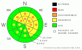
Danger Rose Tutorial
|
The avalanche danger will be increasing today, with pockets of Level 3 (CONSIDERABLE) avalanche danger developing on steep, wind drifted slopes, especially those facing northwest through east, and above about 8,000’. Both new snow wind drifts and deeper slides can be triggered. Out of wind exposed terrain the danger will increase to Level 2 (MODERATE) as the snow piles up later today and tonight. |
|
|
CURRENT CONDITIONS |

|
The first storm has arrived, with the snow falling sideways in the mountains this morning. 1 to 3” dense snow has fallen in the past few hours, with densities around 10%. While many locations have wind speeds averaging 20 to 30 mph, the southwesterly winds are howling along the high ridgelines, with averages to 45 mph and gusts to 70. Temperatures are in the low 20’s to low 30’s. |
|
|
RECENT ACTIVITY |

|
One avalanche was reported from the backcountry yesterday – a stubborn hard slab intentionally triggered in Hidden Canyon, Big Cottonwood Canyon, on a northerly facing slope at 10,000’. Details HERE.
|
|
|
THREAT #1 |

|
| WHERE |
PROBABILITY |
SIZE |
TREND |
|
|
|
|
|
|
New snow numbers aren’t the real issue today - it’s what the winds are doing to that warm, dense snow. They are drifting the snow as fast as it falls, into sensitive piles that can be 2 to 4 times as deep as what’s fallen. 6 inches of new snow = 1 to 2 foot drifts. 12 inches of new snow = 2 to 4 foot drifts. And it’s these drifts that people will be able to trigger on steep slopes. So stay back from corniced ridges, where the cornices can break back further than expected, watch for cracking of the new snow, and use very small test slopes to check the sensitivity of the new wind drifts. Expect to find lots of drifts well off the ridge lines due to the high wind speeds. The snow likes to pile up along the sides of gullies and on mid slope breakovers. |
|
|
THREAT #2 |

|
| WHERE |
PROBABILITY |
SIZE |
TREND |
|
|
|
|
| |
|
|
Over the next
24 hours.
|
|
|
Unfortunately, there are some weak layers buried in our preexisting snow pack, especially on northerly through easterly facing slopes, above about 8,000’. The first layer of concern is weak snow just below the rime/rain crust that formed last Sunday, and this layer is weakest in the shallow snowpack areas, including the Park City ridge line and Ogden area mountains. An avalanche breaking on this layer can be remotely triggered from a distance, and will be wider and deeper than just a new snow slide. There’s lots of variation on individual slopes, in drainages, and throughout the range, which makes forecasting this avalanche problem trickier. |
|
|
MOUNTAIN WEATHER |

|
A strong, moist southwest flow will be over the areas today, with a cold front arriving this evening. 6 to 10 inches of snow is expected today, with densities around 10%. The south to southwesterly winds will continue to increase, with 35 to 45 mph averages common, and gusts in the 60 to 90 mph range. Temperatures will fall during the day, into the 20’s and teens. The winds will shift to the west and decrease late afternoon or early this evening after frontal passage. An additional 8 to 12 inches of snow is possible tonight on a westerly flow. This is just the first in a series of storms that will move across the area through Tuesday, accompanied by periods of high winds. Snow totals by Wednesday could be in the 2 to 4 foot range. |
|
|
GENERAL ANNOUNCEMENTS |
Please contact Alta Central (801-742-2033) if you trigger a large avalanche in the backcountry - especially if you are adjacent to a ski area - to alert them to the slide and whether anyone is missing or not. Rescue teams can be exposed to significant hazard when responding to avalanches, and do not want to do so when unneeded. Thanks.
Soon! Discount Lift tickets: Ski Utah, Backcountry.com, Alta, Deer Valley, Park City, The Canyons, Wolf Mountain, Snowbasin, Beaver Mountain, Brighton, Sundance, and Solitude have donated a limited number of tickets for sale at discounted prices.
Wasatch Powderbird Guides flight plan.
Dawn Patrol Forecast Hotline, updated by 05:30: 888-999-4019 option 8.
Daily observations are frequently posted by 10 pm each evening.
Free UAC iPhone app from Canyon Sports.
Subscribe to the daily avalanche advisory e-mail click HERE.
UDOT canyon closures UDOT at (801) 975-4838
We appreciate all your avalanche and snow observations. You can also call us at 801-524-5304 or 800-662-4140, or email to uac@utahavalanchecenter.org
Donate to your favorite non-profit – The Friends of the Utah Avalanche Center. The UAC depends on contributions from users like you to support our work.
The information in this advisory is from the U.S. Forest Service, which is solely responsible for its content. This advisory describes general avalanche conditions and local variations always occur.
We will update this forecast tomorrow morning. Thanks for calling. |
|
|
This information does not apply to developed ski areas or highways where avalanche control is normally done. This advisory is from the U.S.D.A. Forest Service, which is solely responsible for its content. This advisory describes general avalanche conditions and local variations always occur. |
|
This advisory provided by the USDA Forest Service, in partnership with:
The Friends of the Utah Avalanche Center, Utah Division of State Parks and Recreation, Utah Division of Emergency Management, Salt Lake County, Salt Lake Unified Fire Authority and the friends of the La Sal Avalanche Center. See our Sponsors Page for a complete list. |
