SPECIAL ANNOUNCEMENT |
 |
Bambara Snowstorm Special
Celebrating the onset of winter, first snowfalls and the opening of Utah's ski resorts, executive chef Nathan Powers of the award-winning Bambara, a downtown Kimpton restaurant, has created "Snowstorm" specials to benefit the Utah Avalanche Center. From Monday, November 1 through Friday, November 12, a dollar from each “Snowstorm” special (only $13) will be donated to the Utah Avalanche Center. For more info, find them online. |
|
|
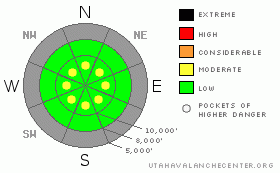
BOTTOM LINE
Danger by aspect and elevation on slopes approaching 35° or steeper.
(click HERE for tomorrow's danger rating)
|
Danger Rose Tutorial
|
The avalanche danger is generally LOW with pockets of MODERATE danger for localized wind drifts along ridgelines and on upper elevation slopes. As always, avoid steep slopes with recent wind deposits. Hitting barely covered rocks is also a significant hazard due to the shallow snowpack. |
|
|
CURRENT CONDITIONS |

|
Under mostly cloudy skies, temperatures are in the mid teens along the high ridges, with low twenties more common in the Ogden mountains and at lower elevations. The winds continue to be from the northwest, averaging less than 10 mph, though overnight gusts reached into the low 20’s at a few exposed locations.
The upper elevation, northerly facing slopes in the Cottonwood Canyons and Provo mountains have up to 3’ of supportable snow on the ground, topped off with excellent light powder. Unfortunately, these good deeper conditions are limited, and the snowpack is still quite thin on southerly facing slopes, in the Ogden mountains, and on mid and low elevation slopes. |
|
|
RECENT ACTIVITY |

|
No avalanches were reported yesterday, though many of us were finding stiff wind drifts along the high ridges that would easily crack. Some of these drifts were also cross loaded off the ridgelines, and would release and slide up to 100' down slope. Cornices could be knocked off in chunks. |
|
|
THREAT #1 |

|
| WHERE |
PROBABILITY |
SIZE |
TREND |

|
|
|
|
| |
|
|
Over the next
24 hours.
|
|
|
Getting surprised by a wind drift in steep or rocky terrain is today’s number one concern. These drifts, or slabs, are hard, cracky, and easy to trigger on steep slopes, and may be just large enough to surprise you. They are right along the ridgelines and also down on to the slopes at the higher elevations, where they are cross loaded around terrain features such as subtle sub ridges or gully walls. The northwesterly winds are forecast to increase this afternoon, so additional drifting of the snow may occur. Along the ridges, a few stubborn cornices could drop off if you get too far out on them. |
|
|
THREAT #2 |

|
| WHERE |
PROBABILITY |
SIZE |
TREND |

|
|
|
|
| |
|
|
Over the next
24 hours.
|
|
|
Out of the wind drifted areas, use normal caution and good travel habits. Replace your beacon batteries and practice searching, and use safe travel habits – go one at a time on steep slopes and find safe places to get out of your partners’ way when you stop. Good travel habits include observing the snowpack. Our shallow snowpack is starting to weaken at the surface, around buried crusts, and near the ground.
Triggering of small loose snow sluffs is again possible today, but only on steep slopes. Most of these sluffs are so small as to be harmless, but watch out if you’re in more radical terrain. |
|
|
MOUNTAIN WEATHER |

|
It will be fairly gray today all the way through Wednesday, as a cool, moist northwesterly flow keeps skies mostly cloudy. Weak weather systems embedded in this flow will bring periods of light snow into Wednesday. Skies will be mostly cloudy today, with a chance for light snow developing this afternoon. The northwesterly winds will average 5 to 15 mph, increasing into the 15 to 25 mph range late morning along the high ridges, with gusts to 40 mph possible. Temperatures will warm to near 20 at 10,000’ and to near 30 at 8,000’. A few inches of snow is possible tonight and again on Sunday. |
|
|
GENERAL ANNOUNCEMENTS |
|
For the Wasatch Powderbird Guides schedule go to their blog
Dawn Patrol Forecast Hotline, updated by 05:30: call 888-999-4019, option 8,
Daily observations are frequently posted by 10 pm each evening.
You can get a free iPhone application from Canyon Sports to display the Bottom Line.
To get a daily avalanche advisory e-mail click HERE.
For a text only version click the upper left link under Search
For canyon closures call UDOT at (801) 975-4838
Send us your avalanche and snow observations. You can also call 801-524-5304 or 800-662-4140, or email to uac@utahavalanchecenter.org
Donate to your favorite non-profit – The Friends of the Utah Avalanche Center. The UAC depends on contributions from users like you to support our work.
We will update this advisory by 7:30 tomorrow morning.
|
|
|
This information does not apply to developed ski areas or highways where avalanche control is normally done. This advisory is from the U.S.D.A. Forest Service, which is solely responsible for its content. This advisory describes general avalanche conditions and local variations always occur. |
|
This advisory provided by the USDA Forest Service, in partnership with:
The Friends of the Utah Avalanche Center, Utah Division of State Parks and Recreation, Utah Division of Emergency Management, Salt Lake County, Salt Lake Unified Fire Authority and the friends of the La Sal Avalanche Center. See our Sponsors Page for a complete list. |
