SPECIAL ANNOUNCEMENT |
 |
Dangerous and tricky avalanche conditions exist. A safe day in the backcountry involves careful route finding, adjusting aspect and slope angles as the snow heats up, safe travel techniques, and well planned exits. While the focus of the natural avalanche activity will be on the steep, sunny slopes, the most likely place for a human triggered slide will be on mid elevation, shady slopes where feathery surface hoar is buried about 2' deep beneath the powder.
|
|
|
BOTTOM LINE
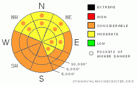
Danger by aspect and elevation on slopes approaching 35° or steeper.
(click HERE for tomorrow's danger rating)
|
Danger Rose Tutorial
|
The avalanche danger for wet slides will rapidly rise from LOW to CONSIDERABLE on east through south through west facing slopes with direct sun and rising temperatures. Natural avalanches are possible, so as the snow heats up, avoid travel on and below steep sunny slopes. Also avoid steep mid and low elevation northerly facing slopes if the snow heats up where you are. There is an overall MODERATE danger on the steep, shady northwest through easterly facing slopes, with pockets of CONSIDERABLE danger for triggering a slide on the buried surface hoar.
|
|
|
CURRENT CONDITIONS |

|
It is a stunning morning, with clear skies and a blanket of fresh, glistening white powder. It was a full on Cottonwoods storm yesterday, with the upper elevations averaging 20”, and mid canyon about 14”. The Park City side received about a foot, while the Ogden and Provo mountains ended up with 6” or less. The southeasterly winds are very light this morning, less than 15 mph at all elevations and temperatures are in the mid teens to mid 20’s. With a sunny, toasty day in store, the only remaining powder by late afternoon will be on the steeper, mid and upper elevation shady slopes.
|
|
|
RECENT ACTIVITY |

|
Yesterday, there were 5 human triggered slides on surface hoar or near surface facets, all at or below about 9000', on north and northeasterly facing slopes. Drainages included Broads Fork, Lambs, Mill B, Mill D, and Big Water. Two small slides released to ground on depth hoar in very shallow snow on a ridgeline and in a rocky area in Broads. Most details are posted. The widespread natural, explosive and human triggered avalanche activity within the new snow peaked in the morning, and rapidly stabilized by afternoon.
|
|
|
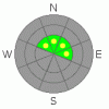
THREAT #1 |

|
| WHERE |
PROBABILITY |
SIZE |
TREND |
|
|
|
|
| |
|
|
Over the next
24 hours.
|
|
|
With the weight of the new snow, the buried surface hoar feathers and near surface facets are active once again. Some slides yesterday were remotely triggered from a distance or not triggered by the first person. Slides averaged 2 feet deep, and ranged from 50’ to 200’ wide. This tricky weak layer is most widespread on mid elevation, north through east facing slopes, and especially widespread in the Mill Creek, Lambs, and mid Big Cottonwood drainages, and north of I-80. There are also some weak crust-facet sandwiches on sunnier slopes as well. Note that in super shallow snowpack areas, slides can break all the way to the ground on another persistent, faceted weak layer - depth hoar.
|
|
|
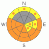
THREAT #2 |

|
| WHERE |
PROBABILITY |
SIZE |
TREND |
|
|
|
|
| |
|
|
Over the next
12 hours.
|
|
|
Direct sun, a 10 degree jump in temperatures and no wind combined with dry, cold powder is a recipe for avalanche activity. Expect possible sun triggered dry slabs on steep east and southeast facing slopes this morning, followed by both wet loose sluffs and possible wet slabs on all steep sunny slopes as the day heats up. Activity will follow the sun - first, east and southeast facing slopes, followed by south and then west. If high thin clouds move in, the low and mid elevation northerly facing slopes will also get damp and reactive. Avoid any steep slope as the snow gets damp, especially where a ride will carry you into trees, off a cliff or into a terrain trap such as a gully or creek bed.
|
|
|
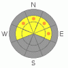
THREAT #3 |

|
| WHERE |
PROBABILITY |
SIZE |
TREND |
|
|
|
|
| |
|
|
Over the next
24 hours.
|
|
|
There may still be a few sensitive wind drifts along the higher ridgelines, and sluffing of the newest snow will be possible on very steep, shady slopes. Kicking cornices and careful slope cuts can reduce much of the danger of these two issues.
|
|
|
MOUNTAIN WEATHER |

|
High pressure will bring clear skies, warm temperatures and light winds to the mountains this morning. The southeasterly winds will average less than 15 mph at all elevations today. Temperatures will rapidly warm to near 40 degrees at 8,000’ and 30 degrees at 10,000’. High thin clouds will move in this afternoon ahead of a very weak system that could give the mountains a few inches of snow on Sunday.
|
|
|
GENERAL ANNOUNCEMENTS |
|
SLC: Please contact Alta Central (801-742-2033) if you trigger a large avalanche in the backcountry, especially if you are adjacent to a ski area, to alert them to the slide and whether anyone is missing or not. Rescue teams can be exposed to significant hazard when responding to avalanches, and do not want to do so when unneeded. Thanks.
Discount Lift tickets: Ski Utah, Backcountry.com, Alta, Deer Valley, Park City, The Canyons, Wolf Mountain, Snowbasin, Beaver Mountain, Brighton, Sundance, and Solitude have donated a limited number of tickets for sale at discounted prices.
Wasatch Powderbird Guides flight plan.
Dawn Patrol Forecast Hotline, updated by 05:30:888-999-4019 option 8.
Daily observations are frequently posted by 10 pm each evening.
Free UAC iPhone app from Canyon Sports.
Subscribe to the daily avalanche advisory e-mail click HERE.
UDOT canyon closures UDOT at (801) 975-4838
We appreciate all your avalanche and snow observations. You can also call us at 801-524-5304 or 800-662-4140, or fill out the observation form on our home page.
Donate to your favorite non-profit – The Friends of the Utah Avalanche Center. The UAC depends on contributions from users like you to support our work.
The information in this advisory is from the U.S. Forest Service, which is solely responsible for its content. This advisory describes general avalanche conditions and local variations always occur.
We will update this forecast tomorrow morning. Thanks for calling.
|
|
|
This information does not apply to developed ski areas or highways where avalanche control is normally done. This advisory is from the U.S.D.A. Forest Service, which is solely responsible for its content. This advisory describes general avalanche conditions and local variations always occur. |
|
This advisory provided by the USDA Forest Service, in partnership with:
The Friends of the Utah Avalanche Center, Utah Division of State Parks and Recreation, Utah Division of Emergency Management, Salt Lake County, Salt Lake Unified Fire Authority and the friends of the La Sal Avalanche Center. See our Sponsors Page for a complete list. |
