BOTTOM LINE
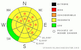
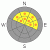
Danger by aspect and elevation on slopes approaching 35° or steeper.
(click HERE for tomorrow's danger rating)
|
Danger Rose Tutorial
|
There are pockets of CONSIDERABLE avalanche danger existing on northwest through north through easterly facing slopes of about 30 degrees and steeper. The danger of triggering a 1-2’ deep, 50 to 100’ wide, soft slab avalanche is most pronounced on the mid and upper elevations of these shady slopes, which are also the same aspects and elevations where there is an isolated possibility of trigging a deeper slide. The danger for wet avalanches may rise to MODERATE on steep sunny slopes and low and mid elevation shady slopes. |
|
|
CURRENT CONDITIONS |

|
Skies are overcast and temperatures this morning in the mid teens to mid twenties, commonly a few degrees warmer than yesterday morning. Winds are from a westerly direction, with all but the highest peaks averaging less than 10 mph. On shady slopes, you’ll be laying tracks through diamond studded powder, while the sunny southeast through westerly facing slopes will be hideously crusted. |
|
|
RECENT ACTIVITY |

|
Ogden area mountains: Widespread collapsing was reported on Cutler Ridge, and explosive work at resorts released hard slabs up to 3' deep and 100' wide on northeast facing upper elevation ridge lines. In the SLC mountains, there were 2 patterns to yesterday’s widespread avalanche activity – slides on the sunny slopes and those on the shady slopes. The most spectacular slides on SE and S facing slopes, involving crusts and surface hoar, were naturals in Cottonwood Draw, 800’ wide, on Cardiac Ridge, which took out the up track, and SE facing Gobblers. Human triggered slides included Two Trees (remote, on the SW side of Cardiff Peak), Dry Fork, and slides in the lower Meadow Chutes breakovers. On northerly facing slopes, there were about 10 human triggered slides, some remotely triggered, mostly about 50’ wide by a foot deep, all failing on surface hoar. Slopes included Georges Bowl, Twin Lakes pass, Pioneer Ridge, Cardiff Bowl, and High Ivory. Slides triggered in Alexander’s Basin and on Mt Aire were up to 150’ wide. I try to have all 15+ slides updated on the Current Conditions page for your lunchtime entertainment… |
|
|
THREAT #1 |

|
| WHERE |
PROBABILITY |
SIZE |
TREND |

|
|
|
|
| |
|
|
Over the next
12 hours.
|
|
|
Talk about being overwhelmed – almost daily there’s a new active weak layer and we’re inundated with avalanches. Today, on shady slopes, people will continue to be able trigger soft slab avalanches, about 50 to 150’ wide, breaking on the buried surface hoar. With surface hoar feathers as the weak layer, slides can be triggered remotely, and involve lower angle slopes than normal. The surface hoar is unusually widespread, at low, mid and upper elevations, on many aspects. Good route finding is essential to avoid a serious accident – be cautious of steeper rollovers or changes in aspect. The consequences of triggering one of these slides will be much more severe if there are trees, cliffs or a terrain trap below you. Also, we may be poised to bury another significant layer of surface hoar - be observant of the snow surface, which was again covered with widespread surface hoar yesterday. |
|
|
THREAT #2 |

|
| WHERE |
PROBABILITY |
SIZE |
TREND |

|
|
|
|
| |
|
|
Over the next
10 hours.
|
|
|
While there should be nothing quite as spectacular as yesterday’s natural avalanche activity, warm temperatures and thinning clouds or some direct sun this afternoon could allow for another smaller round of wet avalanche activity on steep, sunny slopes. And if we get just the right balance of thin clouds, “greenhousing” could heat the snow on the low and mid elevation shady slopes. Switch aspects when the snow becomes damp or the crusts soften. |
|
|
THREAT #3 |

|
| WHERE |
PROBABILITY |
SIZE |
TREND |
|
|
|
|
| |
|
|
Over the next
12 hours.
|
|
|
The deep slab issue is being pushed into the background, but I doubt it’s a thing of the past. Until we get more snow, the most likely spot to trigger a hard slab avalanche near the ground would be a thinner, weak snowpack area, such as steep rocky northerly terrain. In addition, the weak shallow snowpack on slopes that have slid one or more times this year is gradually becoming overloaded to where it could slide once again. |
|
|
MOUNTAIN WEATHER |

|
Skies will be mostly cloudy today, with occasional light snow possible. High temperatures will be in the mid 20’s to mid 30’s. The northwesterly winds will be very light, averaging less than 15 mph. A cold front will push across the area tomorrow, with 5 to 9” of snow possible, with cooling temperatures. A moist, westerly flow for the weekend should produce more snow, and the active pattern could continue next week. |
|
|
GENERAL ANNOUNCEMENTS |
Please contact Alta Central (801-742-2033) if you trigger a large avalanche in the backcountry, especially if you are adjacent to a ski area, to alert them to the slide and whether anyone is missing or not. Rescue teams can be exposed to significant hazard when responding to avalanches, and do not want to do so when unneeded. Thanks.
Discount Lift tickets: Ski Utah, Backcountry.com, Alta, Deer Valley, Park City, The Canyons, Wolf Mountain, Snowbasin, Beaver Mountain, Brighton, Sundance, and Solitude have donated a limited number of tickets for sale at discounted prices.
Wasatch Powderbird Guides flight plan.
Dawn Patrol Forecast Hotline, updated by 05:30:888-999-4019 option 8.
Daily observations are frequently posted by 10 pm each evening.
Free UAC iPhone app from Canyon Sports.
Subscribe to the daily avalanche advisory e-mail click HERE.
UDOT canyon closures UDOT at (801) 975-4838
We appreciate all your avalanche and snow observations. You can also call us at 801-524-5304 or 800-662-4140, or email to uac@utahavalanchecenter.org
Donate to your favorite non-profit – The Friends of the Utah Avalanche Center. The UAC depends on contributions from users like you to support our work.
The information in this advisory is from the U.S. Forest Service, which is solely responsible for its content. This advisory describes general avalanche conditions and local variations always occur.
We will update this forecast tomorrow morning. Thanks for calling. |
|
|
This information does not apply to developed ski areas or highways where avalanche control is normally done. This advisory is from the U.S.D.A. Forest Service, which is solely responsible for its content. This advisory describes general avalanche conditions and local variations always occur. |
|
This advisory provided by the USDA Forest Service, in partnership with:
The Friends of the Utah Avalanche Center, Utah Division of State Parks and Recreation, Utah Division of Emergency Management, Salt Lake County, Salt Lake Unified Fire Authority and the friends of the La Sal Avalanche Center. See our Sponsors Page for a complete list. |
