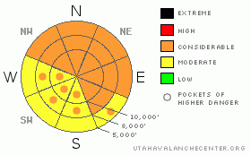
BOTTOM LINE
Danger by aspect and elevation on slopes approaching 35° or steeper.
(click HERE for tomorrow's danger rating)
|
Danger Rose Tutorial
|
The avalanche danger is CONSIDERABLE on all steep slopes, especially those with recent drifts of windblown snow. Very sensitive slides, breaking on surface hoar, can be triggered from a distance, and can release on unusually low angle slopes, of 30 degrees of less. Be aware of the location of other people, so you don’t inadvertently trigger a slide on another group below you. In addition, there remain pockets of CONSIDERABLE danger for triggering a 2 to 4 foot deep, dangerous slab avalanche on the steeper northwest through north through northeast facing slopes at the mid and upper elevations. CONSIDERABLE means dangerous avalanche conditions exist - natural avalanches are possible, and human triggered slides are likely.
|
|
|
CURRENT CONDITIONS |

|
Light snow is just starting to fall in the mountains, and temperatures are in the mid to upper teens above 10,000’. The wind speeds have been significant over the past 24 hours – yesterday from a southwesterly direction, and currently from the northwest. Speeds are fast enough to drift the light, new snow – generally 15 to 20 mph, with gusts to 30, with the higher ridgelines averaging closer to 30 mph, with gusts in the 50’s. Snow totals since Wednesday night are 10” at the higher elevations in the Ogden and Salt Lake mountains, with about ½ that on the Park City side and in the Provo mountains.
|
|
|
RECENT ACTIVITY |

|
The buried surface hoar was very sensitive yesterday. In Mill B South, below 9,000’, there was a remotely triggered soft slab, 6" to 3 feet deep by 200’ wide on a 30 degree slope and in Lambs Canyon an intentionally triggered, 6" deep by 300’ wide soft slab, both were on northeast facing slopes. Last night, a tourer found very sensitive conditions along the Honeycomb ridgeline, with hair trigger releases of the chutes, wall to wall, 6" to 1.5' deep.
|
|
|
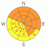
THREAT #1 |

|
| WHERE |
PROBABILITY |
SIZE |
TREND |
|
|
|
|
| |
|
|
Over the next
24 hours.
|
|
|
The new snow has buried a treacherous, persistent weak layer – this time surface hoar feathers on many slopes in the northern Utah mountains, and the new snow will be especially sensitive anywhere the winds have drifted it even a little. Surface hoar slides can release remotely from a distance, on very low angle slopes, and are pockety, so conditions can change over very short distances.
Check out these great video clips showing how sensitive this weak layer is. Here’s a video of Toby’s partner triggering a slide on surface hoar in the Logan mountains yesterday, and Grant’s surface hoar tutorials here.
Even on slopes without buried surface hoar, near surface facets, thin crusts or light new snow will be only slightly less sensitive weak layers beneath the newer snow.
|
|
|
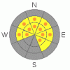
THREAT #2 |

|
| WHERE |
PROBABILITY |
SIZE |
TREND |
|
|
|
|
| |
|
|
Over the next
24 hours.
|
|
|
The migraine inducing weak faceted snow at the bottom of the pack is out of sight, but not out of mind. The added weight of this week’s 5 to 10 inches of snow, drifted by the wind up to 3 feet deep on some slopes, could make it easier once again to trigger a deep slide near the ground. Also, any slide triggered in the new snow could step down, releasing one of these deeper slides. The most likely place for one of these deep slides to break out would be on a steep slope facing northwest through north through northeast, in a thin, rocky snow pack area.
|
|
|
MOUNTAIN WEATHER |

|
Weak disturbances in a moist northwest flow will continue to cross northern Utah today and tonight. For today, periods of light snow should drop another 3 to 6”, especially in areas favored by northwest flow. The winds will remain from the northwest, averaging 10 to 20 mph. However, the higher ridgelines will average closer to 25, and gust into the 50’s. Temperatures will be near 30 at 8,000’, and in the upper teens at 10,000’. A few more inches of snow are possible tonight, with slightly stronger northwesterly winds. Sunday will be partly cloudy and breezy.
|
|
|
GENERAL ANNOUNCEMENTS |
Please contact Alta Central (801-742-2033) if you trigger a large avalanche in the backcountry, especially if you are adjacent to a ski area, to alert them to the slide and whether anyone is missing or not. Rescue teams can be exposed to significant hazard when responding to avalanches, and do not want to do so when unneeded. Thanks.
Discount Lift tickets: Ski Utah, Backcountry.com, Alta, Deer Valley, Park City, The Canyons, Wolf Mountain, Snowbasin, Beaver Mountain, Brighton, Sundance, and Solitude have donated a limited number of tickets for sale at discounted prices.
Wasatch Powderbird Guides flight plan.
Dawn Patrol Forecast Hotline, updated by 05:30:888-999-4019 option 8.
Daily observations are frequently posted by 10 pm each evening.
Free UAC iPhone app from Canyon Sports.
Subscribe to the daily avalanche advisory e-mail click HERE.
UDOT canyon closures UDOT at (801) 975-4838
We appreciate all your avalanche and snow observations. You can also call us at 801-524-5304 or 800-662-4140, or email to uac@utahavalanchecenter.org
Donate to your favorite non-profit – The Friends of the Utah Avalanche Center. The UAC depends on contributions from users like you to support our work.
The information in this advisory is from the U.S. Forest Service, which is solely responsible for its content. This advisory describes general avalanche conditions and local variations always occur.
We will update this forecast tomorrow morning. Thanks for calling.
|
|
|
This information does not apply to developed ski areas or highways where avalanche control is normally done. This advisory is from the U.S.D.A. Forest Service, which is solely responsible for its content. This advisory describes general avalanche conditions and local variations always occur. |
|
This advisory provided by the USDA Forest Service, in partnership with:
The Friends of the Utah Avalanche Center, Utah Division of State Parks and Recreation, Utah Division of Emergency Management, Salt Lake County, Salt Lake Unified Fire Authority and the friends of the La Sal Avalanche Center. See our Sponsors Page for a complete list. |
