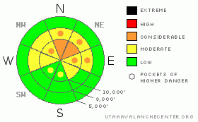
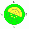
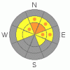
BOTTOM LINE
Danger by aspect and elevation on slopes approaching 35° or steeper.
(click HERE for tomorrow's danger rating)
|
Danger Rose Tutorial
|
The avalanche danger is CONSIDERABLE on slopes approaching 35 degrees or steeper that are wind drifted or have buried layers of weak, faceted snow. These avalanche problems are most widespread on northwest through easterly facing slopes, above about 8,000’, and human triggered avalanches are probable if you jump into some steep, northerly facing shot. Elsewhere, steep slopes have a MODERATE danger.
|
|
|
CURRENT CONDITIONS |

|
Light snow is currently falling this morning, and has added another 1 to 5” of soft fluff above yesterday’s welcome dense snow. Looking at storm totals, the Cottonwoods have averaged 10 to 18”, with upper Big coming in at 28”. The Park City side has 12 to 18” storm totals, the Ogden mountains 10 to 18” and Provo 6”. Temperatures at most mountains stations are within the 15 to 25 degree range. The southeasterly winds are much more civilized this morning, generally less than 15 mph, with a few more favored or exposed locations averaging up to 25 mph. After suffering through months of often poor snow conditions, the current soft turning and riding conditions seem downright sublime.
|
|
|
RECENT ACTIVITY |

|
Yesterday, there was a widespread natural avalanche cycle of smaller, new snow soft slabs failing on a density inversion within new snow. Most were 8-12” deep by 30-100 ft wide, and many were mid slope where the strong winds loaded the snow. There were also several intentionally triggered new snow soft slabs, mostly from cornice kicks or on small test slopes. Both in the backcountry and from resort control work, some deeper slides failed on small facets at the old snow surface from mid January. These were on northwest through easterly facing slopes, in Big Cottonwood, Provo and Park City mountains. Outliers included a natural in the NE chute of Elk Point, probably failing near the ground and a slide failing on facets on a sun crust on a southerly facing slope at 6,000’ in the Ogden mountains. Most are posted, with details and photos, in Current Conditions.
|
|
|
THREAT #1 |

|
| WHERE |
PROBABILITY |
SIZE |
TREND |
|
|
|
|
| |
|
|
Over the next
12 hours.
|
|
|
Yesterday’s density inversion and soft wind drifts should have settled out and strengthened, so they will be less sensitive this morning. Still, avoid the steep wind drifted slopes, which are both along the ridgelines and mid slope. With the southwesterly winds forecast to increase this afternoon and evening, and acres of snow available for transport, wind drifts will become more widespread and sensitive this afternoon.
|
|
|
THREAT #2 |

|
| WHERE |
PROBABILITY |
SIZE |
TREND |
|
|
|
|
| |
|
|
Over the next
12 hours.
|
|
|
Deeper releases are the trickier and more dangerous avalanche problem. So far, these slides have failed on the upper most layer of facets, but the potential exists for failure all the way to the ground, too. Faceted weak layers are notorious for not instantly responding to slope cuts, which means they’ll lure you on to slope, and then the slide will break above you. They can be triggered remotely, so watch what is to the side and above you. Triggering soft cornices or sluffs may not be a big enough punch to trigger one of these deep layers – it may take the weight of a person. Shooting cracks and collapsing are immediate signs of localized instability.
|
|
|
MOUNTAIN WEATHER |

|
A quick little system crossing the area this morning should give the mountains an additional 2 to 4” of low density fluff, before some clearing this afternoon. Temperatures will remain in the mid teens to mid 20’s. The southeasterly winds will shift to the southwest and increase this afternoon, with 10 to 20 mph averages common, and the high ridges averaging to 25, with gusts to 40 mph. This afternoon’s break will be short lived, though, as the next round of snow should begin tonight, lasting through Thursday. Then the main core of the storm should reach northern Utah Friday, bringing snow well into the weekend.
|
|
|
GENERAL ANNOUNCEMENTS |
Discount Lift tickets: Ski Utah, Backcountry.com, Alta, Deer Valley, Park City, The Canyons, Wolf Mountain, Snowbasin, Beaver Mountain, Brighton, Sundance, and Solitude have donated a limited number of tickets for sale at discounted prices.
Wasatch Powderbird Guides flight plan.
Dawn Patrol Forecast Hotline, updated by 05:30:888-999-4019 option 8.
Daily observations are frequently posted by 10 pm each evening.
Free UAC iPhone app from Canyon Sports.
Subscribe to the daily avalanche advisory e-mail click HERE.
UDOT canyon closures UDOT at (801) 975-4838
We appreciate all your avalanche and snow observations. You can also call us at 801-524-5304 or 800-662-4140, or email to uac@utahavalanchecenter.org
Donate to your favorite non-profit – The Friends of the Utah Avalanche Center. The UAC depends on contributions from users like you to support our work.
The information in this advisory is from the U.S. Forest Service, which is solely responsible for its content. This advisory describes general avalanche conditions and local variations always occur.
Brett will update this forecast on Thursday morning. Thanks for calling.
|
|
|
This information does not apply to developed ski areas or highways where avalanche control is normally done. This advisory is from the U.S.D.A. Forest Service, which is solely responsible for its content. This advisory describes general avalanche conditions and local variations always occur. |
|
This advisory provided by the USDA Forest Service, in partnership with:
The Friends of the Utah Avalanche Center, Utah Division of State Parks and Recreation, Utah Division of Emergency Management, Salt Lake County, Salt Lake Unified Fire Authority and the friends of the La Sal Avalanche Center. See our Sponsors Page for a complete list. |
