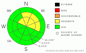
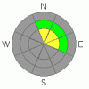
BOTTOM LINE
Danger by aspect and elevation on slopes approaching 35° or steeper.
(click HERE for tomorrow's danger rating)
|
Danger Rose Tutorial
|
The avalanche danger is MODERATE on slopes steeper then 35 degrees especially on northwest through east aspects, especially on slopes with recent deposits of wind drifted snow. This means that human triggered avalanches are possible in localized areas. Continue to follow backcountry protocol by only putting one person in avalanche terrain at a time and clear the runnout zones. (See our Danger Rating Tutorial.) |
|
|
CURRENT CONDITIONS |

|
I have no idea why I woke up at 3 am this morning with such dull conditions. But here I sit in our scenic cubicle at the National Weather Service office near the Airport with the misty, damp fog enveloping the valley. At least the smog blew out yesterday, albiet breifly, as it will quickly build back in today. (bookmark this Air Quality Trend graph)
Meanwhile in the mountains...skies are clear and the cold air has pooled in the bottoms of the mountain valleys, making temperatures plunge down into the single digits. At mid mountain, it's 15 degrees and on the peaks, it's 20 degrees. Winds are moderate from the south and west.
Our poor snow is old and worn out but still provides nice riding on the mid elevation, shady slopes on loud powder (dense, faceted snow). Upper elevations are wind-damaged. In thinner snowpack areas, you often punch through or wallow in a sandbox of faceted, rotted snow. We remain about half of normal snow for this time of year. |
|
|
RECENT ACTIVITY |

|
I have not heard about any avalanche activity from the backcountry yesterday. |
|
|
THREAT #1 |

|
| WHERE |
PROBABILITY |
SIZE |
TREND |
|
|
|
|
| |
|
|
Over the next
24 hours.
|
|
|
Tuesday's wind and a little more yesterday created some localized wind slabs, mostly along the upper elevation ridges so there may still localized places where you can trigger one of these. As usual, you should be suspicious of any steep slope with recent deposits of wind drifted snow, which will look smooth and rounded. |
|
|
THREAT #2 |

|
| WHERE |
PROBABILITY |
SIZE |
TREND |

|
|
|
|
| |
|
|
Over the next
24 hours.
|
|
|
Our snowpit tests still indicate localized areas where you can get both initiation and propagation on the very weak faceted snow at the base of the snowpack. In plain English, this means that it's still possible to trigger an avalanche on some of these slopes. However, with the exception of slopes recently loaded with wind drifted snow, it has been many days since any significant loading has occurred, and the snowpck seems relaxed and dead, with no stored elastic energy. In other words, these slabs are difficult to trigger. |
|
|
MOUNTAIN WEATHER |

|
We have a few more rest days before a major pattern change, which will bring significant storms to the southern half of the U.S., including southern and central Utah. Some of these storms will also give northern Utah some snow and strong southerly winds starting around mid week and again by about next weekend. If these storms come in as advertised, we will experience a major avalanche cycle on our extremely thin and weak snowpack.
In the mean time...we will have mostly clear skies this morning with low and mid level stratus clouds. High clouds should arrive for this afternoon through Saturday. The high today on the ridge tops should be near freezing, the low tonight in the mid 20's and the high on Saturday in the upper 30's. |
|
|
GENERAL ANNOUNCEMENTS |
Discount Lift tickets: Ski Utah, Backcountry.com, Alta, Deer Valley, Park City, The Canyons, Wolf Mountain, Snowbasin, Beaver Mountain, Brighton, Sundance, and Solitude have donated a limited number of tickets for sale at discounted prices.
Wasatch Powderbird Guides flight plan.
Dawn Patrol Forecast Hotline, updated by 05:30:888-999-4019 option 8.
Daily observations are frequently posted by 10 pm each evening.
Free UAC iPhone app from Canyon Sports.
Subscribe to the daily avalanche advisory e-mail click HERE.
UDOT canyon closures UDOT at (801) 975-4838
Send us your avalanche and snow observations. You can also call 801-524-5304 or 800-662-4140, or email to uac@utahavalanchecenter.org
Donate to your favorite non-profit – The Friends of the Utah Avalanche Center. The UAC depends on contributions from users like you to support our work.
The information in this advisory is from the U.S. Forest Service, which is solely responsible for its content. This advisory describes general avalanche conditions and local variations always occur.
Brett will update this forecast tomorrow morning. Thanks for calling. |
|
|
This information does not apply to developed ski areas or highways where avalanche control is normally done. This advisory is from the U.S.D.A. Forest Service, which is solely responsible for its content. This advisory describes general avalanche conditions and local variations always occur. |
|
This advisory provided by the USDA Forest Service, in partnership with:
The Friends of the Utah Avalanche Center, Utah Division of State Parks and Recreation, Utah Division of Emergency Management, Salt Lake County, Salt Lake Unified Fire Authority and the friends of the La Sal Avalanche Center. See our Sponsors Page for a complete list. |
