BOTTOM LINE
Danger by aspect and elevation on slopes approaching 35° or steeper.
(click HERE for tomorrow's danger rating)
|
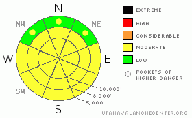
Danger Rose Tutorial
|
This has to be what we'd call an "Experts-Only Moderate". Likelihood? Possible. Size? Varies. Distribution? Spotty and variable. All unmanageable. Previous tracks can be misleading. Consider taking a step back - these are very unusual conditions in the Wasatch. |
|
|
CURRENT CONDITIONS |

|
Skies are clear with temps near freezing along the high ridgelines. Winds are light and variable. Another beautiful day in the hills above the stagnant, cold air in the valleys and basins. |
|
|
RECENT ACTIVITY |

|
Three human triggered slides in the backcountry yesterday. Along Pink Pine, the ridge that separates White Pine and Red Pine gulches, a skier intentionally triggered a shallow soft slab up to a foot deep and 20' wide. A repeater, this northeast facing slope at 8600' ripped out, but not without being preceded by collapsing and cracking in the area.
To the north, along the Park City ridgeline, we heard about two likely hard slabs pulling out on south and southeast facing slopes. We have little information on the second avalanche, but the first took a very experienced skier for a short ride. He approached the slope looking to initiate some wet loose snow and had the hard slab break 4' above him. The slide broke 4-12" deep and 40' wide, failing on a crust facet interface. He was ok. See current conditions for details. The second slide was likely similar in structure, and similar to previous slides triggered along the Park City ridgeline on the 7th and 8th. |
|
|
THREAT #1 |

|
| WHERE |
PROBABILITY |
SIZE |
TREND |
|
|
|
|
| |
|
|
Over the next
24 hours.
|
|
|
Buried surface hoar and weak faceted snow buried on the Tues/Wed storm prior to New Year's continues to produce collapse failures on a variety of aspects and elevations. Collapsing and snow analysis has offered some measure of awareness, but it likely wasn't until the weekend's warm-up that made them more reactive. Kobernik's excellent tutorial on these sunny-side weaknesses provides all one needs to know.
The structure is present - caution is advised on all aspects at the mid and upper elevations for continued sensitivity to human triggers. These may be up to 18" deep and up to 100' wide. |
|
|
THREAT #2 |

|
| WHERE |
PROBABILITY |
SIZE |
TREND |
|
|
|
|
| |
|
|
Over the next
24 hours.
|
|
|
Snow tests continue to provide evidence for unstable snow. It is, however, spatially variable across the range, if not the slope. They are most likely to be triggered on slopes that have previously released and then reloaded - on steep rocky west to north to east facing slopes. More prone areas include the Ogden area mountains, the Park City ridgeline, and Mill Creek. Slopes that did not release seem to be gaining some strength, though it's little consolation - by now which are which? Difficult saying unless you're out most days.
These may be 2-4' deep and up to a couple hundred feet wide. |
|
|
THREAT #3 |

|
| WHERE |
PROBABILITY |
SIZE |
TREND |

|
|
|
|
| |
|
|
Over the next
12 hours.
|
|
|
Plan your exits ahead of time. Wet sluffs will be easy to trigger with daytime warming on all the sun exposed slopes. |
|
|
MOUNTAIN WEATHER |

|
Sunny and clear today with light and variable winds. Temps at 8000' will be in the low 40s. A splitting storm may provide 3-6" Tuesday afternoon into Wednesday. HIgh pressure rebuilds for late week into the weekend. |
|
|
This information does not apply to developed ski areas or highways where avalanche control is normally done. This advisory is from the U.S.D.A. Forest Service, which is solely responsible for its content. This advisory describes general avalanche conditions and local variations always occur. |
|
This advisory provided by the USDA Forest Service, in partnership with:
The Friends of the Utah Avalanche Center, Utah Division of State Parks and Recreation, Utah Division of Emergency Management, Salt Lake County, Salt Lake Unified Fire Authority and the friends of the La Sal Avalanche Center. See our Sponsors Page for a complete list. |
