BOTTOM LINE
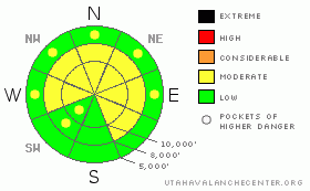
Danger by aspect and elevation on slopes approaching 35° or steeper.
(click HERE for tomorrow's danger rating)
|
Danger Rose Tutorial
|
We’re on the upper end of MODERATE. Naturals are unlikely, but dangerous, unmanageable human triggered avalanches remain possible. These are unusual conditions for the Wasatch. Caution is advised on slopes approaching 35 degrees and steeper on the mid and upper elevation westerly to northerly to easterly aspects. |
|
|
CURRENT CONDITIONS |

|
We have partly cloudy skies and warming temps into the mid 20’s to low 30’s at most mountain stations. The west to northwest winds increased overnight, blowing 25-35mph with gusts to 40 while the sheltered terrain offers little in the way of wind. The wind and sun have carved their slice of the pie and we’re left with the soft recycled powder on the mid elevation shady slopes.
There is a beautiful book, written by the French aviator Antoine de St. Exupery, called Wind, Sand, and Stars. Part of it details a time when his plane crashed in the Libyan desert. I think it was 1935. With little water between them, it wasn’t long until he and his navigator began experiencing visual and auditory hallucinations. Mirages appeared on the landscape, though they were always just out of reach. It’s a little like looking at the weather models these days… |
|
|
RECENT ACTIVITY |

|
More on the avalanche off Miller Hill in the Snowbird periphery from Sunday: two other skiers had ski cut the steep northeast slope at 10,000’, and it wasn’t until the 3rd skier was a little way down the slope that the 2-3’ deep 80’ wide hard slab pulled out. He took a 100’ ride, lost a pole, broke a ski, and did some damage to a knee. Appreciated hearing from him.
To the north along the Cardiac ridge in upper Mill D South of Big Cottonwood, a skier intentionally triggered a warming wind drift 12-18” deep and 15’ wide, though the debris ran 150’. Just on the lee of the Mineral ridgeline, the avalanche released in very steep northeast facing rocky terrain.
Control work in the Ogden area mountains released a 4’ deep hard slab to near the ground…..vigorous collapsing and cracking continues in the Logan mountains and the Western Uintas (see Current Conditions for more info). |
|
|
THREAT #1 |

|
| WHERE |
PROBABILITY |
SIZE |
TREND |

|
|
|
|
| |
|
|
Over the next
24 hours.
|
|
|
Here’s the thing: with avalanching, collapsing, and cracking now the exception and not the rule, you have to pull out the shovel. There’s no other way. I can give you a starting point, but spatial variability within the slow-to-strengthen snowpack is the name of the game. The uppermost problem, the buried patchy surface hoar and weak faceted surface snow formed prior to last Tuesday/Wednesday’s storm is buried 1-2’+ deep. It’s more likely to be triggered in upper elevation wind drifted areas with an easterly component and has the potential be triggered from a distance.
I do believe it’s gaining some strength, but these instabilities are not your bread and butter new snow instabilities. Hard slabs, persistent slabs, and deep slab instabilities are complex and dangerous – it’s what often spells the road for even the savviest of the backcountry. What, then, to say of the beginner/intermediate? |
|
|
THREAT #2 |

|
| WHERE |
PROBABILITY |
SIZE |
TREND |

|
|
|
|
| |
|
|
Over the next
24 hours.
|
|
|
The deep slabs are up to 5’ deep in areas that did not slide during the December 13th cycle. They’re more likely to be triggered in steep rocky terrain that faces north through east. Even simple pole probing into the pack will give an idea of the upside down structure to avoid. |
|
|
MOUNTAIN WEATHER |

|
We’ll have increasing clouds ahead of tomorrow’s disorganized system. With the “storm” riding the ridge, the Ogden and Logan mountains are likely to see 3-6” by Thursday morning. The central and southern Wasatch perhaps trace to 2. Winds will be west to northwest at 15-20 along the high ridgelines, though they’ll trend toward 30-35mph tonight. Temps will be in the upper 20s. Clearing skies follow for Thursday/Friday with another mirage on the horizon for the weekend. It should be noted for history that de St. Exupery survived his ordeal in the desert. |
|
|
GENERAL ANNOUNCEMENTS |
Discount Lift tickets: Ski Utah, Backcountry.com, Alta, Deer Valley, Park City, The Canyons, Wolf Mountain, Snowbasin, Beaver Mountain, Brighton, Sundance, and Solitude have donated a limited number of tickets for sale at discounted prices.
Wasatch Powderbird Guides flight plan.
Dawn Patrol Forecast Hotline, updated by 05:30:888-999-4019 option 8.
Daily observations are frequently posted by 10 pm each evening.
Free UAC iPhone app from Canyon Sports.
Subscribe to the daily avalanche advisory e-mail click HERE.
UDOT canyon closures UDOT at (801) 975-4838
Send us your avalanche and snow observations. You can also call 801-524-5304 or 800-662-4140, or email to uac@utahavalanchecenter.org
Donate to your favorite non-profit – The Friends of the Utah Avalanche Center. The UAC depends on contributions from users like you to support our work.
The information in this advisory is from the U.S. Forest Service, which is solely responsible for its content. This advisory describes general avalanche conditions and local variations always occur.
Evelyn will update this forecast on Wednesday morning. Thanks for calling. |
|
|
This information does not apply to developed ski areas or highways where avalanche control is normally done. This advisory is from the U.S.D.A. Forest Service, which is solely responsible for its content. This advisory describes general avalanche conditions and local variations always occur. |
|
This advisory provided by the USDA Forest Service, in partnership with:
The Friends of the Utah Avalanche Center, Utah Division of State Parks and Recreation, Utah Division of Emergency Management, Salt Lake County, Salt Lake Unified Fire Authority and the friends of the La Sal Avalanche Center. See our Sponsors Page for a complete list. |
