BOTTOM LINE
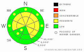
Danger by aspect and elevation on slopes approaching 35° or steeper.
(click HERE for tomorrow's danger rating)
|

Danger Rose Tutorial
|
We’re on the upper end of MODERATE. Naturals are unlikely, but dangerous, unmanageable human triggered avalanches remain possible. These are unusual conditions for the Wasatch. Caution is advised on slopes approaching 35 degrees and steeper on the mid and upper elevation westerly to northerly to easterly aspects. |
|
|
CURRENT CONDITIONS |

|
Skies are clear with west to northwest winds blowing 15-20 along the high ridgelines. Overnight lows above 9000’ continue to warm into the upper teens and low twenties. Cooler air pooling from the drainages has temps there in the upper single digits. Riding conditions remain excellent in sheltered terrain. |
|
|
RECENT ACTIVITY |

|
The string of activity continued into yesterday, with at least two skier triggered slides in the backcountry. In the Provo mountains, a skier remotely triggered a pocket 1’ deep and 30’ wide, running well over 300’ on an east facing slope at 9900’. No collapsing or cracking or movement from other tracks preceded the activity. To the north in the Snowbird periphery, a skier triggered a 2’+ pocket that was 80’ wide, also running over 300’. It was on a steep, rocky, windloaded pocket in northerly terrain at about 10,000’. Check under the Current Conditions tab for photos -
Collapsing continues to be reported on a variety of aspects and elevations. |
|
|
THREAT #1 |

|
| WHERE |
PROBABILITY |
SIZE |
TREND |

|
|
|
|
| |
|
|
Over the next
24 hours.
|
|
|
The plot thickens with the current snowpack. It’s an exceedingly complex animal, varying significantly across the range. Our two major concerns stem from the basal weak depth hoar from November, and the weak surface snow and patchy surface hoar from before last Wednesday’s storm. Both have been players.
The newest persistent weakness is more widely distributed on a variety of aspects and elevations. They are more likely triggered in exposed, wind drifted areas, or, due to the higher accumulations on New Year’s Eve, the terrain north of I-80. Collapsing and cracking will not always be present and the spatial variability of snowpits may not necessarily offer red flags. Still, the volatile structure remains. Those without significant experience and detective work are rolling the dice. |
|
|
THREAT #2 |

|
| WHERE |
PROBABILITY |
SIZE |
TREND |

|
|
|
|
| |
|
|
Over the next
24 hours.
|
|
|
Deep slab instabilities remain, particularly in areas that released during the December 13th cycle. These instabilities, spread across the westerly to northerly to easterly aspects, appear more pronounced outside of the upper elevations of the Cottonwoods and Provo mountains. Again, significant experience and detective work is required. |
|
|
MOUNTAIN WEATHER |

|
We’ll have partly cloudy skies today and tonight until with a disorganized Pacific disturbance denting the building ridge tomorrow into Wednesday. Temps will rise to the upper 20s at 10,000’ and the mid 30s at 8000’. The west to northwest winds will be 10-15mph. The ridge redevelops for the end of the week and into the weekend with the longer range models suggesting a less than impressive system for perhaps late Saturday into Sunday. |
|
|
GENERAL ANNOUNCEMENTS |
|
Discount Lift tickets: Ski Utah, Backcountry.com, Alta, Deer Valley, Park City, The Canyons, Wolf Mountain, Snowbasin, Beaver Mountain, Brighton, Sundance, and Solitude have donated a limited number of tickets for sale at discounted prices.
Wasatch Powderbird Guides flight plan.
Dawn Patrol Forecast Hotline, updated by 05:30:888-999-4019 option 8.
Daily observations are frequently posted by 10 pm each evening.
Free UAC iPhone app from Canyon Sports.
Subscribe to the daily avalanche advisory e-mail click HERE.
UDOT canyon closures UDOT at (801) 975-4838
Send us your avalanche and snow observations. You can also call 801-524-5304 or 800-662-4140, or email to uac@utahavalanchecenter.org
Donate to your favorite non-profit – The Friends of the Utah Avalanche Center. The UAC depends on contributions from users like you to support our work.
The information in this advisory is from the U.S. Forest Service, which is solely responsible for its content. This advisory describes general avalanche conditions and local variations always occur.
I will update this forecast on Tuesday morning. Thanks for calling. |
|
|
This information does not apply to developed ski areas or highways where avalanche control is normally done. This advisory is from the U.S.D.A. Forest Service, which is solely responsible for its content. This advisory describes general avalanche conditions and local variations always occur. |
|
This advisory provided by the USDA Forest Service, in partnership with:
The Friends of the Utah Avalanche Center, Utah Division of State Parks and Recreation, Utah Division of Emergency Management, Salt Lake County, Salt Lake Unified Fire Authority and the friends of the La Sal Avalanche Center. See our Sponsors Page for a complete list. |

