SPECIAL ANNOUNCEMENT |
 |
Happy Solstice -
For your Holiday Shopping, consider purchasing some of Our Ski Area Lift Tickets as stocking stuffers or give the gift of a donation to your favorite charity, the Friends of the Utah Avalanche Center. |
|
|
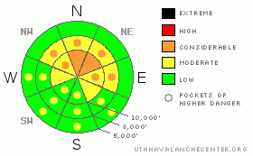
BOTTOM LINE
Danger by aspect and elevation on slopes approaching 35° or steeper.
(click HERE for tomorrow's danger rating)
|
Danger Rose Tutorial
|
DANGEROUS AVALANCHE CONDITIONS STILL EXIST. The avalanche danger remains CONSIDERABLE on mid and upper elevation northwest through east facing slopes approaching 35 degrees or steeper, where people can trigger avalanches to the ground. These are unmanageable conditions - Difficult to forecast, dangerous to ski or slope cut, and not going away anytime soon.
Watch for recent wind slabs and pillows on north through east aspects, as these may be sitting right on top of a trigger point for a deep slab avalanche. Avoid the steep terrain, where it is very difficult to tell the difference between stable and unstable slopes. With daytime heating, the avalanche danger will rise to MODERATE on the steep, sunny slopes. |
|
|
CURRENT CONDITIONS |

|
Despite the winds from last night cold air still remains in mountain valleys and lower elevations reading in the teens. Temperatures at mid and upper elevations are in the mid 20’s. Winds picked up last night for several hours from the southwest, averaging in the 20’s with gusts above 40 at ridge tops. Snow surfaces on north aspects are mostly recycled powder with any surface hoar that may have survived the overnight winds. South aspects still sport stout crusts that will likely soften through the day. |
|
|
RECENT ACTIVITY |

|
Only one new slide was reported from yesterday, which likely took out old tracks. This was in north facing Upper Days fork around 10,200’ and was triggered by a cornice drop, 40’ wide, 2.5’ deep and running 150’. Minor collapsing was also reported yesterday. |
|
|
THREAT #1 |

|
| WHERE |
PROBABILITY |
SIZE |
TREND |

|
|
|
|
| |
|
|
Over the next
24 hours.
|
|
|
The main concern for today remains at the deep buried layer of weak facets overlaid by a one meter or so strengthening slab. Reflected by the danger rating, this problem continues to persist. Chances are one can trigger one of these hidden dragons with no sign of cracking, collapsing or other sign of instability. Ski or sled tracks offer little measure of reliable information. Furthermore, few - prudently - have pushed the envelope in steep radical northerly terrain. The lack of activity may also reflect this fact.
Those that have pushed into the steeper terrain have a significant amount of experience and looking at what terrain has released adn what has not. Where are the old crowns and flanks? How much of the faceted snow remains? Is there a new slab above this - or not? One must put the work into these decisions... |
|
|
THREAT #2 |

|
| WHERE |
PROBABILITY |
SIZE |
TREND |

|
|
|
|
| |
|
|
Over the next
24 hours.
|
|
|
Well, it was looking like things were going to get a little bit less sensitive today, however, the winds from last night have put a stop to that. Winds drifts are expected to have formed on north through east aspects. The new drifts are likely to be very sensitive on the steeper slopes and most pronounced in the upper elevation north through east facing slopes. Remotely triggered drifts are possible, as they were likely drifted on some exceedingly weak faceted snow and/or surface hoar. |
|
|
THREAT #3 |

|
| WHERE |
PROBABILITY |
SIZE |
TREND |

|
|
|
|
| |
|
|
Over the next
10 hours.
|
|
|
The third issue for the day is wet avalanches. With partly cloudy skies the sun has a good chance to warm the snow surface producing small but heavy wet slides. |
|
|
MOUNTAIN WEATHER |

|
Clear skies should give way to increasing clouds in the afternoon ahead of tomorrow's storm. Winds today will be west to southwesterly in the 15-20mph range. 8000' and 10,000' temps will rise to 40 and the upper 20's, respectively. The broad, moist Pacific storm will start to produce snow tomorrrow morning, with snow continuing throughout the day. 8-14" expected in favored areas. A ridge develops for the latter part of the week. |
|
|
GENERAL ANNOUNCEMENTS |
Discount Lift tickets: Ski Utah, Backcountry.com, Alta, Deer Valley, Park City, The Canyons, Wolf Mountain, Snowbasin, Beaver Mountain, Brighton, Sundance, and Solitude have donated a limited number of tickets for sale at discounted prices.
For the Wasatch Powderbird Guides schedule go to their blog
Dawn Patrol Forecast Hotline, updated by 05:30: call 888-999-4019, option 8,
Daily observations are frequently posted by 10 pm each evening.
You can get a free iPhone application from Canyon Sports to display the Bottom Line.
To get a daily avalanche advisory e-mail click HERE.
For a text only version click the upper left link under Search
For canyon closures call UDOT at (801) 975-4838
Send us your avalanche and snow observations. You can also call 801-524-5304 or 800-662-4140, or email to uac@utahavalanchecenter.org
Donate to your favorite non-profit – The Friends of the Utah Avalanche Center. The UAC depends on contributions from users like you to support our work.
The information in this advisory is from the U.S. Forest Service, which is solely responsible for its content. This advisory describes general avalanche conditions and local variations always occur.
I will update this forecast tomorrow morning. Thanks for calling. |
|
|
This information does not apply to developed ski areas or highways where avalanche control is normally done. This advisory is from the U.S.D.A. Forest Service, which is solely responsible for its content. This advisory describes general avalanche conditions and local variations always occur. |
|
This advisory provided by the USDA Forest Service, in partnership with:
The Friends of the Utah Avalanche Center, Utah Division of State Parks and Recreation, Utah Division of Emergency Management, Salt Lake County, Salt Lake Unified Fire Authority and the friends of the La Sal Avalanche Center. See our Sponsors Page for a complete list. |
