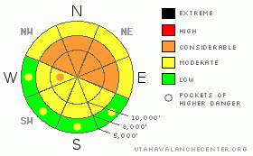
BOTTOM LINE
Danger by aspect and elevation on slopes approaching 35° or steeper.
(click HERE for tomorrow's danger rating)
|
Danger Rose Tutorial
|
DANGEROUS AVALANCHE CONDITIONS STILL EXIST. The avalanche danger remains CONSIDERABLE (Level 3) on mid and upper elevation northwest through east facing slopes approaching 35 degrees or steeper, where people can trigger avalanches to the ground. Avoid the steep terrain, where it is very difficult to tell the difference between stable and unstable slopes. Instead, be patient – there are 4 more months of winter left! Take advantage of and enjoy the good turning and riding conditions on shady lower angle, gentle terrain. With daytime heating, the avalanche danger will rise to MODERATE on the steep, sunny slopes.
|
|
|
CURRENT CONDITIONS |

|
Above the dreary smog, it’s a beautiful, clear morning in the mountains. Temperatures are mostly in the teens, with single digits in the canyon bottoms. The northwesterly wind speeds are generally less than 10 mph, though the highest peaks are gusting into the low 20’s. Soft snow remains on the shady northwest through northeasterly facing slopes, with the sunny slopes sporting stout crusts that will soften with daytime heating.
|
|
|
RECENT ACTIVITY |

|
There was only one reported avalanche yesterday - an intentionally triggered slide with a cornice drop in Main Days – NE facing, about 10,000’, 70 to 150’ wide, breaking out to the ground on facets, and running about 1000’ vertical. In addition, the Cottonwood resorts released some slides to the ground with explosives, north and northeasterly facing, above 9,000’. Collapsing is much less frequent, but still reported yesterday from the Cottonwoods and Park City ridgeline.
|
|
|
THREAT #1 |

|
| WHERE |
PROBABILITY |
SIZE |
TREND |
|
|
|
|
| |
|
|
Over the next
24 hours.
|
|
|
It’s like a frustrating bad dream that just goes a on and on - unstable conditions that won’t end. Mid and upper elevation northwest through east facing slopes have extremely weak, faceted snow on the ground which is not gaining strength even though the last storm ended days ago, and it’s very difficult to tell which slopes are stable and which slopes might slide. Some of the slopes that slid during the storm have filled back in with wind drifted snow been triggered by people. Normally, cracking and collapsing are warning signs, but may not be present anymore. Experience, conservative decision making and excellent route finding skills are essential for travel in and around the steep, shady terrain today. Watch your elevations, slope angles and aspects carefully. The take home point: there are many slopes that can still be triggered by the weight of a person, and if you trigger a slide, it will probably go to the ground, 2 to 4’ deep, 100+ feet wide, big enough to smash you into trees or rocks and bury you. Slopes can be released from a distance, breakout above you on the3rd turn, or on the 4th person on the slope.
|
|
|
THREAT #2 |

|
| WHERE |
PROBABILITY |
SIZE |
TREND |

|
|
|
|
| |
|
|
Over the next
10 hours.
|
|
|
Lots of sunshine and warm temperatures will heat the shallow snowpack on southeast through westerly facing slopes and at low elevations today. In steep terrain, it will become possible to trigger wet, loose sluffs at the low and mid elevations.
|
|
|
MOUNTAIN WEATHER |

|
High pressure will strengthen today and dominate through the weekend. Skies will be mostly clear, with occasional high thin clouds moving through. 8,000’ temperatures will warm back into the low 30’s and 10,000’ highs will be in the 20’s. The northwesterly winds will remain light, generally less than 15 mph, with the highest terrain having gusts to 30 mph. Sunday will be even warmer. Then skies will become cloudy on Monday, with a chance for snow Monday night into Tuesday.
|
|
|
GENERAL ANNOUNCEMENTS |
Discount Lift tickets: Ski Utah, Backcountry.com, Alta, Deer Valley, Park City, The Canyons, Wolf Mountain, Snowbasin, Beaver Mountain, Brighton, Sundance, and Solitude have donated a limited number of tickets for sale at discounted prices.
For the Wasatch Powderbird Guides schedule go to their blog
Dawn Patrol Forecast Hotline, updated by 05:30: call 888-999-4019, option 8,
Daily observations are frequently posted by 10 pm each evening.
You can get a free iPhone application from Canyon Sports to display the Bottom Line.
To get a daily avalanche advisory e-mail click HERE.
For a text only version click the upper left link under Search
For canyon closures call UDOT at (801) 975-4838
Send us your avalanche and snow observations. You can also call 801-524-5304 or 800-662-4140, or email to uac@utahavalanchecenter.org
Donate to your favorite non-profit – The Friends of the Utah Avalanche Center. The UAC depends on contributions from users like you to support our work.
The information in this advisory is from the U.S. Forest Service, which is solely responsible for its content. This advisory describes general avalanche conditions and local variations always occur.
Brett Kobernik will update this forecast on Sunday morning. Thanks for calling.
|
|
|
This information does not apply to developed ski areas or highways where avalanche control is normally done. This advisory is from the U.S.D.A. Forest Service, which is solely responsible for its content. This advisory describes general avalanche conditions and local variations always occur. |
|
This advisory provided by the USDA Forest Service, in partnership with:
The Friends of the Utah Avalanche Center, Utah Division of State Parks and Recreation, Utah Division of Emergency Management, Salt Lake County, Salt Lake Unified Fire Authority and the friends of the La Sal Avalanche Center. See our Sponsors Page for a complete list. |
