BOTTOM LINE
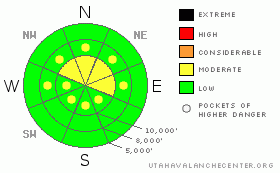
Danger by aspect and elevation on slopes approaching 35° or steeper.
(click HERE for tomorrow's danger rating)
|
Danger Rose Tutorial
|
A MODERATE danger exists for human triggered soft slabs primarily in the upper elevation north through east facing wind affected areas. The steepest slopes will be prone to human initiated sluffing in the low density snow. If more wind arrives than expected, the danger will rise to CONSIDERABLE. Caution is advised for the powder starved as we teeter on the edge of the house of cards we call our pre-existing snowpack. |
|
|
CURRENT CONDITIONS |

|
With the center of the storm moving to the east, cold, moist, unstable air fills in the wake. Most of the range has already picked up an additional 4-6”, and storm totals now sit at about 6-10” in the Cottonwoods, and the Ogden and Park City mountains. Provo canyon provided the arena for the perfect storm of colliding warm and cold air masses, and they literally watched 16” of snow fall before their very eyes. Totals in this microclimate now add up to nearly 2’ and 1.5” of snow-water-equivalent.
Colder air from the northwest has pushed the thermometers down into the single digits and below. The winds, while gusting into the 30’s yesterday, are now mercifully light from the west and northwest. |
|
|
RECENT ACTIVITY |

|
Those poking into the upper elevation lee terrain found sensitive, shallow wind drifts driven by the stronger southwesterly winds. They ranged from 3-8” deep and 20’ wide. One skier took a short ride, but escaped unharmed. The outlier, along the eastern portion of the Park City ridgeline, may be a portent of things to come. A skier triggered a sluff that gouged 1 to 1.5’ deep and 60’ onto the old facet/basal crust interface. It was on a northeast facing slope at 9000’.
With it snowing 1, 2, 3 and 4 inches per hour in Provo Canyon, numerous heretofore grassy slopes sluffed naturally on slopes steeper than 35 degrees. Poor visibility limited the observations of anything higher along the crests of Timpanogos and the Cascade ridgeline. |
|
|
THREAT #1 |

|
| WHERE |
PROBABILITY |
SIZE |
TREND |

|
|
|
|
| |
|
|
Over the next
24 hours.
|
|
|
I will be greatly interested in what people find today. Those travelling in terrain out of yesterday’s wind affected areas should find little slab development with sluffing the main cause for caution. It may be possible for sluffs to gouge into the older weak faceted snow, particularly in the mid elevation west to north to easterly facing aspects. |
|
|
THREAT #2 |

|
| WHERE |
PROBABILITY |
SIZE |
TREND |

|
|
|
|
| |
|
|
Over the next
24 hours.
|
|
|
More of the wildcard centers on the wind drifted areas. On one hand, the newly falling snow is falling right side up with little accompanying wind. On the other hand, it may be possible to collapse some of yesterday’s drifts onto the weak faceted snow found in the upper elevation north through easterly aspects. It’ll be important to jump onto test slopes, listen for any collapsing, and poke around in the snow prior to center-punching the more open exposed lines. Remember that all of yesterday’s drifts will be covered by now – terrain should be considered suspect until proved otherwise. |
|
|
MOUNTAIN WEATHER |

|
We can expect continued light snowfall with some chance of lake-enhancement this afternoon. 4-8” additional inches may be expected, with more in favored areas. The west to northwest winds are expected to remain less than about 15mph as temperatures spiral down below zero. We’ll get a bit of a break mid-week with moist westerlies on the way for Friday into the weekend. |
|
|
GENERAL ANNOUNCEMENTS |
Our web site is now formatted for iPhone. You can also download a free iPhone application from Canyon Sports to display the Bottom Line. Search for Utah Avalanche on the Apple's iPhone Apps page or in iTunes.
If you want to get this avalanche advisory e-mailed to you daily click HERE.
For a text only version, the link is on the left side bar, near the top.
UDOT highway avalanche control work info can be found by calling (801) 975-4838. Our statewide toll free line is 1-888-999-4019 (early morning, option 8).
Donate to your favorite non-profit – The Friends of the Utah Avalanche Center. The UAC depends on contributions from users like you to support our work. To find out more about how you can support our efforts to continue providing the avalanche forecasting and education that you expect please visitour Friends page.
We appreciate avalanche and snow observations. If there’s something we should know about give us a call at (801) 524-5304 or 1-800-662-4140, or email us at uac@utahavalanchecenter.org. (Fax 801-524-6301).
We will update this forecast Wednesday morning. And thanks for calling. |
|
|
This information does not apply to developed ski areas or highways where avalanche control is normally done. This advisory is from the U.S.D.A. Forest Service, which is solely responsible for its content. This advisory describes general avalanche conditions and local variations always occur. |
|
This advisory provided by the USDA Forest Service, in partnership with:
The Friends of the Utah Avalanche Center, Utah Division of State Parks and Recreation, Utah Division of Emergency Management, Salt Lake County, Salt Lake Unified Fire Authority and the friends of the La Sal Avalanche Center. See our Sponsors Page for a complete list. |
