SPECIAL ANNOUNCEMENT |
 |
Lots of events taking place this week: (more info on all these and more on our Calendar/Upcoming events page)
Join the Utah Avalanche Center - Logan for their annual Pray For Snow party at the Italian Place in Logan tomorrow (Wednesday)night at 6:30pm. It's a great community event, fundraiser, and party all rolled into one.
Canyon Sports in Cottonwood will be hosting their 2nd Annual BREW*SKI, a ski season kick off party to benefit the Friends of the Utah Avalanche Center Friday night starting at 5pm. Music, raffles, food and drink, and more.
And coming to Park City Friday night: Flakes: the newest Powderwhores movie is coming to Harry O's. Doors open at 7pm. Cost is $10 with live music after the show. All proceeds benefit the Friends of the Utah Avalanche Center. |
|
|
BOTTOM LINE
Danger by aspect and elevation on slopes approaching 35° or steeper.
(click HERE for tomorrow's danger rating)
|
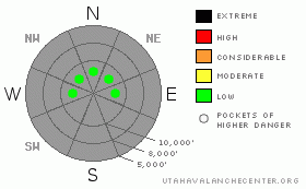
Danger Rose Tutorial
|
The overall danger is LOW. Perhaps even pockets of LOW. One may get some tired, shallow wind drifts to crack out, but they'd pose little danger. |
|
|
CURRENT CONDITIONS |

|
Skies are clear with mountain temps in the mid teens to low twenties. The west to northwest winds kicked up a bit overnight ahead of today's weak cold dry front. (Yes this was a typo, but seems apropos...) They're blowing in the 15-20mph range with some gusts near 40. One to two feet of snow covers the shady aspects, hosting a complement of stiff and stubborn over-the-handlebars wind slabs, breakeable wind and suncrusts, patches of recycled powder, and unsupportable snow in the sandbox. Did I mention the breaching rocks and stumps? My partner yesterday remarked that insead of 'earning our turns', we were suffering the turns to earn the exercise. |
|
|
RECENT ACTIVITY |

|
Some minor cracking a couple days ago in the tired wind slabs from last Friday. They'll crack and shear out above the weak faceted snow in isolated terrain. See photo gallery. Folks are submitting some excellent obs, photos, and pit profiles. Don't forget to check the latest submissions in our Current Conditions page, found in the upper left hand corner. |
|
|
THREAT #1 |

|
| WHERE |
PROBABILITY |
SIZE |
TREND |
|
|
|
|
| |
|
|
Over the next
24 hours.
|
|
|
More thoughts from my field day here. Shallow snow means weak snow and high pressure/sunny days does not mean that nothing is going on in the snowpack. The clear skies and relatively cold nights drive the temperature gradients throughout the pack, commonly found at the snow surface, at layer interfaces (such as a rain or hard crust), and at the base of the pack. This in turn, drives the snow to form into weak, sugary, cohesionless grains. They tend to look 'gray", feel crystalline, and have little cohesive strength. Some of these layers of "faceted snow" are so loose they tend to fall out of the snowpit wall upon excavation. Pull out your shovel and you'll see what I mean. |
|
|
MOUNTAIN WEATHER |

|
A change is gonna come. Dry cold air pushing in from the north will plunge temps to the mid to low teens and into the single digits tomorrow into Thursday. The Logan area mountains may tease a flurry or two out of a weak storm grazing to the north tomorrow, but otherwise we'll be high and dry through the week. Winds will be from the northwest blowing 20-25mph. The weather models each bring a different solution to the table for the weekend - and while I'm not willinng to be the farm on anything - the critical element is that none of them advertise the dominant ridge of high pressure. |
|
|
GENERAL ANNOUNCEMENTS |
We'll update this advisory by Thursday.
Our web site is now formatted for iPhone. You can also download a free iPhone application from Canyon Sports to display the Bottom Line. Search for Utah Avalanche on the Apple's iPhone Apps page or in iTunes.
If you want to get this avalanche advisory e-mailed to you daily click HERE.
For a text only version, the link is on the left side bar, near the top.
UDOT highway avalanche control work info can be found by calling (801) 975-4838. Our statewide toll free line is 1-888-999-4019 (early morning, option 8).
Donate to your favorite non-profit – The Friends of the Utah Avalanche Center. The UAC depends on contributions from users like you to support our work. To find out more about how you can support our efforts to continue providing the avalanche forecasting and education that you expect please visitour Friends page.
We appreciate avalanche and snow observations. If there’s something we should know about give us a call at (801) 524-5304 or 1-800-662-4140, or email us at uac@utahavalanchecenter.org. (Fax 801-524-6301). Or submit an observation from the link in the upper left hand menu of the page. |
|
|
This information does not apply to developed ski areas or highways where avalanche control is normally done. This advisory is from the U.S.D.A. Forest Service, which is solely responsible for its content. This advisory describes general avalanche conditions and local variations always occur. |
|
This advisory provided by the USDA Forest Service, in partnership with:
The Friends of the Utah Avalanche Center, Utah Division of State Parks and Recreation, Utah Division of Emergency Management, Salt Lake County, Salt Lake Unified Fire Authority and the friends of the La Sal Avalanche Center. See our Sponsors Page for a complete list. |
