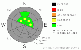
BOTTOM LINE
Danger by aspect and elevation on slopes approaching 35° or steeper.
(click HERE for tomorrow's danger rating)
|
Danger Rose Tutorial
|
The avalanche danger is mostly LOW with pockets of MODERATE danger on any slope approaching 35 degrees or steeper with recent deposits of wind drifted snow. |
|
|
CURRENT CONDITIONS |

|
Winds have increased along the ridges with 11,000’ winds blowing 30, gusting to 50 from the south southwest. Down at 10,000’ they are 20, gusting to 40. Temperatures are warm, close to and above freezing. The snowpack is a skimpy 2' deep on upper elevation, north facing slopes, about a foot deep below 8,500' and nonexistent on south facing slopes. Although you can actually find some nice, recrystallized snow that feels like powder on the shady, north facing slopes, the rocks lurk only inches below, so fear and caution are healthy attributes these days. |
|
|
RECENT ACTIVITY |

|
No activity from yesterday, but with the stronger winds today we will need to be on the lookout for wind slabs. |
|
|
THREAT #1 |

|
| WHERE |
PROBABILITY |
SIZE |
TREND |
|
|
|
|
| |
|
|
Over the next
24 hours.
|
|
|
Wind is the word of the day. The approaching, weak, cold front has kicked up the winds from the south and southwest, which usually would spell big problems with an extremely tender, pre-existing snowpack we have. Except that there is almost no snow on south facing slopes, so there is nothing to blow around. So the main problem will be cross loading from strong winds, mostly along the upper elevation ridges, mainly on east and west facing slopes in wind exposed areas. Remember that the old snow is extremely weak pile of faceted snow and it will not take much weight to dangerously overload it.
As always, avoid any steep slopes with recent wind deposits. These will look smooth and rounded and often sound hollow like a drum. They can range from soft to hard snow. |
|
|
MOUNTAIN WEATHER |

|
We have a poor excuse of a storm for tonight and Saturday, which is splitting apart as it approaches and will give us mostly a few clouds, and if we’re lucky a skiff of snow. Meanwhile it is stirring up the wind today from the southwest, which will blow 30, gusting to 50 on the highest peaks and 20, gusting to 40 along most ridges. Temperatures will remain warm today, near 40 degrees, but they will drop on Saturday to freezing and into the mid teens by Saturday night.
Then, everything warms up again for the rest of the weak with another poor-looking storm diving south of us a week from now. Things continue to look grim. |
|
|
GENERAL ANNOUNCEMENTS |
Envision Utah is looking for input on the “Wasatch Canyons Tomorrow” update of the County's 1989 Plan, in partnership with Salt Lake City, the State of Utah and the US Forest Service. There is an online survey “Wasatch Canyons Tomorrow” at http://www.envisionutah.org/index.html .
We will issue or next forecast Friday morning. Our web site is now formatted for iPhone. You can also download a free iPhone application from Canyon Sports to display the Bottom Line. Search for Utah Avalanche on the Apple's iPhone Apps page or in iTunes.
If you want to get this avalanche advisory e-mailed to you daily click HERE.
For a text only version, the link is on the left side bar, near the top.
UDOT highway avalanche control work info can be found by calling (801) 975-4838. Our statewide toll free line is 1-888-999-4019 (early morning, option 8).
Donate to your favorite non-profit – The Friends of the Utah Avalanche Center. The UAC depends on contributions from users like you to support our work. To find out more about how you can support our efforts to continue providing the avalanche forecasting and education that you expect please visitour Friends page.
We appreciate avalanche and snow observations. If there’s something we should know about give us a call at (801) 524-5304 or 1-800-662-4140, or email us at uac@utahavalanchecenter.org. (Fax 801-524-6301).
The information in this advisory is from the U.S. Forest Service, which is solely responsible for its content. This advisory describes general avalanche conditions and local variations always occur. |
|
|
This information does not apply to developed ski areas or highways where avalanche control is normally done. This advisory is from the U.S.D.A. Forest Service, which is solely responsible for its content. This advisory describes general avalanche conditions and local variations always occur. |
|
This advisory provided by the USDA Forest Service, in partnership with:
The Friends of the Utah Avalanche Center, Utah Division of State Parks and Recreation, Utah Division of Emergency Management, Salt Lake County, Salt Lake Unified Fire Authority and the friends of the La Sal Avalanche Center. See our Sponsors Page for a complete list. |
