SPECIAL ANNOUNCEMENT |
 |
This forecast will cover two days – today, Wednesday and Thursday, Thanksgiving Day. We will issue morning forecasts again Friday through the weekend, as wind and snow in the forecast may make the avalanche conditions slightly more interesting and hazardous.
|
|
|
BOTTOM LINE
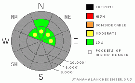
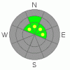
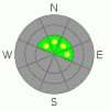
Danger by aspect and elevation on slopes approaching 35° or steeper.
(click HERE for tomorrow's danger rating)
|
Danger Rose Tutorial
|
The avalanche danger is mostly LOW today and tomorrow, with pockets of MODERATE danger on steep slopes for both dry and damp sluffs, and for isolated places where it may be possible to trigger a soft new wind drift. There are also very isolated places at upper elevation terrain where it may be possible to trigger an old, hard wind drift on facets. |
|
|
CURRENT CONDITIONS |

|
This morning, under clear skies, temperatures are in the upper teens to mid twenties, with the cooler readings in the canyon bottoms. Winds are from the northwest, and are nudging 15 to 20 mph speeds across the higher ridgelines. Good turning and riding conditions exist in shallow powder on isolated slopes – those upper elevation northeast through northwesterly facing slopes, where there is a smooth ground cover beneath, with two feet or more of snow on top. Granted, it is rather limited acreage, and the real catch is to avoid a season ending encounter with a rock, especially on the exits.
|
|
|
RECENT ACTIVITY |
|
|
|
THREAT #1 |

|
| WHERE |
PROBABILITY |
SIZE |
TREND |
|
|
|
|
| |
|
|
Over the next
36 hours.
|
|
|
Today and tomorrow, sluffing of the surface snow will be the most common type of avalanche. On cold, shady slopes, shallow, dry loose sluffs may be triggered in steep terrain. On slopes with an easterly or westerly component that catch some sun, a few damp sluffs may occur with heating from the sun and warming temperatures. While these will be small, remember that even a small slide could knock you off balance, and push you into the widespread rocks.
Wind speeds are forecast to remain less than 20 mph until Thursday night, but if you are in an area where they pick up, they will rapidly drift the light powder snow into sensitive, soft shallow drifts. This would be along the higher ridgelines, and as always avoid wind drifts on steep slopes.
|
|
|
THREAT #2 |

|
| WHERE |
PROBABILITY |
SIZE |
TREND |
|
|
|
|
| |
|
|
Over the next
36 hours.
|
|
|
Field work shows widespread layers of weak, sugary facets on the shady slopes that have little prospect of strengthening, and a future avalanche cycle on these layers is becoming inevitable. Yesterday’s collapse and the slide triggered remotely in the Logan area mountains Monday show it will not take much more weight to trigger a slide on one of the weak faceted layers. Undoubtedly, there is somewhere in the Wasatch mountains where a deeper slide could be triggered now, and travelers choosing very steep, wind drifted shady upper elevation terrain should be extra cautious or consider taking the lower angle options for travel both up and down. This includes traveling or climbing the high peaks in Provo area mountains.
|
|
|
MOUNTAIN WEATHER |

|
High pressure will strengthen and remain across northern Utah through Thursday, with a strong warming trend for the mountains. Highs temperatures at both 8 and 10,000’ will be in the upper 30’s today and in the low 40’s on Thanksgiving. The northerly winds will generally be less than 15 mph today, and remain light on Thursday as they shift to the southeast and then southwest. Two small storms are expected to move through the Great Basin Friday night through early Sunday, but unfortunately, at the moment, moisture seems to be lacking with both pieces.
|
|
|
This information does not apply to developed ski areas or highways where avalanche control is normally done. This advisory is from the U.S.D.A. Forest Service, which is solely responsible for its content. This advisory describes general avalanche conditions and local variations always occur. |
|
This advisory provided by the USDA Forest Service, in partnership with:
The Friends of the Utah Avalanche Center, Utah Division of State Parks and Recreation, Utah Division of Emergency Management, Salt Lake County, Salt Lake Unified Fire Authority and the friends of the La Sal Avalanche Center. See our Sponsors Page for a complete list. |
