SPECIAL ANNOUNCEMENT |
 |
UDOT will close the Little Cottonwood Canyon road between the Town of Alta and Gate B at 6:30 a.m. this morning to test fire military artillery. Inter-lodge Travel restrictions, implemented by the Alta Marshall, and Snowbird Snow Safety, will go into effect at 7:00 a.m. It is anticipated that the road will reopen by 7:45 a.m.
White Pine in Park City will host an Avalanche Awareness gathering at 6pm tonight at the Park City Library Jim Santy Auditorium in Park City). It is a Donation requested event to benefit the Friends of the Utah Avalanche Center. Hope to see you there. For more info, click here or go to our home page and look under the Calendar of Events.
Much of Alta will be closed to uphill traffic as they prep for opening day. Access to Grizzly Gulch and Supreme will still be open via the Summer Road. Remember that the closed ski areas aren't conducting avalanche control and all your 'known' terrain has a backcountry snowpack. |
|
|
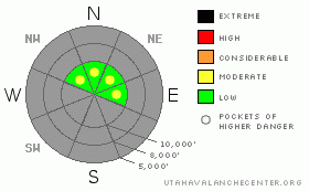
BOTTOM LINE
Danger by aspect and elevation on slopes approaching 35° or steeper.
(click HERE for tomorrow's danger rating)
|
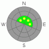
Danger Rose Tutorial
|
Pockets of MODERATE danger exist with the most recent storm snow. Watch for continued sluffing on the steepest shady aspects as well as any new super soft wind drift development from the higher overnight gusts. They'd be more pronounced just off the ridgelines on slopes facing northeast through southeast. Collapsing and cracking are good clues for local instabilities. |
|
|
CURRENT CONDITIONS |

|
I went up into upper Little Cottonwood yesterday to verify my forecast and it didn't take long to figure out that I had overestimated the wind effect and had completely blown the forecast. In this business you don't have to wait long to be humbled. The consolation prize, of course, turned out to be excellent skiing and riding conditions - perhaps the best of the year.
Skies are clear under a building ridge of high pressure and temperatures reflect the stagnancy of the atmosphere: upper air temps continue to rise through the night into the upper teens while the basins and drainages suffer the single digits. Winds, beyond a couple hours of gusts into the upper 30's overnight, are generally less than 15-20mph. |
|
|
RECENT ACTIVITY |

|
Those on the steepest slopes reported easy to initiate loose snow avalanches in the 6-8% density snow. One minor collapse produced localized stress cracks just off the ridge, and we heard that an experienced skier had a very soft slab 10" deep and 20' wide break out 20' above him. It was off the PC ridgeline on a steep northeast facing slope at 9700'. He was oblivious to the release as It followed him all the way down the slope, nipping at his heels, but it didn't pack much of a punch. In the Central Wasatch, there just wasn't enough of a load or slab formation to affect the increasingly weak faceted coverage that we call our snowpack.
The LOGAN AREA mountains clearly headline the activity from yesterday. Our forecaster up there Toby Weed found the conditions I was forecasting: he collapsed the slope and remotely triggered a 2' deep and 300' wide soft slab. His gallery can be found here. |
|
|
THREAT #1 |

|
| WHERE |
PROBABILITY |
SIZE |
TREND |
|
|
|
|
| |
|
|
Over the next
24 hours.
|
|
|
The hazard for today centers on the continued sluffing in the new snow, new super soft slab development along the highest northeast to southeast facing slopes, and the potential for remotely triggered releases. The very low density snow may drift easily with anything but a whisper of wind: watch for and avoid any pockety wind pillows in the highest, lee terrain. |
|
|
MOUNTAIN WEATHER |

|
We'll have clear skies, light winds, and mountain temps in the mid to upper 20's. The ridge of high pressure builds throught the week and each day will be a carbon copy of the previous day. The models suggest a change for the weekend, but are in disagreement on the details. |
|
|
GENERAL ANNOUNCEMENTS |
Envision Utah is looking for input on the “Wasatch Canyons Tomorrow” update of the County's 1989 Plan, in partnership with Salt Lake City, the State of Utah and the US Forest Service. There is an online survey “Wasatch Canyons Tomorrow” at http://www.envisionutah.org/index.html .
We will be issuing intermittent morning or afternoon avalanche advisories as conditions change.
Our web site is now formatted for iPhone. You can also download a free iPhone application from Canyon Sports to display the Bottom Line. Search for Utah Avalanche on the Apple's iPhone Apps page or in iTunes.
If you want to get this avalanche advisory e-mailed to you daily click HERE.
For a text only version, the link is on the left side bar, near the top.
UDOT highway avalanche control work info can be found by calling (801) 975-4838. Our statewide toll free line is 1-888-999-4019 (early morning, option 8).
Donate to your favorite non-profit – The Friends of the Utah Avalanche Center. The UAC depends on contributions from users like you to support our work. To find out more about how you can support our efforts to continue providing the avalanche forecasting and education that you expect please visitour Friends page.
We appreciate avalanche and snow observations. If there’s something we should know about give us a call at (801) 524-5304 or 1-800-662-4140, or email us at uac@utahavalanchecenter.org. (Fax 801-524-6301). |
|
|
This information does not apply to developed ski areas or highways where avalanche control is normally done. This advisory is from the U.S.D.A. Forest Service, which is solely responsible for its content. This advisory describes general avalanche conditions and local variations always occur. |
|
This advisory provided by the USDA Forest Service, in partnership with:
The Friends of the Utah Avalanche Center, Utah Division of State Parks and Recreation, Utah Division of Emergency Management, Salt Lake County, Salt Lake Unified Fire Authority and the friends of the La Sal Avalanche Center. See our Sponsors Page for a complete list. |
