SPECIAL ANNOUNCEMENT |
 |
Much of Alta will be closed to uphill traffic as they prep for opening day. Access to Grizzly Gulch and Supreme will still be open via the Summer Road. Remember that the closed ski areas aren't conducting avalanche control and all your 'known' terrain has a backcountry snowpack. |
|
|
BOTTOM LINE
Danger by aspect and elevation on slopes approaching 35° or steeper.
(click HERE for tomorrow's danger rating)
|

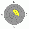
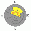
Danger Rose Tutorial
|
Pockets of CONSIDERABLE danger exist in the high northwest through northeast to east facing slopes steeper than 35 degrees. This is confined to the upper reaches of the Cottonwoods and relegated to the shady aspects that had pre-existing snow. Human triggered slides are likely and may be triggered remotely from lower angled slopes onto the steeper slopes above or adjacent to you. Outside of this admittedly small piece of real-estate, the overall danger is MODERATE for sensitive wind drifts just off the ridgelines. The Ogden and Provo mountains have an overall LOW danger. |
|
|
CURRENT CONDITIONS |

|
A powerful storm swept through the Wasatch front in the evening spreading 4-6" outside of the Central Wasatch and 8-10" in the upper reaches of the Cottonwoods. Densities average 6-8%, and while I was looking for snow with a little more meat on its bones, this'll have to do. The last few flakes will fall with sunrise and things should clear out as the storm moves rapidly east. Winds burst with frontal passage, gusting into the 60's and 70's, and now blow 15-20 from the west northwest, with gusts near 30. Temps are in the mid teens. |
|
|
RECENT ACTIVITY |

|
Minor cracking of remnant wind slabs 2-8" thick. |
|
|
THREAT #1 |

|
| WHERE |
PROBABILITY |
SIZE |
TREND |
|
|
|
|
| |
|
|
Over the next
24 hours.
|
|
|
Stronger winds accompanying the snowfall will create sensitive, unstable drifts along the higher elevation ridgelines, primarily on the north through easterly facing slopes. There's just not enough snow to recreate on the southeast through westerly facing aspects. Shooting cracks are good indicators that the snow hasn't settled down and gained strength. Avoid the rounded, pilllowy drifts, as I believe they'll be slow to settle out.
Spatial variability remains high in the early season. Pre-frontal graupel/instability showers peppered localized upper elevation terrain in the early afternoon and may act as a well-oiled weak layer above harder windswept or scoured crusts. |
|
|
THREAT #2 |

|
| WHERE |
PROBABILITY |
SIZE |
TREND |
|
|
|
|
| |
|
|
Over the next
24 hours.
|
|
|
Go to the collection of photos and profiles here and you'll see the complement of info detailing the weak facet/crust/facet state of our vertically challenged snowpack. Clear skies with some periods of warm temperatures over the month have contributed to the detereoration of the snowpack, and will not adjust well to the new snow and wind. The additional weight, along with the weight of a person will likely collapse the upper foot of the pre-existing snow, producing avalanches 1-2' deep and 100' wide. Remotely triggered slides; that it, avalanches triggered at a distance, is a real possibility with this current snowpack structure. More gloom and doom: the new snow falling on the weak surface snow is not likely to heal quickly - it's why we call it "persistent". Loud collapsing as well as shooting cracks are telltale signs of the instability. |
|
|
MOUNTAIN WEATHER |

|
Skies will start to clear as the storm moves off to the east. Winds will be northwesterly at 15-20 mph and temps will be in the mid to upper teens. HIgh pressure builds for the bulk of the week and we'll have generally light to moderate winds and cool temps. The weather models have hinted at a Pacific storm over the weekend. |
|
|
GENERAL ANNOUNCEMENTS |
Envision Utah is looking for input on the “Wasatch Canyons Tomorrow” update of the County's 1989 Plan, in partnership with Salt Lake City, the State of Utah and the US Forest Service. There is an online survey “Wasatch Canyons Tomorrow” at http://www.envisionutah.org/index.html .
We will be issuing intermittent morning or afternoon avalanche advisories as conditions change.
Our web site is now formatted for iPhone. You can also download a free iPhone application from Canyon Sports to display the Bottom Line. Search for Utah Avalanche on the Apple's iPhone Apps page or in iTunes.
If you want to get this avalanche advisory e-mailed to you daily click HERE.
For a text only version, the link is on the left side bar, near the top.
UDOT highway avalanche control work info can be found by calling (801) 975-4838. Our statewide toll free line is 1-888-999-4019 (early morning, option 8).
Donate to your favorite non-profit – The Friends of the Utah Avalanche Center. The UAC depends on contributions from users like you to support our work. To find out more about how you can support our efforts to continue providing the avalanche forecasting and education that you expect please visitour Friends page.
We appreciate avalanche and snow observations. If there’s something we should know about give us a call at (801) 524-5304 or 1-800-662-4140, or email us at uac@utahavalanchecenter.org. (Fax 801-524-6301). |
|
|
This information does not apply to developed ski areas or highways where avalanche control is normally done. This advisory is from the U.S.D.A. Forest Service, which is solely responsible for its content. This advisory describes general avalanche conditions and local variations always occur. |
|
This advisory provided by the USDA Forest Service, in partnership with:
The Friends of the Utah Avalanche Center, Utah Division of State Parks and Recreation, Utah Division of Emergency Management, Salt Lake County, Salt Lake Unified Fire Authority and the friends of the La Sal Avalanche Center. See our Sponsors Page for a complete list. |
