SPECIAL ANNOUNCEMENT |
 |
We will issue morning forecasts for the next few days, as the wind and snow are making avalanche conditions slightly more interesting. Also check out the web site updates, including the Current Conditions and Education tabs at the top of the page.
|
|
|
BOTTOM LINE
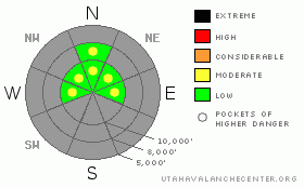
Danger by aspect and elevation on slopes approaching 35° or steeper.
(click HERE for tomorrow's danger rating)
|
Danger Rose Tutorial
|
Today, there are pockets of MODERATE avalanche danger on steep slopes for shallow, hard wind drifts that could crack out beneath the weight of a person. These drifts, or slabs, will be found on both mid and upper elevation shady slopes with snow cover. Terrain not affected by the wind has a LOW danger.
|
|
|
CURRENT CONDITIONS |

|
A week of sun and high pressure once again melted the southeast through westerly facing slopes back down to dirt, leaving the limited options for turning and riding unchanged - upper elevation(above about 9,500’), northwest through easterly facing slopes. Unfortunately, most snow surfaces are very wind damaged; sporting a variety of breakable crusts, and rock evasion skills are still prized due to the very shallow snowpack.
For the past 20 hours, mid and upper elevation winds have been from the southeast to southwest, averaging 20 mph, with gusts in the 40’s. Speeds across many of the exposed ridge crests averaged 35 mph, with gusts to 80 mph. With the cold front already past, wind speeds are decreasing, and temperatures are falling, currently in the upper teens to low 30’s.
|
|
|
RECENT ACTIVITY |

|
Yesterday’s winds created shallow, hard wind slabs, 2 to 6 inches thick, that cracked easily, failing on the weak near surface facets. The largest triggered wind slab was 50' across, but very short running.
|
|
|
THREAT #1 |

|
| WHERE |
PROBABILITY |
SIZE |
TREND |

|
|
|
|
| |
|
|
Over the next
24 hours.
|
|
|
The shallow, hard wind drifts, or slabs, are today’s main avalanche concern. Wind slabs could be a bit thicker and more widespread today after a night of continued wind. They are sitting on sugary small grained faceted snow, and crack out easily under the weight of a person. In most places, they are shallow and break into such small pieces, that they are not a concern. But in a few spots on steep slopes, they could be thick and wide enough to knock you off your feet or take you for a short ride. And even a short ride down slope could have serious consequences due to the high probability of hitting a rock.
Looking toward the future, the multiple weak faceted layers in the snow pack have little prospect of strengthening, and I am anticipating an avalanche cycle once we get a decent storm. So, as you’re wandering around in the backcountry, make a note of the snowpack condition for the future.
|
|
|
MOUNTAIN WEATHER |

|
The cold front has already slipped into northern Utah, bringing light snow to the Logan and Ogden area mountains. South of I-80, we can only hope for a few snow flurries later this morning, with a trace to 2” possible. Temperatures will continue to fall, into the 20’s at 8,000’ and into the teens at 10,000’. The winds will become more westerly, and decrease into the 10 to 20 mph range. Partly cloudy skies tonight, with light westerly winds, and temperatures in the teens and single digits. The next storm, forecast to arrive late Sunday afternoon, should be a slightly better snow producer, with showers lingering into Monday morning. However, once this small storm moves through, we are stuck once again with high pressure for most of next week. |
|
|
GENERAL ANNOUNCEMENTS |
|
Envision Utah is looking for input on the “Wasatch Canyons Tomorrow” update of the County's 1989 Plan, in partnership with Salt Lake City, the State of Utah and the US Forest Service. There is an online survey “Wasatch Canyons Tomorrow” at http://www.envisionutah.org/index.html .
We will be issuing intermittent morning or afternoon avalanche advisories as conditions change.
Our web site is now formatted for iPhone. You can also download a free iPhone application from Canyon Sports to display the Bottom Line. Search for Utah Avalanche on the Apple's iPhone Apps page or in iTunes.
If you want to get this avalanche advisory e-mailed to you daily click HERE.
For a text only version, the link is on the left side bar, near the top.
UDOT highway avalanche control work info can be found by calling (801) 975-4838. Our statewide toll free line is 1-888-999-4019 (early morning, option 8).
Donate to your favorite non-profit – The Friends of the Utah Avalanche Center. The UAC depends on contributions from users like you to support our work. To find out more about how you can support our efforts to continue providing the avalanche forecasting and education that you expect please visitour Friends page.
We appreciate avalanche and snow observations. If there’s something we should know about give us a call at (801) 524-5304 or 1-800-662-4140, or email us at uac@utahavalanchecenter.org. (Fax 801-524-6301).
The information in this advisory is from the U.S. Forest Service, which is solely responsible for its content. This advisory describes general avalanche conditions and local variations always occur.
|
|
|
This information does not apply to developed ski areas or highways where avalanche control is normally done. This advisory is from the U.S.D.A. Forest Service, which is solely responsible for its content. This advisory describes general avalanche conditions and local variations always occur. |
|
This advisory provided by the USDA Forest Service, in partnership with:
The Friends of the Utah Avalanche Center, Utah Division of State Parks and Recreation, Utah Division of Emergency Management, Salt Lake County, Salt Lake Unified Fire Authority and the friends of the La Sal Avalanche Center. See our Sponsors Page for a complete list. |
