SPECIAL ANNOUNCEMENT |
 |
We will continue to issue intermittent morning or afternoon avalanche advisories as we wait for winter to truly arrive. In the meantime, check out the updates to our web site, including the new avalanche education page, where you can search for classes by date, course type or region. |
|
|
BOTTOM LINE
Danger by aspect and elevation on slopes approaching 35° or steeper.
(click HERE for tomorrow's danger rating)
|
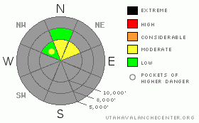
Danger Rose Tutorial
|
Today, Saturday, will be a day of increasing avalanche danger. As the storm’s arrival brings new snow and stronger winds, the avalanche danger will rise to MODERATE on steep, upper elevation northerly and easterly facing slopes with old snow from October on the ground. Sluffs and shallow soft slab avalanches will become easier to trigger as the snow piles up this afternoon, especially in wind drifted areas. |
|
|
CURRENT CONDITIONS |

|
The meager snowpack is only deep enough for turning and riding on upper elevation northerly facing slopes (above about 9,500’ or 10,000’), and you will still find yourself dodging rocks and stumps. Slopes with a bit of an easterly facing component have a slick, supportable crust beneath Thursday’s 4-6” of dust, while more northerly facing slopes have two storms worth of powder above weaker crusts. Winds this morning are still from the southwest, generally averaging less than 15 mph. Temperatures are in the low 20’s to low teens at the 8 to 10,000’ levels. If you’re using the closed or partially closed ski areas to access the higher terrain, be considerate and comply with any signage. |
|
|
RECENT ACTIVITY |

|
Sluffing of the cold, loose snow on the hard crusts was the only avalanche activity reported from Friday. |
|
|
THREAT #1 |

|
| WHERE |
PROBABILITY |
SIZE |
TREND |

|
|
|
|
| |
|
|
Over the next
12 hours.
|
|
|
Field work at the upper elevations yesterday found a classic bed surface with a weak layer, but no slab. Today’s new snow and stronger winds could create that soft slab on some slopes, providing the final ingredient for a slab avalanches.
While there’s lots of the usual early season variability, there seem to be two general snowpack patterns. On slopes with a easterly component that receive some sun over the past few weeks, only Thursday’s fluff is sitting on very hard, slick crusts, and it was easy to get this snow moving in sluffs on steep slopes yesterday. On more northerly facing slopes, there are two storms worth of snow above the crust, with the lower older layer faceted. On these sheltered, due north facing slopes, any sluffs or slides triggered later this afternoon will be just a bit deeper, and perhaps more sensitive due to the layer of facets. We’re not expecting enough weight out of this storm to break into the facets beneath the crusts, but they're worth keeping an eye on. |
|
|
MOUNTAIN WEATHER |

|
A fast moving storm system will bring a quick shot of snow to the northern Utah mountains today, favoring terrain south of I-80. Light snowfall has begun in the mountains, and the heaviest snowfall is expected late morning into early afternoon with and behind the cold front. Storm totals of 6 to 11” are possible at the higher elevations south of I-80, with 4 to 8” expected north of I-80. With the arrival of the front, the current southwesterly winds will shift to the northwest and increase into the 15 to 25 mph range, with gusts in the 30’s. Temperatures will remain in the teens today, dropping into the single digits tonight. High pressure will build back into the area tonight, and remain over northern Utah though the first half of next week. |
|
|
GENERAL ANNOUNCEMENTS |
|
Envision Utah is looking for input on the “Wasatch Canyons Tomorrow” update of the County's 1989 Plan, in partnership with Salt Lake City, the State of Utah and the US Forest Service. There is an online survey “Wasatch Canyons Tomorrow” at http://www.envisionutah.org/index.html .
We will be issuing intermittent morning or afternoon avalanche advisories as conditions change.
Our web site is now formatted for iPhone. You can also download a free iPhone application from Canyon Sports to display the Bottom Line. Search for Utah Avalanche on the Apple's iPhone Apps page or in iTunes.
If you want to get this avalanche advisory e-mailed to you daily click HERE.
For a text only version, the link is on the left side bar, near the top.
UDOT highway avalanche control work info can be found by calling (801) 975-4838. Our statewide toll free line is 1-888-999-4019 (early morning, option 8).
Donate to your favorite non-profit – The Friends of the Utah Avalanche Center. The UAC depends on contributions from users like you to support our work. To find out more about how you can support our efforts to continue providing the avalanche forecasting and education that you expect please visitour Friends page.
We appreciate avalanche and snow observations. If there’s something we should know about give us a call at (801) 524-5304 or 1-800-662-4140, or email us at uac@utahavalanchecenter.org. (Fax 801-524-6301).
The information in this advisory is from the U.S. Forest Service, which is solely responsible for its content. This advisory describes general avalanche conditions and local variations always occur. |
|
|
This information does not apply to developed ski areas or highways where avalanche control is normally done. This advisory is from the U.S.D.A. Forest Service, which is solely responsible for its content. This advisory describes general avalanche conditions and local variations always occur. |
|
This advisory provided by the USDA Forest Service, in partnership with:
The Friends of the Utah Avalanche Center, Utah Division of State Parks and Recreation, Utah Division of Emergency Management, Salt Lake County, Salt Lake Unified Fire Authority and the friends of the La Sal Avalanche Center. See our Sponsors Page for a complete list. |
