SPECIAL ANNOUNCEMENT |
 |
The Friends of the Utah Avalanche Center's first annual Snow Kills Benefit Concert tonight at Liquid Joe's is bound to be an epic party on a Friday night. Music by Melodicious, Sober Down, Funk and Gonzo, and the farewell concert for Herban Empire. In between sets we have a pile of merchandise that we are just dying to give away. Our sponsors include Skullcandy, The Canyons Ski Resort, Alta Ski Resort, Monster Energy Drinks, Surface Board Shop, The One Love Club, Powderwhore Films and Diva's Coffee Shop. We will be partying all night. Don't miss this one. Satisfaction Guaranteed. Liquid Joe's is on 3300 South and 1249 East. More info at http://www.facebook.com/event.php?eid=193144086013 |
|
|
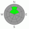
BOTTOM LINE
Danger by aspect and elevation on slopes approaching 35° or steeper.
(click HERE for tomorrow's danger rating)
|
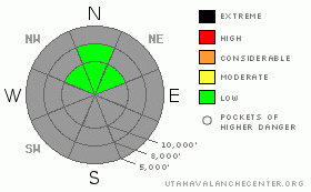
Danger Rose Tutorial
|
The main danger today is hitting hidden rocks beneath 4 inches of new snow. Presently, there is a LOW danger of human triggered avalanches but the danger will rise on Saturday.
On Saturday and Saturday night, we are expecting 4-7 inches of additional snow. The winds are forecasted to kick up a little as the cold front passes Saturday afternoon, which will likely be enough to create localized areas of wind slabs on steep slopes where you can trigger some of the first avalanches of the season. Be sure to jump on test slopes and test the snow carefully as you travel. |
|
|
CURRENT CONDITIONS |

|
Last night the snow fairy made a rare visit and dusted the higher elevations with 4 inches of the good stuff, which was a nice gesture, but not nearly enough. Only four measly inches in a bony fall like this is more of a cruel joke because it just covers up the rocks that lurk like shark's teeth just beneath the surface. But the good news is that we have perhaps 7 more inches on the way on Saturday and the later part of next week looks quite promising.
The only places with enough snow for anything resembling winter recreation exists on northwest, north and northeast facing slopes above about 9,500'.
Temperatures have cooled down into the mid teens and winds are light out of the south. |
|
|
RECENT ACTIVITY |

|
There was no reported avalanche activity from this light dusting of snow. |
|
|
THREAT #1 |

|
| WHERE |
PROBABILITY |
SIZE |
TREND |
|
|
|
|
| |
|
|
Over the next
24 hours.
|
|
|
The new snow wasn't enough to change the avalanche conditions very much. The pre-existing snow is a smorgasbord of old wind and sun crusts with occasional patches of thin, faceted snow. I think the new snow will bond fairly well to the old snow with the exception of sick crusts on the very steep slopes.
Mostly, we are just waiting for more snow and I'm betting that we will see some of our first, significant avalanche activity on Saturday when enough new, and windblown, snow has overloaded last night's snow. You will find these pockets where you could trigger an avalanche mostly on steep slopes with recent wind drifts. You should, as always, carefully check to see how well the new snow is bonding to the underlying snow by digging down quickly with your hand and pulling on small blocks that you cut out with your mittens. |
|
|
MOUNTAIN WEATHER |

|
Saturday we have round 2 impacting Utah with a cold, fast-moving storm expected most of Saturday and cold front passage Saturday afternoon. It appears like it will give us an additional 5-8 inches of snow, and as usual this time of year, I hope I have under forecast. Snow should die down to showers on Saturday night and linger with some light snow showers on Sunday.
Ridge top temperatures will be mighty chilly--down around the mid teens on Saturday and in the lower teens on Saturday night.
The extended forecast calls for warming up through the first part of the week and the chance for a more significant series of storms starting on about Thursday. |
|
|
This information does not apply to developed ski areas or highways where avalanche control is normally done. This advisory is from the U.S.D.A. Forest Service, which is solely responsible for its content. This advisory describes general avalanche conditions and local variations always occur. |
|
This advisory provided by the USDA Forest Service, in partnership with:
The Friends of the Utah Avalanche Center, Utah Division of State Parks and Recreation, Utah Division of Emergency Management, Salt Lake County, Salt Lake Unified Fire Authority and the friends of the La Sal Avalanche Center. See our Sponsors Page for a complete list. |
