SPECIAL ANNOUNCEMENT |
 |
The Friends of the Utah Avalanche Center's first annual Snow Kills Benefit Concert is bound to be an epic party on a Friday night. Music by Melodicious, Sober Down, Funk and Gonzo, and the farewell concert for Herban Empire. In between sets we have a pile of merchandise that we are just dying to give away. Our sponsors include Skullcandy, The Canyons Ski Resort, Alta Ski Resort, Monster Energy Drinks, Surface Board Shop, The One Love Club, Powderwhore Films and Diva's Coffee Shop. We will be partying all night. Don't miss this one. Satisfaction Guaranteed. More info at http://www.facebook.com/event.php?eid=193144086013 |
|
|
BOTTOM LINE
Danger by aspect and elevation on slopes approaching 35° or steeper.
(click HERE for tomorrow's danger rating)
|
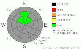
Danger Rose Tutorial
|
The weakening snowpack is increasing the chance for hitting rocks and stumps in the few places at the higher elevations where there in enough snow for turning and riding. The upcoming storm could increase the avalanche danger on slopes with old snow due to poor bonding to the old, slick snow surfaces. We’ll be doing more frequent updates at the weather turns more wintery.
|
|
|
CURRENT CONDITIONS |

|
We are still waiting for that definitive series of storms to usher in the “official” start to the winter of 2009-2010. In the mean time, you can catch a few turns in isolated areas on upper elevation, shady slopes with smooth ground surface beneath. However, they may not be that pleasant, as much of the old snow is a mess of supportable and breakable surface crusts, overlying weakening sugar snow.
|
|
|
THREAT #1 |

|
| WHERE |
PROBABILITY |
SIZE |
TREND |

|
|
|
|
| |
|
|
Over the next
48 hours.
|
|
|
Today is a final good day to check out the distribution of the remaining old snow, and even take a few photos of the coverage. The concern for the future is the steep, shady upper elevation slopes where the old October snow has weakened in to sugary snow that’s capped with slick crusts. With a small storm on the way, there’s the potential for poor bonding of the new snow to the old snow surface, which could result in sluffs and possible shallow new snow slabs, especially in wind drifted areas.
Below the crusts, there are sugary facets that could become a potential weak layer in the future. Luckily, many snow covered slopes have numerous anchors sticking out through the old snow, and this will be a problem isolated to a few, smoother, snowier slopes.
|
|
|
MOUNTAIN WEATHER |

|
One last cloudy, mild day ahead of Thursday’s storm, with the southwesterly winds increasing into the 20 to 40 mph range and gusts reaching into the 50’s across the higher terrain. The cold front is forecast to cross northern Utah Thursday morning, but the storm looks to favor the central and southern mountains. For the northern mountains, 6 to 10” of new snow is possible by Friday morning. However, a second, colder storm system Friday night into Saturday could be a better snow producer for the northern mountains.
|
|
|
This information does not apply to developed ski areas or highways where avalanche control is normally done. This advisory is from the U.S.D.A. Forest Service, which is solely responsible for its content. This advisory describes general avalanche conditions and local variations always occur. |
|
This advisory provided by the USDA Forest Service, in partnership with:
The Friends of the Utah Avalanche Center, Utah Division of State Parks and Recreation, Utah Division of Emergency Management, Salt Lake County, Salt Lake Unified Fire Authority and the friends of the La Sal Avalanche Center. See our Sponsors Page for a complete list. |
