BOTTOM LINE
Danger by aspect and elevation on slopes approaching 35° or steeper.
(click HERE for tomorrow's danger rating)
|
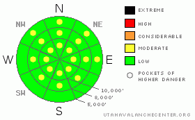
Danger Rose Tutorial
|
Each day, with sun and warming temperatures, the avalanche danger will rise to MODERATE for easily triggered wet loose sluffs on slopes steeper than about 35 degrees. In the steepest terrain, a few predictable, natural sluffs will be possible during the hottest part of the day. Also, there is a localized MODERATE danger of triggering a drift of windblown snow in upper elevation terrain. |
|
|
CURRENT CONDITIONS |

|
It’s a blustery morning, with the southerly winds gusting in the 40s and 50s at the higher elevations. At the mid elevations, speeds are averaging in the 10 to 20 mph range, with gusts to 40. Temperatures warmed overnight into the 30s and 40s, with just a few readings in the 20s remaining as you approach 11,000’. Between the wind and warmth, yesterday’s powder will be a scarce commodity today, but check out the sheltered mid to upper elevation northerly facing slopes for the last remains. Elsewhere, the snow should be headed toward some sort of corn cycle, with the recent snow temporarily covering up the red dust layer. |
|
|
RECENT ACTIVITY |

|
Observations from the past few days have been of a few shallow new snow soft slabs, especially in wind drifted areas, and with yesterday’s heating, a round of wet loose sluffs on the east through south through west facing slopes and at the lower elevations. Again, these wet sluffs were within the new snow only, running on the old crusts. |
|
|
THREAT #1 |

|
| WHERE |
PROBABILITY |
SIZE |
TREND |

|
|
|
|
| |
|
|
Over the next
24 hours.
|
|
|
Winds at the higher elevations were drifting dry snow yesterday, evidenced by the plumes that could be seen even from the valley. Today, there will be localized areas in upper elevation terrain where sensitive drifts could be triggered, especially along the ridgelines and on the slopes facing the north ½ of the compass. Cracking in the surface snow will be a clue that you’re in a wind drifted area. |
|
|
THREAT #2 |

|
| WHERE |
PROBABILITY |
SIZE |
TREND |

|
|
|
|
| |
|
|
Over the next
12 hours.
|
|
|
It will continue to be possible to easily trigger wet loose sluffs with heating today. While the sluffs are shallow, they will be running on the old hard icy crust, and could knock you off balance or take you for a ride. Avoid terrain where you could be pushed into trees, off a cliff, taken for a long ride or shoved into a terrain trap and buried, such as in a gully or creek bed. |
|
|
MOUNTAIN WEATHER |

|
A series of weak weather disturbances will brush northern Utah through Thursday, with a chance for occasional light snowfall. Today, increasing clouds, with a slight chance for isolated snow showers this afternoon and tonight, especially north of I-80. The southwesterly winds will be strongest this afternoon, with 20 to 30 mph averages and gusts in the 40’s in mid elevation terrain. Along the highest ridges, gusts will be in the 60’s. Temperatures will warm into the mid 30’s at 10,000’ and the low 50’s at 8,000’. Wednesday and Thursday will bring partly cloudy skies with slightly cooler temperatures. There’s a better chance for snow this weekend, with a moist Pacific storm system forecast to affect northern Utah. Be sure to monitor the National Weather Service web site to follow the storm’s progress (use the links on our Weather page). |
|
|
GENERAL ANNOUNCEMENTS |
|
We will be issuing intermittent avalanche advisories until around the end of April.
Our web site is now formatted for iPhone. You can also download a free iPhone application from Canyon Sports to display the Bottom Line. Search for Utah Avalanche on the Apple's iPhone Apps page or in iTunes.
If you want to get this avalanche advisory e-mailed to you daily click HERE.
For a text only version, the link is on the left side bar, near the top.
UDOT highway avalanche control work info can be found by calling (801) 975-4838. Our statewide toll free line is 1-888-999-4019 (early morning, option 8).
Donate to your favorite non-profit – The Friends of the Utah Avalanche Center. The UAC depends on contributions from users like you to support our work. To find out more about how you can support our efforts to continue providing the avalanche forecasting and education that you expect please visitour Friends page.
We appreciate any and all late season avalanche and snow observations, so keep them coming! Leave us a message at (801) 524-5304 or 1-800-662-4140, or email us at uac@utahavalanchecenter.org. (Fax 801-524-6301).
The information in this advisory is from the U.S. Forest Service, which is solely responsible for its content. This advisory describes general avalanche conditions and local variations always occur. |
|
|
This information does not apply to developed ski areas or highways where avalanche control is normally done. This advisory is from the U.S.D.A. Forest Service, which is solely responsible for its content. This advisory describes general avalanche conditions and local variations always occur. |
|
This advisory provided by the USDA Forest Service, in partnership with:
The Friends of the Utah Avalanche Center, Utah Division of State Parks and Recreation, Utah Division of Emergency Management, Salt Lake County, Salt Lake Unified Fire Authority and the friends of the La Sal Avalanche Center. See our Sponsors Page for a complete list. |
