Salt Lake Avalanche Advisory

Forecaster: Drew Hardesty

SPECIAL ANNOUNCEMENT

We will be issuing intermittent avalanche advisories for the rest of the season.


BOTTOM LINE

Danger by aspect and elevation on slopes approaching 35° or steeper.
(click HERE for tomorrow's danger rating)


Danger Rose Tutorial

The danger of wet sluffs and slabs will rise to CONSIDERABLE on all steep sun exposed terrain. Like most thing in life, timing is everything. Be off of and out from underneath steep sunny aspects with extensive solar radiation. Continue with safe travel protocol. A rogue wind slab just off the ridgelines should be considered in high, steep old windloaded terrain.


CURRENT CONDITIONS

Storm totals since Tuesday are over 3 feet of dense snow in the upper elevations of the Cottonwood Canyons and Park City with 3-4 inches of water weight. The storm was quite warm, so new snow amounts were very elevation dependent. With the Low drawing to the east, building high pressure, clearing skies and a dramatic warm up by mid-week will take center stage.


RECENT ACTIVITY

With some clearing, wet sluff-inititated slab-pockets released in some mid-track terrain on southerly facing aspects by Friday afternoon. Other explosive work at the ski areas continued to yield 1-2' deep slabs from the mid-week deluge.


THREAT #1

WHERE PROBABILITY SIZE TREND
      Over the next 8 hours.

Despite the slow warm-up, the first day of clear skies should continue to be productive for the wet activity. Suspect layering includes potential intrastorm weaknesses such as graupel, lighter density snow and snirt layers.


MOUNTAIN WEATHER

Temps will rise to the upper 30's and we should have partly-becoming-sunny skies on Saturday. Winds should be light to moderate from the north to northwest.


GENERAL ANNOUNCEMENTS

We will be issuing intermittent avalanche advisories for the rest of the season. We will likely issue advisories each afternoon this week through the storm cycle, and then go back to more intermittent advisories as the avalanche conditions stabilize.

Our web site is now formatted for iPhone. You can also download a free iPhone application from Canyon Sports to display the Bottom Line. Search for Utah Avalanche on the Apple's iPhone Apps page or in iTunes.

If you want to get this avalanche advisory e-mailed to you daily click HERE.

For a text only version, the link is on the left side bar, near the top.

UDOT highway avalanche control work info can be found by calling (801) 975-4838. Our statewide toll free line is 1-888-999-4019 (early morning, option 8).

Donate to your favorite non-profit – The Friends of the Utah Avalanche Center. The UAC depends on contributions from users like you to support our work. To find out more about how you can support our efforts to continue providing the avalanche forecasting and education that you expect please visitour Friends page.

We appreciate any and all late season avalanche and snow observations, so keep them coming!! Please leave us a message at (801) 524-5304 or 1-800-662-4140, or email us at uac@utahavalanchecenter.org. (Fax 801-524-6301).

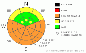
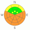
The information in this advisory is from the U.S. Forest Service, which is solely responsible for its content. This advisory describes general avalanche conditions and local variations always occur.

I will update this advisory on Friday afternoon.


This information does not apply to developed ski areas or highways where avalanche control is normally done.  This advisory is from the U.S.D.A. Forest Service, which is solely responsible for its content. This advisory describes general avalanche conditions and local variations always occur.


This advisory provided by the USDA Forest Service, in partnership with:

The Friends of the Utah Avalanche Center, Utah Division of State Parks and Recreation, Utah Division of Emergency Management, Salt Lake County, Salt Lake Unified Fire Authority and the friends of the La Sal Avalanche Center. See our Sponsors Page for a complete list.