SPECIAL ANNOUNCEMENT |
 |
We will be issuing intermittent avalanche advisories for the rest of the season as conditions change. This advisory is for Monday, April 6 and Tuesday, April 7th. The next update will be Wednesday, April87th unless conditions change. |
|
|
BOTTOM LINE
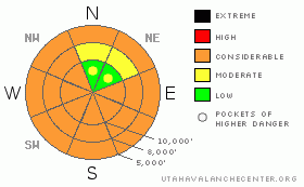
Danger by aspect and elevation on slopes approaching 35° or steeper.
(click HERE for tomorrow's danger rating)
|

Danger Rose Tutorial
|
For Monday and Tuesday, April 6 - 7: The avalanche danger will be LOW early each morning, but rapidly rise to CONSIDERABLE for wet avalanches each day with sun and heating. Wet sluffs will easily be triggered by people on steep slopes, and a natural avalanche cycle will be possible each day. So get off of and out from under steep sunny slopes once the day heats up. There are also pockets of MODERATE danger on mid and upper elevation slopes with cold, dry snow, where sluffs, isolated old shallow wind drifts and huge cornices can be triggered. |
|
|
CURRENT CONDITIONS |

|
Under Monday morning’s clear skies, temperatures are 5 to 10 degrees warmer than Sunday morning at the 10 and 11,000’ levels. They are currently in the 15 to 25 degree range, and the winds are very light and variable, averaging less than 10 mph at all elevations. For a great way to quickly check temperature trends graphically each morning, click here. Sunday’s strong blast of sun and spring temperatures heated the snow on every aspect and elevation except northerly facing slopes above about 9,000’. So while most slopes will be crusted early each morning, the snow will rapidly warm to the consistency of damp mashed potatoes. A thin wedge of dense powder remains on the highest, most northerly facing slopes. |
|
|
RECENT ACTIVITY |

|
Yesterday’s big excitement was a wild ride on a cornice that broke beneath a skier booting up the Millicent ridge line. Check here for full details. In addition, there were parades of roller balls, wet loose sluffs and small damp slabs, running both with human triggers and spontaneously, on most aspects and elevations. |
|
|
THREAT #1 |

|
| WHERE |
PROBABILITY |
SIZE |
TREND |

|
|
|
|
| |
|
|
Over the next
10 hours.
|
|
|
Sun and heat…it’s a simple story for the next two days. Each day, as the snow heats up it will become easy to triggered wet slides, from minor sluffs to long running slides entraining snow as they move down slope and resulting in large debris piles. There is also a possibility of a noteworthy natural avalanche cycle each day. On Tuesday, periods of high thin clouds may increase the heating on northerly facing slopes, with mid to upper elevation shady slopes becoming sensitive.
So spring conditions, mean spring travel habits. Start your day early, and finish early – before noon is quite reasonable. Anticipate the baking heat and plan your backcountry tours with safe exits in mind so you stay off steep slopes once they heat up, avoid avalanche path runouts, and evade terrain traps such as gullies and creek beds where even a small sluff can pile up deeply. |
|
|
THREAT #2 |

|
| WHERE |
PROBABILITY |
SIZE |
TREND |

|
|
|
|
| |
|
|
Over the next
24 hours.
|
|
|
On upper elevation slopes and ridgelines with cool, dry snow, there could be a few lingering instabilities where old wind drifts could crack out. Give cornices a wide berth – they are huge and becoming very sensitive with heating. They will break off much further back than expected, and can even drop off spontaneously, possibly triggering a slide on the slope below. |
|
|
MOUNTAIN WEATHER |

|
Two more scorching days are on tap for the mountains of northern Utah. Monday’s high temperatures will be in the low 30s at 10,000’ and mid 40s at 8,000’. Tuesday will be even hotter, reaching the mid 30s at 10,000’ and near 50 at 8,000’. Monday, skies will be clear and the winds will remain less than 10 mph. Tuesday, a few high thin clouds will break the monotony, and winds will shift to the southwest, and increase into the 10 to 20 mph range, with gusts to 40 along the higher ridgelines. Relief from the heat wave will come in the form of a weak storm on Wednesday, which will bring snow to the higher elevations, with a rain/snow line around 7,000’. Additional snow and rain are possible over the weekend. |
|
|
GENERAL ANNOUNCEMENTS |
Wasatch Powderbird Guides flew in American Fork on Sunday, and plan to be in Cascade on Monday. Check their operations planning page is here.
Our web site is now formatted for iPhone. You can also download a free iPhone application from Canyon Sports to display the Bottom Line. Search for Utah Avalanche on the Apple's iPhone Apps page or in iTunes.
Beacon training parks are up and running! There is one at Snowbasin, one on the Park City side at the top of Canyon’s gondola toward the Tombstone lift, one in Little Cottonwood near the Snowbird parking structure on the bypass road, and in Big Cottonwood a training park is at the west end of Solitude's lower parking lot.
If you want to get this avalanche advisory e-mailed to you daily click HERE.
For a text only version, the link is on the left side bar, near the top.
UDOT highway avalanche control work info can be found by calling (801) 975-4838. Our statewide toll free line is 1-888-999-4019 (early morning, option 8).
Donate to your favorite non-profit – The Friends of the Utah Avalanche Center. The UAC depends on contributions from users like you to support our work. To find out more about how you can support our efforts to continue providing the avalanche forecasting and education that you expect please visitour Friends page.
Your snow and avalanche observations can save someone’s life. Please let us know what you're seeing by leaving a message at (801) 524-5304 or 1-800-662-4140, or email us at uac@utahavalanchecenter.org. (Fax 801-524-6301).
The information in this advisory is from the U.S. Forest Service, which is solely responsible for its content. This advisory describes general avalanche conditions and local variations always occur.
Brett Kobernik will update this advisory on Wednesday, April 8th. |
|
|
This information does not apply to developed ski areas or highways where avalanche control is normally done. This advisory is from the U.S.D.A. Forest Service, which is solely responsible for its content. This advisory describes general avalanche conditions and local variations always occur. |
|
This advisory provided by the USDA Forest Service, in partnership with:
The Friends of the Utah Avalanche Center, Utah Division of State Parks and Recreation, Utah Division of Emergency Management, Salt Lake County, Salt Lake Unified Fire Authority and the friends of the La Sal Avalanche Center. See our Sponsors Page for a complete list. |

