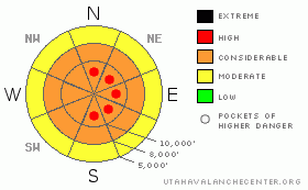
BOTTOM LINE
Danger by aspect and elevation on slopes approaching 35° or steeper.
(click HERE for tomorrow's danger rating)
|
Danger Rose Tutorial
|
The avalanche danger is CONSIDERABLE in the upper elevation, wind affected terrain and terrain that received more than about 18” on new snow. There are pockets of HIGH danger in upper elevations of Little Cottonwood and mid Big Cottonwood, which have received the most snow and have the strongest winds. Use careful route finding, good travel habits and conservative decision making. Out of the wind affected terrain, and in areas that received less than about a foot of new snow, the avalanche danger is MODERATE, with human triggered soft slabs and sluffs possible on steep slopes. Evaluate the snow and terrain carefully and use good travel habits. Be alert for any changes such as an increase in snowfall rates or wind or direct sun where you are today, which could rapidly increase the danger.
|
|
|
CURRENT CONDITIONS |

|
The overnight portion of the storm turned out to be the winner, and 24 hour storm totals are now in the 20 to 28” range in upper Little Cottonwood and mid Big Cottonwood, with 8 to 14” in upper Big Cottonwood, on the Park City side and in the Ogden area mountains, and 6 to 10” in the Provo area mountains. It’s classic Utah powder, with densities less than 8%. Temperatures have plunged into the single digits and low teens. After almost 24 hours of nuking southwesterly to northwesterly winds, speeds finally started to drop off a few hours ago at the mid and lower elevations. The northwesterly winds are currently in the 10 to 15 mph range, gusting into the 30s. Unfortunately, the highest terrain still has averages of 35 to 45 mph, with gusts in the 60’s.
|
|
|
RECENT ACTIVITY |

|
Avalanche activity on Sunday was limited to a few observations of naturally occurring sluffs and shallow soft slabs, some triggered by sensitive cornices dropping off. There were no backcountry observations from the windiest higher elevation terrain.
|
|
|
THREAT #1 |

|
| WHERE |
PROBABILITY |
SIZE |
TREND |
|
|
|
|
| |
|
|
Over the next
24 hours.
|
|
|
The strong, southwest to northwesterly winds for the past 24 hours have drifted snow on a wide variety of aspects and elevations. While the most widespread drifting will be on slopes facing north through southeast, drifts will be cross loaded on to other aspects and elevations. Be alert for drifting well off ridgelines, around terrain features such as gully walls, breakovers and sub ridges. Some of yesterday’s harder drifts will be hidden beneath the most recent snow. Both these soft and hard wind drifts will be sensitive, especially this morning, and crack out under the weight of a person.
|
|
|
THREAT #2 |

|
| WHERE |
PROBABILITY |
SIZE |
TREND |
|
|
|
|
| |
|
|
Over the next
24 hours.
|
|
|
With one to two feet of new snow, approach any steep slope with caution, and expect to be able to trigger new snow soft slabs and sluffs on steep slopes, especially if you’re in an area with a foot or more of new snow. Anytime precipitation rates or winds increase where you are, the avalanche danger will increase, too. So use all your tricks to evaluate the new snow stability - jump on test slopes and use quick hand pits to check for weaknesses within the new snow. Start your day on lower angle slopes and out of wind effected terrain, and use careful cornice kicks and slope cuts.
While most avalanche activity should be within the new snow, there may be a few isolated places where it is possible to break into a deeper layer, with a small area of faceted snow, a thin melt freeze crust or a pool of graupel as the guilty weak layer. Any collapsing or whumphing sounds should be taken seriously, as indications of one of these weak layers, possibly most widespread in the Ogden area mountains.
|
|
|
MOUNTAIN WEATHER |

|
An unstable flow behind the exiting storm will keep snow going through mid morning, with an additional 2 to 7 inches of snow possible in areas favored by northwest flow. Hopefully, the worst of the northwesterly winds are over, and most stations should remain in the 10 to 20 mph range with gusts in the 30’s. However, average speeds across the highest, most exposed terrain could continue to be in the 35 to 50 mph through early afternoon. Temperatures will remain in the single digits at 10,000’ today. There will be a break in the action tonight, before the winds shift back to the southwest and increase tomorrow ahead of the next storm starting Tuesday night through Wednesday. Another foot of snow, accompanied with strong northwesterly winds.
|
|
|
GENERAL ANNOUNCEMENTS |
|
Wasatch Powderbird Guides didn’t get out on Sunday and won’t be out today. Check their operations planning page is here.
Our web site is now formatted for iPhone. You can also download a free iPhone application from Canyon Sports to display the Bottom Line. Search for Utah Avalanche on the Apple's iPhone Apps page or in iTunes.
Beacon training parks are up and running! There is one at Snowbasin, one on the Park City side at the top of Canyon’s gondola toward the Tombstone lift, one in Little Cottonwood near the Snowbird parking structure on the bypass road, and in Big Cottonwood a training park is at the west end of Solitude's lower parking lot.
If you want to get this avalanche advisory e-mailed to you daily click HERE.
For a text only version, the link is on the left side bar, near the top.
UDOT highway avalanche control work info can be found by calling (801) 975-4838. Our statewide toll free line is 1-888-999-4019 (early morning, option 8).
Donate to your favorite non-profit – The Friends of the Utah Avalanche Center. The UAC depends on contributions from users like you to support our work. To find out more about how you can support our efforts to continue providing the avalanche forecasting and education that you expect please visitour Friends page.
Your snow and avalanche observations can save someone’s life. Please let us know what you're seeing by leaving a message at (801) 524-5304 or 1-800-662-4140, or email us at uac@utahavalanchecenter.org. (Fax 801-524-6301).
The information in this advisory is from the U.S. Forest Service, which is solely responsible for its content. This advisory describes general avalanche conditions and local variations always occur.
Drew Hardesty will update this advisory by 7:30 tomorrow morning.
|
|
|
This information does not apply to developed ski areas or highways where avalanche control is normally done. This advisory is from the U.S.D.A. Forest Service, which is solely responsible for its content. This advisory describes general avalanche conditions and local variations always occur. |
|
This advisory provided by the USDA Forest Service, in partnership with:
The Friends of the Utah Avalanche Center, Utah Division of State Parks and Recreation, Utah Division of Emergency Management, Salt Lake County, Salt Lake Unified Fire Authority and the friends of the La Sal Avalanche Center. See our Sponsors Page for a complete list. |
