SPECIAL ANNOUNCEMENT |
 |
I will give a free avalanche awareness talk on Tuesday night at 7:00 pm at the JCC, just north of the University of Utah Hospital. Check our home page for details. |
|
|
BOTTOM LINE
Danger by aspect and elevation on slopes approaching 35° or steeper.
(click HERE for tomorrow's danger rating)
|
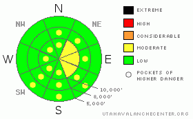
Danger Rose Tutorial
|
The avalanche danger is mostly LOW with pockets of MODERATE danger for fresh, shallow, wind slabs in steep, wind exposed terrain. As always, avoid steep slopes with fresh wind drifts. If the sun comes out, there may also be a MODERATEdanger of shallow, damp sluffs on steep sun exposed slopes. |
|
|
CURRENT CONDITIONS |

|
A heartbreaker of a cold front came through last night dropping a measly 2 inches in the Cottonwood Canyons and 5 inches in the Ogden and Logan area mountains. The Salt Lake area mountains will make a valiant attempt to catch up in the next couple hours, but the storm is rapidly dying. The hot tip for the day is to head to the northerly parts of the state where they have been getting a few inches of snow the past couple days in addition to this latest snow. South of I-80, you should hope for the best but prepare for the worst. With the cold temperatures, the pre-existing, wet snow at lower elevations will resemble concrete traffic barriers with just enough of a dusting on top to make them hard to see. Yesterday, I found the pre-existing dry snow to be crusted and tracked-up and in bad need of some freshies. It’s feeling pretty lonely in my cubicle this morning here at the National Weather Service. The only backcountry observation I got from yesterday was a UDOT forecaster who was paid to be out there and he didn’t seem too excited. Temperatures have plummeted to 5 degrees on the highest peaks and 10 degrees on most ridges. Winds blew overnight 20, gusting to 35 from the west and 30, gusting to 50 at 11,000’. Winds have dropped significantly to 10 mph gusting to 15 from the northwest. |
|
|
RECENT ACTIVITY |

|
There was no new avalanche activity reported from the backcountry yesterday. |
|
|
THREAT #1 |

|
| WHERE |
PROBABILITY |
SIZE |
TREND |

|
|
|
|
| |
|
|
Over the next
24 hours.
|
|
|
With the wet, pre-existing snow frozen solid and the dry, old snow mostly stable, your only avalanche hazard today will be fresh, soft, and mostly shallow, wind slabs. As usual, you should be suspicious of steep slopes with fresh wind deposits, which will look smooth, rounded and chalky. Most of them will be about 6 inches deep, but could be up to a foot on some slopes. |
|
|
THREAT #2 |

|
| WHERE |
PROBABILITY |
SIZE |
TREND |

|
|
|
|
| |
|
|
Over the next
8 hours.
|
|
|
If the sun comes out this afternoon, we may see some shallow, damp sluffs on steep, sun exposed slopes. I suspect it will be cold and windy enough to keep this to a minimum, but you should watch for them. |
|
|
MOUNTAIN WEATHER |

|
The snow has ended north of I-80 and light snow showers should continue south of I-80 this morning and call it quits by mid morning. Temperatures will remain quite cold today with ridge top temperatures clawing their way up to mid to lower teens with a 10 mph wind from the northwest. Clouds should slowly clear out by mid day. Overnight, temperatures will remain very chilly, around 8 degrees on the ridge tops. You should enjoy what little powder we have because ridge top temperatures will pop right back up to freezing for the weekend.
The extended forecast calls for continuing clear, warm weather with a stronger storm for Thursday. |
|
|
GENERAL ANNOUNCEMENTS |
Our web page is now mobile-friendly for users of iPhone and iPod Touch.
Wasatch Powderbird Guides operations planning page is here.
Beacon training parks are up and running! There is one at Snowbasin, one on the Park City side at the top of Canyon’s gondola toward the Tombstone lift, one in Little Cottonwood near the Snowbird parking structure on the bypass road, and in Big Cottonwood a training park is at the west end of Solitude's lower parking lot.
If you want to get this avalanche advisory e-mailed to you daily click HERE.
For a text only version, the link is on the left side bar, near the top.
UDOT highway avalanche control work info can be found by calling (801) 975-4838. Our statewide toll free line is 1-888-999-4019 (early morning, option 8).
The UAC depends on contributions from users like you to support our work. To find out more about how you can support our efforts to continue providing the avalanche forecasting and education that you expect please visitour Friends page.
Your snow and avalanche observations can save someone’s life. Please let us know what you're seeing by leaving a message at (801) 524-5304 or 1-800-662-4140, or email us at uac@utahavalanchecenter.org. (Fax 801-524-6301).
The information in this advisory is from the U.S. Forest Service, which is solely responsible for its content. This advisory describes general avalanche conditions and local variations always occur.
Evelyn Lees will update this advisory by 7:30 tomorrow morning. |
|
|
This information does not apply to developed ski areas or highways where avalanche control is normally done. This advisory is from the U.S.D.A. Forest Service, which is solely responsible for its content. This advisory describes general avalanche conditions and local variations always occur. |
|
This advisory provided by the USDA Forest Service, in partnership with:
The Friends of the Utah Avalanche Center, Utah Division of State Parks and Recreation, Utah Division of Emergency Management, Salt Lake County, Salt Lake Unified Fire Authority and the friends of the La Sal Avalanche Center. See our Sponsors Page for a complete list. |
