BOTTOM LINE
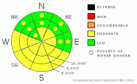
Danger by aspect and elevation on slopes approaching 35° or steeper.
(click HERE for tomorrow's danger rating)
|
Danger Rose Tutorial
|
On slopes steeper than about 35 degrees, the avalanche danger is MODERATE, with sluffs, large cornices and any old or new wind drifts the main concerns. On and below steep sunny slopes, the avalanche danger will increase to MODERATEwith daytime heating and direct sun, and could rise to CONSIDERABLE, with long running damp sluffs creating significant debris piles, especially in gullies or below steep road banks. Low elevation slopes of all aspects could also heat up, with large damp sluffs possible, especially in the Ogden area mountains. On shady, wind sheltered slopes less steep than about 35 degrees, the avalanche danger is generally LOW. |
|
|
CURRENT CONDITIONS |

|
Under partly cloudy skies, instability showers yesterday and overnight added one to 6 inches of fluff to the tremendous Tuesday storm totals (of close to 3 feet in the Ogden area mountains, 2 feet in the Cottonwoods and Provo mountains, and up to a foot and a half on the Park City side). Here is a link to a great NWS product with statewide snow and water equivalents. Temperatures this morning are generally in the teens, with just a few single digit readings at the highest elevations. The westerly winds are averaging 5 to 10 mph, with speeds of 15 mph across a few of the highest peaks. The sun peeked out yesterday, and in some drainages the southeast through westerly facing slopes will have thin crusts this morning. |
|
|
RECENT ACTIVITY |

|
Yesterday, resorts were releasing soft slab avalanches about a foot deep with ski cuts and explosives, especially along the higher ridgelines, and the giant, sensitive cornices released further back than expected in at least once case, sending a driverless VW bus sized block down slope. |
|
|
THREAT #1 |

|
| WHERE |
PROBABILITY |
SIZE |
TREND |

|
|
|
|
| |
|
|
Over the next
12 hours.
|
|
|
New snow instabilities settle out remarkably fast this time of year, leaving those who travel on steep slopes with all the usual cautions. Sluffs may be large enough to catch and carry a person, avoid any old wind drifts and new wind drifts that may be created by this afternoon’s gusty winds, and stay well back from the enormous cornices decorating the ridgelines. Travel defensively, using a rope to saw the huge cornices, slope cuts where appropriate, have only one person on a steep slope at a time, and have an escape plan if you drop a steep line. With a mid-winter pack, there are always a few isolated places where a larger or deeper slide could be triggered – the shady mid and low elevations have a few pockets of surface hoar and facets buried beneath two storms worth of snow that could still be sensitive. One of these deeper slab avalanches would most likely be triggered in a steep gully or on a shady, sheltered northerly facing slope. These faceted weak layers are most widespread in the Ogden area mountains, and could result in a larger slide breaking out above you or from a distance. |
|
|
THREAT #2 |

|
| WHERE |
PROBABILITY |
SIZE |
TREND |

|
|
|
|
| |
|
|
Over the next
10 hours.
|
|
|
Direct sun and warmer temperatures have the potential to create significant wet snow avalanche activity later today. Steep sunny slopes can rapidly heat up, and wet loose sluffs pack a punch, easily catching and carrying a person. Debris piles can be large in continuous steep terrain (widespread in the Provo area mountains and the south facing slopes above Little Cottonwood Canyon road) or in terrain traps such as gullies. Continually monitor the heating of the snow surface - watch for roller balls, damp or sticky snow, or a slabbier feel to the snow surface. Stay off of and out from under steep, sun heated slopes. The northerly facing, low elevation slopes will also heat up and sluff, especially in the Ogden area mountains that received huge amounts of low elevation snow. |
|
|
MOUNTAIN WEATHER |

|
As high pressure builds in, the morning’s partly cloudy skies and isolated snow flurries should rapidly end, with skies becoming mostly sunny. The westerly winds will remain in the 5 to 15 mph range, but gusts will increase into the 30s this afternoon above about 9,500’. Temperatures will warm into the low 30s at 8,000’ and into the 20’s at 10,000’. Slightly warmer and dry conditions will continue through the weekend, followed by a chance for snow on a southwesterly flow starting Sunday night. |
|
|
GENERAL ANNOUNCEMENTS |
Our web page is now mobile-friendly for users of iPhone and iPod Touch.
Wasatch Powderbird Guides did not fly yesterday, and today plan to be in Mineral, Cardiff, Silver, Days and American Fork with home runs through White Pine and Grizzly. Operations planning page is here.
Beacon training parks are up and running! There is one at Snowbasin, one on the Park City side at the top of Canyon’s gondola toward the Tombstone lift, one in Little Cottonwood near the Snowbird parking structure on the bypass road, and in Big Cottonwood a training park is at the west end of Solitude's lower parking lot.
If you want to get this avalanche advisory e-mailed to you daily click HERE.
For a text only version, the link is on the left side bar, near the top.
UDOT highway avalanche control work info can be found by calling (801) 975-4838. Our statewide toll free line is 1-888-999-4019 (early morning, option 8).
The UAC depends on contributions from users like you to support our work. To find out more about how you can support our efforts to continue providing the avalanche forecasting and education that you expect please visitour Friends page.
Your snow and avalanche observations help everyone in the backcountry community. Please let us know what you're seeing by leaving a message at (801) 524-5304 or 1-800-662-4140, or email us at uac@utahavalanchecenter.org. (Fax 801-524-6301).
The information in this advisory is from the U.S. Forest Service, which is solely responsible for its content. This advisory describes general avalanche conditions and local variations always occur.
Bruce Tremper will update this advisory by 7:30 tomorrow morning. |
|
|
This information does not apply to developed ski areas or highways where avalanche control is normally done. This advisory is from the U.S.D.A. Forest Service, which is solely responsible for its content. This advisory describes general avalanche conditions and local variations always occur. |
|
This advisory provided by the USDA Forest Service, in partnership with:
The Friends of the Utah Avalanche Center, Utah Division of State Parks and Recreation, Utah Division of Emergency Management, Salt Lake County, Salt Lake Unified Fire Authority and the friends of the La Sal Avalanche Center. See our Sponsors Page for a complete list. |
