SPECIAL ANNOUNCEMENT |
 |
Our partners, the Friends of the Utah Avalanche Center, with the Snowbird Renaissance Center, are hosting the annual Utah Backcountry Awareness Benefit Dinner and Silent Auction Friday, February 13th, from 5:30-9:00 pm, at Snowbird. It’s a bit of a splurge, but it’s always a very enjoyable evening. Included is dinner, a silent auction, inspirational speaker Chris Waddell chronicling how he overcame a life-changing college skiing accident to become the most decorated male skier in Paralympics history, plus live entertainment by “Stormy Mountain Boys”. For details and tickets, go to the Snowbird Renaissance Center's web site.
|
|
|
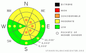
BOTTOM LINE
Danger by aspect and elevation on slopes approaching 35° or steeper.
(click HERE for tomorrow's danger rating)
|
Danger Rose Tutorial
|
We’ll have pockets of CONSIDERABLE with the new windblown snow. They’ll initially be relegated to the upper elevations in terrain with a northerly or easterly component, and I expect them to be quite sensitive. A MODERATE danger exists in the shady mid and low elevations where it’ll be possible to stumble upon areas of preserved, buried weak snow from last week.
Sluff management will be important – look over your shoulder on the way down to not get tangled up in your own loose snow.
|
|
|
CURRENT CONDITIONS |

|
The Central Wasatch squeezed another 3-6” of 4% out of the low level instability yesterday as one observer wrote that “it was really one of those days where you can ski legendary powder in stable conditions.” That about sums it up. Temps are in the low teens and single digits this morning, but the wind is playing the spoiler. Along the Cottonwood ridgeline, they ramped up last night, blowing from the west at 25mph gusting to 35. They’re packing more of a punch in Provo (35 gusting to 45 for the last couple hours) and Ogden mountains (25 gusting to 35mph for the past couple hours). Protected areas at the mid-elevations are nearly calm. A few periods of what Pacific northwesters call “sunbreaks” slightly damaged the snow on localized southerly aspects.
|
|
|
RECENT ACTIVITY |

|
With slightly more gusty winds along the northern crest of the central Wasatch, ski patrol control work triggered numerous soft slabs up to 1-2’ deep. Patrol work at Snowbasin found heightened sensitivity down low on the mountain, with some failure planes on last week’s surface hoar and near surface facets. Ski tourers in the central Wasatch also pulled out a couple pockets running on the feathers. They looked to be about a foot or so deep and, due to the lack of strength of the slab, only 20’ wide or so. These were on steep northerly rollovers at around 7800’ in Mill Creek and Kessler Peak above BCC. Minor, manageable sluffing and shallow soft slabs rounded out the blotter.
|
|
|
THREAT #1 |

|
| WHERE |
PROBABILITY |
SIZE |
TREND |
|
|
|
|
| |
|
|
Over the next
24 hours.
|
|
|
The weather models suggest that the winds will cool it by about mid afternoon, but they’ll provide the first threat for avalanche activity. With so much very low density snow lying around, it won’t take much for them to set up on the lee of ridgelines, sub-ridges, and roll-overs. Test slopes with minor consequences or runouts and move deliberately in exposed terrain from area of safety to area of safety. The drifts may be upwards of 15-24” if the winds persist and may become less manageable. Whumphing and cracking are sure-fire signs of localized instability.
Cornice drops should also be effective, though this technique can be dangerous – ask any old hand about having the cornice break back behind or between their skis.
|
|
|
THREAT #2 |

|
| WHERE |
PROBABILITY |
SIZE |
TREND |
|
|
|
|
| |
|
|
Over the next
24 hours.
|
|
|
The two surface hoar pockets and reports of whumphing/collapsing in Logan, Provo, and Ogden confirm the patchy presence of insulated persistent weak layers in the shady mid and low elevations. Up until now, there hasn’t been much of a load or cohesive slab above.
|
|
|
MOUNTAIN WEATHER |

|
Mostly cloudy to overcast skies with a few flurries today will help preserve the winter landscape. Temps will be in the low teens and the westerly winds are expected to blow 20-25mph from the west. Unsettled weather persists into next week, with one storm after another. Most of the energy will go south of us, but each wave should be enough to keep the powder hounds stoked.
|
|
|
GENERAL ANNOUNCEMENTS |
Wasatch Powderbird Guides did not fly yesterday and most likely won’t fly today due to weather. Operations planning page is here.
Tickets are now available for the annual Backcountry Awareness Dinner on February 13th, with registration through the Snowbird Renaissance Center.
Beacon training parks are up and running! There is one at Snowbasin, one on the Park City side at the top of Canyon’s gondola toward the Tombstone lift, one in Little Cottonwood near the Snowbird parking structure on the bypass road, and in Big Cottonwood a training park is at the west end of Solitude's lower parking lot.
If you want to get this avalanche advisory e-mailed to you daily click HERE.
For a text only version, the link is on the left side bar, near the top.
UDOT highway avalanche control work info can be found by calling (801) 975-4838.
Our statewide toll free line is 1-888-999-4019 (early morning, option 8).
The UAC depends on contributions from users like you to support our work. To find out more about how you can support our efforts to continue providing the avalanche forecasting and education that you expect please visitour Friends page.
Your snow and avalanche observations help everyone in the backcountry community. Please let us know what you're seeing by leaving a message at (801) 524-5304 or 1-800-662-4140, or email us at uac@utahavalanchecenter.org. (Fax 801-524-6301).
Evelyn will update this advisory by 7:30 tomorrow morning.
|
|
|
This information does not apply to developed ski areas or highways where avalanche control is normally done. This advisory is from the U.S.D.A. Forest Service, which is solely responsible for its content. This advisory describes general avalanche conditions and local variations always occur. |
|
This advisory provided by the USDA Forest Service, in partnership with:
The Friends of the Utah Avalanche Center, Utah Division of State Parks and Recreation, Utah Division of Emergency Management, Salt Lake County, Salt Lake Unified Fire Authority and the friends of the La Sal Avalanche Center. See our Sponsors Page for a complete list. |
