SPECIAL ANNOUNCEMENT |
 |
Our partners, the Friends of the Utah Avalanche Center, with the Snowbird Renaissance Center, are hosting the annual Utah Backcountry Awareness Benefit Dinner and Silent Auction Friday, February 13th, from 5:30-9:00 pm, at Snowbird. It’s a bit of a splurge, but it’s always a very enjoyable evening. Included is dinner, a silent auction, inspirational speaker Chris Waddell chronicling how he overcame a life-changing college skiing accident to become the most decorated male skier in Paralympics history, plus live entertainment by “Stormy Mountain Boys”. For details and tickets, go to the Snowbird Renaissance Center's web site.
|
|
|
BOTTOM LINE
Danger by aspect and elevation on slopes approaching 35° or steeper.
(click HERE for tomorrow's danger rating)
|
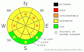
Danger Rose Tutorial
|
The danger is mostly Moderate today with a few pockets of Considerable. The Considerable is purely attributed to the uncertainty of the distribution of last week’s buried weak surface snow. Loose snow and storm snow avalanches are still possible with human weight on slopes steeper than 35 degrees.
|
|
|
CURRENT CONDITIONS |

|
Today’s dribs and drabs will be like pocket change compared to yesterday’s onslaught of snow. Another 4” overnight brings storm totals to 22-25” in the Ogden mountains, 12-16” in the Park City mountains, and 20-24” in the Cottonwoods and Provo mountains. Temperatures are now in the low teens and single digits and the winds are, thankfully, hardly a whisper. The skiing and riding conditions are why so many of us came for just one winter…. and are still here.
|
|
|
RECENT ACTIVITY |

|
The natural avalanche cycle was in perfect lock-step with the incredible snowfall rate yesterday morning as many of the steepest slopes shed their new white coat. And, as a matter of course, UDOT control teams and snow safety teams easily initiated storm snow avalanches with both explosive and ski/slope cuts. No-Name bowl off the PC ridgeline was likely one of many steep slopes that released naturally within the storm snow and you’ll likely find plenty of loose snow and storm snow debris fans today covered up by another 6-10” of fluff. There was some excitement on the Flagstaff ridge above LCC, however, as a split-boarder remotely triggered a soft slab avalanche that pulled out 50’ above him, taking him for a 50’ ride. Dimensions and other details are unknown, but we always appreciate any/all backcountry information.
|
|
|
THREAT #1 |

|
| WHERE |
PROBABILITY |
SIZE |
TREND |

|
|
|
|
| |
|
|
Over the next
24 hours.
|
|
|
Cooling temperatures and light winds will have allowed many of the instabilities to settle out pretty well overnight, though you’ll want to jump on test slopes, nibble around the edges of more exposed terrain, perform simple pole-column isolation tests, drop cornices, and choose wise terrain for your slope cuts. Watch for longer running sluffs in the newest low density snow.
|
|
|
THREAT #2 |

|
| WHERE |
PROBABILITY |
SIZE |
TREND |
|
|
|
|
| |
|
|
Over the next
24 hours.
|
|
|
Here’s the wild card. This and this. Last week’s high pressure produced fields of large surface hoar and near surface facets on all aspects and elevations. Warm temperatures and stronger south and east winds destroyed much of these weaknesses on the surface, but confidence is low that it’s all been destroyed. If I were able to get out today, I wouldn’t turn the blinders off after the first couple of ski cuts. The patchy weak surface snow’s habitat is most likely in the shady mid –elevations – and you may trigger the booby trap 2/3 the way down the slope. Uncertainty is cause for some caution.
|
|
|
MOUNTAIN WEATHER |

|
The storms are lined up like marbles in a faux-perpetual motion machine. None look like they’ll break the bank, but a few inches here and there combined with light winds and cool temps will keep the conditions 5 star. We’ll have temps in the upper single digits and low teens. Sky cover will vary depending upon your location, but it looks like we’ll be mostly done with the precipitation by mid-morning. We’ll have a break in the action tonight and tomorrow, with a vague wave moving through tomorrow night. Friday’s storm looks eminently more promising.
|
|
|
This information does not apply to developed ski areas or highways where avalanche control is normally done. This advisory is from the U.S.D.A. Forest Service, which is solely responsible for its content. This advisory describes general avalanche conditions and local variations always occur. |
|
This advisory provided by the USDA Forest Service, in partnership with:
The Friends of the Utah Avalanche Center, Utah Division of State Parks and Recreation, Utah Division of Emergency Management, Salt Lake County, Salt Lake Unified Fire Authority and the friends of the La Sal Avalanche Center. See our Sponsors Page for a complete list. |
