BOTTOM LINE
Danger by aspect and elevation on slopes approaching 35° or steeper.
(click HERE for tomorrow's danger rating)
|
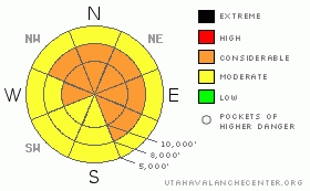
Danger Rose Tutorial
|
Bottom Line for the Salt Lake and Park City mountains:
There remains a CONSIDERABLE (Serious) avalanche danger on any slope above 8,500 feet that faces northwest, north, northeast, east and southeast, approaching 35 degrees, that did not slid during the previous week. You can trigger avalanches from shallower areas and they will propagate into deeper, stronger snow, resulting in large, probably unsurvivable avalanches. Slopes that have slid, face south or are less steep than about 35 degrees have a MODERATE danger. There is also a MODERATE danger on any slope approaching 35 degrees or steeper for new snow slides, especially where the wind has drifted the snow. Don't let the fresh snow skew your judgment. Dangerous conditions still exist, so use careful route finding and travel on terrain less steep than 35 degrees and away from avalanche runout zones. |
|
|
CURRENT CONDITIONS |

|
The cold front that cruised through last night laid down some much needed powder, a fairly even 9” from Ogden down through the Provo mountains, with Little Cottonwood just edging everyone out with 13 inches. Densities are about 7 to 8%. Yesterday's blasting southwesterly winds switched to a more northwesterly direction with frontal passage and dropped into the 10 to 15 mph range, except across the highest peaks. There, wind speeds are still significant, with averages 25 to 35 mph and gusts into 40's. Temperatures have plummeted into the single digits to low teens. |
|
|
RECENT ACTIVITY |

|
Once again, no new avalanches were reported from the backcountry, (or from control work) though much of the lack of activity can be contributed to few people out and about and the widespread avalanche cycle of the past weeks. |
|
|
THREAT #1 |

|
| WHERE |
PROBABILITY |
SIZE |
TREND |
|
|
|
|
| |
|
|
Over the next
24 hours.
|
|
|
My greatest concern for travel in the backcountry today is the possibility of triggering one of the lingering deep slabs. The weak layer combination of fragile faceted snow and a rain crust is buried 3 to 4 feet deep, and any slide triggered on these layers would be large, dangerous and probably deadly. While the snow pack has strengthened, it is still possible for a person to trigger one of these large slides from a thin spot, perhaps mid slope, or even as the 2nd or 4th person on the slope. Although many slopes slid since Christmas, some still hang in the balance. The new and wind blown snow has filled in many of the paths that ran, so it is much harder to tell what has slid, and what has not. The slick rain crust was not taken out in many of the slide paths, and now that they're loaded up with more snow they may be ready to repeat. |
|
|
THREAT #2 |

|
| WHERE |
PROBABILITY |
SIZE |
TREND |
|
|
|
|
| |
|
|
Over the next
24 hours.
|
|
|
The second avalanche problem today is the more predictable and manageable new snow. The new snow is falling on a variety of old snow surfaces, from dense, warm snow and thick crusts to a patches of recrystallized weaker surface snow, with a few odd thin crusts thrown in. In some places, the new snow will bond well to the old snow surfaces, while in other places, especially where wind blown, the new snow will be quite sensitive to the weight of a person. The slopes that have already slid are somewhat safer, but don't let your guard down. Watch for and avoid the soft drifts of the new snow along the ridges, and older hidden hard drifts from yesterday's strong winds. |
|
|
MOUNTAIN WEATHER |

|
The cold front is well to the south of us, leaving snow showers in it's wake. Accumulations for the rest of today are expected to be light, only an inch or two. The northwesterly winds should continue to decrease, with even the highest ridges eventually dropping into the 10 to 20 mph range. Temperatures will struggle to reach low teens at 8,500, and remain in the single digits at 10,000'. Partly cloudy skies and very cold tonight and Sunday, with lows below zero and highs in the single digits to mid teens. The extended forecast calls for a weak storm on Monday and another small storm around next weekend. |
|
|
GENERAL ANNOUNCEMENTS |
Wasatch Powderbird guides did not fly yesterday due to wind and will most likely not fly today for the same reason. Click here to go directly to their operations planning page.
If you want to get this avalanche advisory e-mailed to you daily click HERE.
For a text only version, the link is on the left side bar, near the top.
UDOT highway avalanche control work info can be found by calling (801) 975-4838. Our statewide toll free line is 1-888-999-4019 (early morning, option 8).
The UAC depends on contributions from users like you to support our work. To find out more about how you can support our efforts to continue providing the avalanche forecasting and education that you expect please visit our Friends page.
If you’re getting out and see anything we should know about please let us know. You can leave a message at (801) 524-5304 or 1-800-662-4140, or email us at uac@utahavalanchecenter.org. (Fax 801-524-6301).
This advisory does not apply to ski areas or highways where avalanche control is normally done. The information in this advisory is from the U.S. Forest Service, which is solely responsible for its content. This advisory describes general avalanche conditions and local variations always occur.
Brett Kobernik will update this advisory by 7:30 tomorrow morning. |
|
|
This information does not apply to developed ski areas or highways where avalanche control is normally done. This advisory is from the U.S.D.A. Forest Service, which is solely responsible for its content. This advisory describes general avalanche conditions and local variations always occur. |
|
This advisory provided by the USDA Forest Service, in partnership with:
The Friends of the Utah Avalanche Center, Utah Division of State Parks and Recreation, Utah Division of Emergency Management, Salt Lake County, Salt Lake Unified Fire Authority and the friends of the La Sal Avalanche Center. See our Sponsors Page for a complete list. |
