AVALANCHE WARNING »
Dangerous avalanche conditions are occuring or are imminent.
Backcountry travel in avalanche terrain is not recommended.
|
 |
Notice:
THIS AVALANCHE WARNING IS FOR THE MOUNTAINS OF NORTHERN AND CENTRAL UTAH INCLUDING THE BEAR RIVER RANGE, WESTERN UINTAS, WASATCH, TUSHARS AND MANTI SKYLINE. A POTENT STORM WILL EFFECT THE MOUNTAINS AND OVERLOAD AN EXISTING WEAK SNOWPACK. THIS WILL RESULT IN NATURAL AVALANCHE ACTIVITY. HUMAN TRIGGERED AVALANCHES ARE ALMOST CERTAIN ON MANY HIGH ELEVATION SLOPES. THE UTAH AVALANCHE CENTER IS RECOMMENDING THAT PEOPLE AVOID THE BACKCOUNTRY UNTIL CONDITIONS IMPROVE. THE AVALANCHE DANGER WILL LINGER INTO THE WEEKEND EVEN THOUGH WE MAY SEE SOME CLEARING OF THE WEATHER.
|
|
|
SPECIAL ANNOUNCEMENT |
 |
UDOT in Little Cottonwood will conduct avalanche control work from 6am to around 8am this morning. UDOT in Big Cottonwood expects to do intermittent road closures during the day to do control work. People should avoid the Kessler, Argenta and Stairs Gulch avalanche paths.
|
|
|
BOTTOM LINE
Danger by aspect and elevation on slopes approaching 35° or steeper.
(click HERE for tomorrow's danger rating)
|
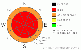
Danger Rose Tutorial
|
The danger remains HIGH this morning and may rise to EXTREME if this storm produces like it could. Human triggered avalanches are a certainty. Natural avalanches are expected. Fresh wind drifts at all elevations could produce avalanches. Backcountry travel is not recommended. The avalanche danger is expected to remain HIGH over the next few days into the weekend.
|
|
|
CURRENT CONDITIONS |

|
It's somewhat of a Christmas tradition here at the Utah Avalanche Center to read the Christmas forecast in verse. This is not appropriate for the current conditions which should be a clue to the severity of things right now. Temperatures are mild this morning in the low to mid 20s. The winds could hardly be categorized that way and are howling pretty good from a southerly direction averaging in the 30s and 40s along the higher ridges and gusting into the 60s and 70s. Only a few inches of snow has accumulated in the Cottonwoods this morning. Sundance has received around 6 inches and it looks like around 4 to 6 inches at Snowbasin overnight.
|
|
|
RECENT ACTIVITY |

|
I regret to inform you of a dual avalanche fatality that happened on the northeast aspect of Logan Peak yesterday. Two young snowmobilers were caught and killed in an avalanche that they triggered which was up to 8 feet deep. Other human triggered avalanches include a large slide in South Monitor 2 feet deep and 300 feet wide that ran around 900 feet vertical. The northeast aspect of 10420 released 2 to 3 feet deep and appears that it was triggered by snowmobilers from below. Skiers on south facing Flagstaff ridge in Little Cottonwood triggered a slide that was around 5 feet deep and 80 feet wide running around 800 feet which sympathetically released another pocket a few hundred feet away. It was all the snow safety team at Snowbasin could do to keep the doors from coming off the hinges yesterday. Other teams continue to pull out large slides with explosives and one team reported a deep natural avalanche that occurred in the mid afternoon on Wednesday. Visibility yesterday allowed views of other natural avalanches that have released recently. On a side note, we've received two reports of fresh wind slabs that released as avalanches at very low elevations. One report came from Wasatch Boulevard and one came from the junction of SR248 and US 40 in Summit County. I have numerous photos to post in the next few hours.
|
|
|
THREAT #1 |

|
| WHERE |
PROBABILITY |
SIZE |
TREND |

|
|
|
|
| |
|
|
Over the next
24
hours.
|
|
|
There's no need to analyze things carefully to make decisions. Back off right now. Avalanches will continue to release naturally as well as with human triggers. These will break into weak snow near the ground producing large avalanches. Some avalanche paths that have released over the last week have reloaded and released again. There's really no way to justify getting onto any steep slope right now. Normally I'd remind people that only one person should be on a slope at a time but right now, no one should be.
|
|
|
THREAT #2 |

|
| WHERE |
PROBABILITY |
SIZE |
TREND |

|
|
|
|
| |
|
|
Over the next
24
hours.
|
|
|
Fresh wind drifts are a secondary issue to the deep releases. You may find these at all elevations today. Visible drifting snow and shooting cracks are the most obvious clues to wind slab formation.
|
|
|
MOUNTAIN WEATHER |

|
We'll see increasing snowfall during the day today favoring areas that do well in a southwesterly flow. I wouldn't be surprised to see a foot or more during the day in the high country. A cold front moves through late afternoon when the flow switches to northwest. A period of heavy snowfall is expected with this. Total water is still looking like it will push 2” which easily translates to 2 feet of total snow. Temperatures will be in the mid twenties today before cooling off with the cold front. Winds will continue to be strong from the southwest during the day and will keep fairly strong speeds with the frontal passage. Temperatures will drop into the single digits overnight and remain cold into Friday with periods of snowfall still possible.
|
|
|
GENERAL ANNOUNCEMENTS |
I'd like to thank White Pine Touring in Park City and AIARE for putting on an avalanche awareness fundraiser in park City for us last night, raising over $2500. Cheers.
If you want to get this avalanche advisory e-mailed to you daily click HERE.
The Wasatch Powderbird Guides - for information, call them at 801-742-2800 or go to their daily blog. Today they'll be doing control work for UDOT and the ski areas and reconning the 'northern powder circuit'.
UDOT highway avalanche control work info can be found by calling (801) 975-4838. Our statewide toll free line is 1-888-999-4019 (early morning, option 8).
The UAC depends on contributions from users like you to support our work. To find out more about how you can support our efforts to continue providing the avalanche forecasting and education that you expect please visit our Friends page.
If you’re getting out and see anything we should know about please let us know. You can leave a message at (801) 524-5304 or 1-800-662-4140, or email us at uac@utahavalanchecenter.org. (Fax 801-524-6301).
The information in this advisory is from the U.S. Forest Service, which is solely responsible for its content. This advisory describes general avalanche conditions and local variations always occur.
Bruce Tremper will update this forecast by 7:30 on Friday morning. |
|
|
This information does not apply to developed ski areas or highways where avalanche control is normally done. This advisory is from the U.S.D.A. Forest Service, which is solely responsible for its content. This advisory describes general avalanche conditions and local variations always occur. |
|
This advisory provided by the USDA Forest Service, in partnership with:
The Friends of the Utah Avalanche Center, Utah Division of State Parks and Recreation, Utah Division of Emergency Management, Salt Lake County, Salt Lake Unified Fire Authority and the friends of the La Sal Avalanche Center. See our Sponsors Page for a complete list. |
