SPECIAL ANNOUNCEMENT |
 |
A SPECIAL AVALANCHE ADVISORY continues for the mountains of northern Utah. Conditions remain very dangerous in the backcountry. Naturals are still possible and large, human triggered avalanches are likely on many slopes.
UDOT in Little Cottonwood will be doing control work from Superior to Grizzly Gulch starting at 6:30 this morning. |
|
|
BOTTOM LINE
Danger by aspect and elevation on slopes approaching 35° or steeper.
(click HERE for tomorrow's danger rating)
|
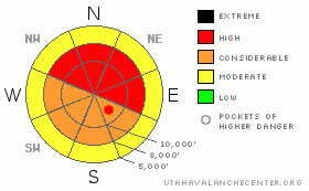
Danger Rose Tutorial
|
The danger remains HIGH in the mid and upper elevations on slopes steeper than 35 degrees. Even many of the low elevation roadcuts have released. Human triggered avalanches are a certainty. Naturals are still possible. Avoid runout zones. Those without years of experience should avoid the backcountry and stick to the ski areas. |
|
|
CURRENT CONDITIONS |

|
Come, let's go
Snow-viewing - Matsuo Basho, Japanese poet in the late 1600's
Till we're buried.
Preferential treatment often goes to the Ogden, Park City, and Provo mountains on a southwest flow-storm track. Water numbers are indeed impressive from yesterday in these areas with 1.5-2” of 'snow-water-equivalent'. The Cottonwoods picked up 12-16” of snow, with many areas receiving, at times, snowfall rates of up to 4”/hr. You can almost hear the rubberband snap at those rates – before getting dusted by an avalanche dustcloud. The southwesterly winds howled at 30-45mph with gusts to 70. Even the lower elevations received the brunt and it was difficult to hide from its fury. With the passing of the cold front, temperatures dropped into the single digits and the westerly winds are now generally less than 15mph. It's still snowing. Most areas picked up another 3-6” overnight of low density champagne. |
|
|
RECENT ACTIVITY |

|
Numerous long running naturals released in some of the steeper starting zones above the Cottonwood and Sundance (SR-92) canyons yesterday during the high snowfall rates and strong winds. Many of them released again overnight. Yesterday a skier along the Park City ridgeline triggered a slide that broke 40' above him, releasing 2-3' deep and 50' wide. He was able to grab a tree and let the snow wash by. It's not over. Then, skiing out to the left, he had another piece of snow break out 100' above him. With the snow coming, he was able to ski into a tree and again hold on as the snow rushed by. He was uninjured, but this very experienced professional said he lost a couple years to his life by the event. Just to the south along, still along the PC ridgeline on something we call 'No-Name', an intentional cornice drop pulled out a hard slab to the ground 3' deep and 50' wide. This, like the others, was on a north to northeast facing slope at 9600'. Most surprising to this experienced skier was that the hard slab pulled back toward the ridge with some parts of the fracture line measuring 15-20 degrees in steepness.
Check out Bruce's you tube video. |
|
|
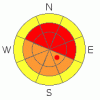
THREAT #1 |

|
| WHERE |
PROBABILITY |
SIZE |
TREND |
|
|
|
|
| |
|
|
Over the next
24 hours.
|
|
|
The wheels are coming off. Remember our old analogy of putting the encyclopedia brittanica on the kitchen table and tilting it up to 40 degrees? It's happening, and as the books are sliding off, you're breaking the legs of the table at the same time. We're seeing naturals on south facing slopes, step down and remotely triggered slides on the shadier aspects, and very experienced workers getting surprised. You'll still be able to trigger 'covered-up' wind slabs, remotely trigger hard slab avalanches, and pull out still-consolidating storm snow avalanches from yesterday. Stick to ridgelines and avoid runout zones. Getting out of the way at the bottom is not the same as it used to be. If you get out of the way, then move under an adjacent avalanche path, the next rider may remotely trigger that slide on top of you. |
|
|
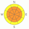
THREAT #2 |

|
| WHERE |
PROBABILITY |
SIZE |
TREND |
|
|
|
|
| |
|
|
Over the next
24 hours.
|
|
|
The second avalanche problem is the lingering instability from yesterday snow and wind. Overnight naturals are clear indications of this issue. |
|
|
MOUNTAIN WEATHER |

|
We'll see off and on snow throughout the day. West to northwest winds will blow 15-20mph then back to the southwest in the late afternoon. Temps will be 5-10 degrees F. The next blockbuster arrives tomorrow into Christmas Day. Up to and over 2' of snow is expected, followed by another storm on the 28th. |
|
|
GENERAL ANNOUNCEMENTS |
If you want to get this avalanche advisory e-mailed to you daily click HERE.
The Wasatch Powderbird Guides - for information, call them at 801-742-2800 or go to their daily blog.
UDOT highway avalanche control work info can be found by calling (801) 975-4838. Our statewide toll free line is 1-888-999-4019 (early morning, option 8).
The UAC depends on contributions from users like you to support our work. To find out more about how you can support our efforts to continue providing the avalanche forecasting and education that you expect please visit our Friends page.
If you’re getting out and see anything we should know about please let us know. You can leave a message at (801) 524-5304 or 1-800-662-4140, or email us at uac@utahavalanchecenter.org. (Fax 801-524-6301).
The information in this advisory is from the U.S. Forest Service, which is solely responsible for its content. This advisory describes general avalanche conditions and local variations always occur.
I will update this forecast by 7:30 on Wednesday morning. |
|
|
This information does not apply to developed ski areas or highways where avalanche control is normally done. This advisory is from the U.S.D.A. Forest Service, which is solely responsible for its content. This advisory describes general avalanche conditions and local variations always occur. |
|
This advisory provided by the USDA Forest Service, in partnership with:
The Friends of the Utah Avalanche Center, Utah Division of State Parks and Recreation, Utah Division of Emergency Management, Salt Lake County, Salt Lake Unified Fire Authority and the friends of the La Sal Avalanche Center. See our Sponsors Page for a complete list. |
