SPECIAL ANNOUNCEMENT |
 |
A SPECIAL AVALANCHE ADVISORY continues for the mountains of northern Utah. In terrain above about 8000 feet that faces west through north through south east, natural avalanches are possible and large, human triggered avalanches are likely on many slopes. |
|
|
BOTTOM LINE
Danger by aspect and elevation on slopes approaching 35° or steeper.
(click HERE for tomorrow's danger rating)
|
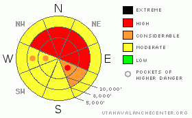
Danger Rose Tutorial
|
A mostly CONSIDERABLE avalanche danger will rise quickly back to HIGH today as new snow and wind further overloads a very fragile, buried weak layer. Avalanches can easily break 2-3 feet deep and quite wide, making very dangerous avalanches. Avoid all slopes steeper than 30 degrees with recent deposits of wind drifted snow and avoid all slopes above 8,500' that face the west, north and east quadrants of the compass. |
|
|
CURRENT CONDITIONS |

|
Yet another storm has arrived in Utah—the same storm that gave Portland, Oregon the most snow since 1967. It is hitting the Ogden area mountains harder than farther south. They have 5 inches of snow with very strong winds, 40, gusting to 70 along the ridges and even stronger winds on the higher peaks. Only an inch has fallen so far in the Cottonwood Canyons. Temperatures are still warm—near 25. |
|
|
RECENT ACTIVITY |

|
We miraculously made it through the weekend without an avalanche fatality. Congratulations, everyone for cooling it on the steep terrain. There were several intentional human triggered avalanches yesterday—all in the thinner snowpack areas that were also heavily wind loaded by Friday's wind. The Park City ridgeline continued to produce excitement. One party kicked cornices along Dutch Draw, near the Canyons resort and triggered a very large avalanche, 2-3 feet deep and at least 200 feet wide, possibly much wider as the crack ran around the corner and they did not look at the rest of it. We've all been waiting for that slope to go. Then another party remotely triggered another avalanche in Alexander Basin, which is in Mill Creek. There was yet another (apparent) recent, natural in the Monitors (Park City ridgeline). A couple snowmobilers intentionally trigered a slide in White Pine, near Park City near the radio communication towers. Control work in uncompacted terrain at the resorts continued to produce class II and occasional class III slides. |
|
|
THREAT #1 |

|
| WHERE |
PROBABILITY |
SIZE |
TREND |
|
|
|
|
| |
|
|
Over the next
24 hours.
|
|
|
The main problem is what we call “persistent” weak layers—namely a couple buried layers of faceted snow on top of and beneath a prominent rain crust. They are called persistent weak layers because they are, well, persistent. They continue to produce avalanches for a long time after they are buried. Patience is the key. But most folks this time of year are like kids who JUST CAN'T WAIT for Santa. And they just have to sneak a peak, rattle a box of even tear into one early. With several large storms on the way, hopefully, we won't have to wait too long for everything to avalanche and we can just start over with much more stable snow. These problems exist mainly above 8,500' on slopes that face the west, north and east quadrants of the compass. |
|
|
THREAT #2 |

|
| WHERE |
PROBABILITY |
SIZE |
TREND |

|
|
|
|
| |
|
|
Over the next
24 hours.
|
|
|
The second avalanche problem today is new snow and wind. I'm expecting about a foot of snow by Tuesday morning—perhaps a foot and a half in the Ogden area mountains, all accompanied by strong, southwest winds, which will drift snow onto the exact same slopes with the aforementioned persistent weak layers. |
|
|
MOUNTAIN WEATHER |

|
About a foot of snow should fall by Tuesday morning with perhaps a foot and a half in the Ogden and Logan area mountains. Ridgetop winds will blow very hard from the southwest this morning as the front approaches, blowing 30-40, gusting into the 60's. Ridge top temperatures will be around 25 this morning and drop quickly to around 15 tonight after the cold front passes. Late this afternoon, the ridge top winds will turn westerly and even northwesterly for a few hours before dying off and turning back to the west and southwest by Tuesday.
If you're like me and love big snowstorms, you'll love the extended forecast. We have a large storm that will arrive with Santa and last for a couple days, then yet another one on about the 28th. |
|
|
GENERAL ANNOUNCEMENTS |
If you want to get this avalanche advisory e-mailed to you daily click HERE.
The Wasatch Powderbird Guides - for information, call them at 801-742-2800 or go to their daily blog.
UDOT highway avalanche control work info can be found by calling (801) 975-4838. Our statewide toll free line is 1-888-999-4019 (early morning, option 8).
The UAC depends on contributions from users like you to support our work. To find out more about how you can support our efforts to continue providing the avalanche forecasting and education that you expect please visit our Friends page.
If you’re getting out and see anything we should know about please let us know. You can leave a message at (801) 524-5304 or 1-800-662-4140, or email us at uac@utahavalanchecenter.org. (Fax 801-524-6301).
The information in this advisory is from the U.S. Forest Service, which is solely responsible for its content. This advisory describes general avalanche conditions and local variations always occur.
Drew Hardesty will update this forecast by 7:30 on Tuesday morning. |
|
|
This information does not apply to developed ski areas or highways where avalanche control is normally done. This advisory is from the U.S.D.A. Forest Service, which is solely responsible for its content. This advisory describes general avalanche conditions and local variations always occur. |
|
This advisory provided by the USDA Forest Service, in partnership with:
The Friends of the Utah Avalanche Center, Utah Division of State Parks and Recreation, Utah Division of Emergency Management, Salt Lake County, Salt Lake Unified Fire Authority and the friends of the La Sal Avalanche Center. See our Sponsors Page for a complete list. |
