AVALANCHE WARNING »
Dangerous avalanche conditions are occuring or are imminent.
Backcountry travel in avalanche terrain is not recommended.
|
 |
Notice:
I have an avalanche warning in effect for the Wasatch Range and the Uinta Mountains. Strong winds and heavy snow will overload buried weak layers in the snowpack, making large and dangerous avalanches.
|
|
|
BOTTOM LINE
Danger by aspect and elevation on slopes approaching 35° or steeper.
(click HERE for tomorrow's danger rating)
|
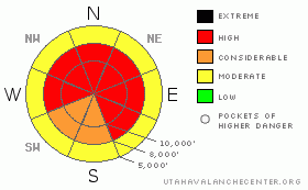
Danger Rose Tutorial
|
A HIGH avalanche danger for all the mountains of northern Utah today and through the weekend on slopes of 30 degrees or steeper, above about 8,000' on slopes that face northwest, north, northeast, east and southeast. Backcountry travelers should avoid all avalanche terrain, including runout areas. There is a CONSIDERABLE danger on other slopes.
|
|
|
CURRENT CONDITIONS |

|
Ridge top winds are blowing hard with hourly averages of 40, gusting to 60 along the highest peaks and 30, gusting to 40 along most of the ridges. Ridge top temperatures are in the teens. There is about a foot of light, fluffy snow, which can easily be blown into drifts. (see 48-hour weather charts)
|
|
|
RECENT ACTIVITY |

|
Although avalanche activity slowed down to a dull roar yesterday, they continued nonetheless with natural avalanches occurring in the Salt Lake and Park City area mountains. One in Scott's Bowl, near Park City in the morning, 9,500', N-NE facing, 1-2.5' deep, An out-of-bounds area in Daily Canyon near Deer Valley at 9,200', NE facing, 1.5-3' deep, 80' wide, an out-of-bounds area at Solitude, lower Hidden Canyon near Brighton, N-NE facing, 1-2' x 80', and yesterday morning, Brighton noticed that more slopes on the back side of Clayton had naturalled wall-to-wall above Lacawaxan Lake, No-No-Name Bowl near Park City, These last two may have occurred on the 17th. There was also a human triggered avalanche in West Monitor yesterday with one person caught but they escaped.
|
|
|
THREAT #1 |

|
| WHERE |
PROBABILITY |
SIZE |
TREND |

|
|
|
|
| |
|
|
Over the next
24 hours.
|
|
|
I'm very worried about today through this weekend and I think it will take a miracle for us to get through the next few days without another avalanche fatality. The snowpack is teetering on the brink right now (see my Youtube video) and today's wind and snow will push much of the snow over the edge. But here is the problem: It probably won't be enough to make everything avalanche and there will still be many slopes hanging in the balance for later this weekend when we have a break between storms. Lingering avalanche potential combined with eager hoards of snow-starved folks is bound to end end badly for someone. Please help spread the word.
Note of caution to the advanced users: avalanches which have run recently may easily reload with snow and slide again, either on top of the rain crust or on the faceted snow beneath the rain crust, both of which were left intact on most recent avalanches.
|
|
|
THREAT #2 |

|
| WHERE |
PROBABILITY |
SIZE |
TREND |

|
|
|
|
| |
|
|
Over the next
24 hours.
|
|
|
As usual, avoid recent deposits of wind drifted snow on steeper slopes. They will look smooth and rounded and often sound hollow or feel hard on top and soft underneath. |
|
|
MOUNTAIN WEATHER |

|
Strong southwest winds are already blowing and they will increase throughout the day until the cold front passes this afternoon. They should average 50 gusting to 70 along the exposed ridges. Snow should begin falling in earnest around noon and we should get 12-20 inches of snow by late on Saturday. Temperatures will plunge down to just below zero after the front passes and we will likely get lake effect squalls on a northwest to westerly flow tonight. Saturday should be continued snow and Sunday looks like partly cloudy with light snow showers.
The extended forecast: This storm will seem like a baby compared to the next couple storms, one on Monday and Tuesday and the other the day after Christmas. We should have feet and feet of new snow by the weekend after Christmas.
|
|
|
GENERAL ANNOUNCEMENTS |
If you want to get this avalanche advisory e-mailed to you daily click HERE.
The Wasatch Powderbird Guides - for information, call them at 801-742-2800 or go to their daily blog.
UDOT highway avalanche control work info can be found by calling (801) 975-4838. Our statewide toll free line is 1-888-999-4019 (early morning, option 8).
The UAC depends on contributions from users like you to support our work. To find out more about how you can support our efforts to continue providing the avalanche forecasting and education that you expect please visit our Friends page.
If you’re getting out and see anything we should know about please let us know. Your information could save someone's life. You can leave a message at (801) 524-5304 or 1-800-662-4140, or email us at uac@utahavalanchecenter.org. (Fax 801-524-6301).
The information in this advisory is from the U.S. Forest Service, which is solely responsible for its content. This advisory describes general avalanche conditions and local variations always occur.
Evelyn Lees will update this forecast by 7:30 on Saturday morning. |
|
|
This information does not apply to developed ski areas or highways where avalanche control is normally done. This advisory is from the U.S.D.A. Forest Service, which is solely responsible for its content. This advisory describes general avalanche conditions and local variations always occur. |
|
This advisory provided by the USDA Forest Service, in partnership with:
The Friends of the Utah Avalanche Center, Utah Division of State Parks and Recreation, Utah Division of Emergency Management, Salt Lake County, Salt Lake Unified Fire Authority and the friends of the La Sal Avalanche Center. See our Sponsors Page for a complete list. |
