AVALANCHE WARNING »
Dangerous avalanche conditions are occuring or are imminent.
Backcountry travel in avalanche terrain is not recommended.
|
 |
Notice: LARGE NATURAL AVALANCHES HAVE OCCURRED AND WILL CONTINUE TO OCCUR IN STEEP TERRAIN AT THE MID AND UPPER ELEVATIONS. HUMAN TRIGGERED AVALANCHES ARE LIKELY AND POTENTIALLY FATAL. THOSE WITHOUT EXCELLENT AVALANCHE SKILLS ARE URGED TO AVOID THE BACKCOUNTRY. |
|
|
BOTTOM LINE
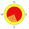
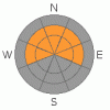
Danger by aspect and elevation on slopes approaching 35° or steeper.
(click HERE for tomorrow's danger rating)
|
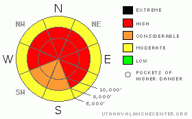
Danger Rose Tutorial
|
The danger is CONSIDERABLE to HIGH. Let's be clear: the backcountry is exceedingly dangerous right now. You will trigger an avalanche if you decide to ski a steep slope at the mid and upper elevations. You will also be able to trigger avalanches at a distance, with some of them pulling back to lower angled slopes. |
|
|
CURRENT CONDITIONS |

|
Instability showers kept piling it up in the Salt Lake, Park City, and Ogden mountains. Totals pushed a foot of alternating smoke and graupel. The moisture tap landed in the Provo mountains, with snow totals reaching 3' of snow in just over 24 hours. See photo. Winds blew from the west southwest for part of the afternoon, but have since calmed to less than 20mph. Temps are back into the single digits. |
|
|
RECENT ACTIVITY |

|
The Provo Mountains shed much of their skin yesterday during the heavy snowfall as many slopes approaching 40 degrees released naturally. UDOT in Provo closed SR-92 to Sundance for some time as even the lower elevation slopes avalanched. Two naturals released yesterday in the Salt Lake mountains: one off the backside of Clayton Peak near Brighton and the other in West Monitor bowl along the Park City Ridgeline – but these pale in comparison to both the skier triggered activity in the backcountry and explosive control work within the ski areas. We had one close call reportedly off the back of Clayton Peak in the Brighton backcountry as a snowmobiler, side-hilling low on the slope, triggered a large slide that buried him partially and his sled completely. Three other significant slides were triggered remotely (west ridge off 10,420' in upper BCC - see Evelyn's excellent gallery/analysis, two in north facing West Bowl of Silver Fork , and another near Pioneer Peak in the Brighton backcountry Many photos have come in - click photos on the bar to your left). Control teams in at least Big Cottonwood and along the Park City ridgeline remotely triggered numerous slides and cleaned out many of their starting zones, initiating full depth slides up to 3-4' deep and 600' wide. Understated, as always, a good friend managing control efforts at one of the ski areas said, 'seems like it was going off.' This was after having produced a mile and a half of crown lines. |
|
|
THREAT #1 |

|
| WHERE |
PROBABILITY |
SIZE |
TREND |
|
|
|
|
| |
|
|
Over the next
24 hours.
|
|
|
These are the conditions that will catch and kill people. No, we are not having a widespread natural cycle. No, we are not seeing more snow and blow. BUT, it is where you and the snowpack intersects on a line of desire and instability that will produce the accident. Let me explain: This is perhaps your mind-set: the riding conditions are excellent and we've been denied by the early season storm tracks, following a 700” inch year. The snow? The snow doesn't care. There are buried land mines everywhere at the mid and upper elevations on many parts of the compass. When collapsing is the rule and remotely triggered avalanches are the rule, and snow safety teams are shaking their heads, talking about 20 year events, then one must pause.
Sure we have various failure planes: strengthening basal depth hoar, weak facet-crust combinations sliding above and below the Thanksgiving rain crust, thin faceted snow from the December 4th storm, but it's academic at this point. If you decide to center punch one of the aforementioned slopes, you may a well flip a coin – one with two heads. Consider yourself lucky if you come out with only injuries. Please help us spread the work. |
|
|
THREAT #2 |

|
| WHERE |
PROBABILITY |
SIZE |
TREND |
|
|
|
|
| |
|
|
Over the next
12 hours.
|
|
|
Adding to the fray now are the soft and hard slabs from yesterday's stronger, punishing southerly winds. These may be just off the ridgelines or further down on the slope. Remember, cracking and collapsing are immediate signs of instability. I'd recommend sticking to the lower angle slopes (meadow skipping) for a while. |
|
|
MOUNTAIN WEATHER |

|
We'll have mostly clear skies. Winds will be 15-20 form the west and temps will be in the single digits to lowest teens. Another powerful storm will impact the southern Wasatch tonight into tomorrow, with another storm to even the score Thursday night into Friday and Saturday. The storms are lined up. |
|
|
GENERAL ANNOUNCEMENTS |
The Wasatch Powderbird Guides are likely to recon Silver Days Cardiff, Grizzly and American Fork if the weather permits. They may also do one private lift in the afternoon. For more info, call them at 801-742-2800 or go to their daily blog.
If you want to get this avalanche advisory e-mailed to you daily click HERE.
UDOT highway avalanche control work info can be found by calling (801) 975-4838. Our statewide toll free line is 1-888-999-4019 (early morning, option 8).
The UAC depends on contributions from users like you to support our work. To find out more about how you can support our efforts to continue providing the avalanche forecasting and education that you expect please visit our Friends page.
If you’re getting out and see anything we should know about please let us know. You can leave a message at (801) 524-5304 or 1-800-662-4140, or email us at uac@utahavalanchecenter.org. (Fax 801-524-6301).
The information in this advisory is from the U.S. Forest Service, which is solely responsible for its content. This advisory describes general avalanche conditions and local variations always occur.
I will update this forecast by 7:30 on Wednesday morning. |
|
|
This information does not apply to developed ski areas or highways where avalanche control is normally done. This advisory is from the U.S.D.A. Forest Service, which is solely responsible for its content. This advisory describes general avalanche conditions and local variations always occur. |
|
This advisory provided by the USDA Forest Service, in partnership with:
The Friends of the Utah Avalanche Center, Utah Division of State Parks and Recreation, Utah Division of Emergency Management, Salt Lake County, Salt Lake Unified Fire Authority and the friends of the La Sal Avalanche Center. See our Sponsors Page for a complete list. |
