SPECIAL ANNOUNCEMENT |
 |
If you plan on touring along the Park City ridgeline, be advised that the Canyons Ski Patrol plans to do control work in the McDonald Draw area ths morning. |
|
|
BOTTOM LINE
Danger by aspect and elevation on slopes approaching 35° or steeper.
(click HERE for tomorrow's danger rating)
|
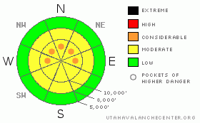
Danger Rose Tutorial
|
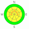
The danger is MODERATE with pockets of CONSIDERABLE danger on most mid and upper elevation west through north through east facing slopes. The danger may be more pronounced in the wind loaded areas of the immediate periphery of the Cottonwood Canyons, to include the Mill Creek and Park City ridgeline. Human triggered avalanches are probable, and may still be triggered at a distance. These are unusual circumstances and avalanche conditions, with even the most savvy backcountry skiers and professionals on edge. It's worth giving that steep line another look, then moving on to something more manageable. |
|
|
CURRENT CONDITIONS |

|
wind jacked, adj. 1. Of, or relating to, being hammered by the wind, often used to describe wind damaged snow surface conditions. 2. The current state of our riding conditions in nearly all but the most protected areas. The southeasterly and southerly winds tore through the landscape yesterday, blowing 20-35mph, gusting to near 50, accentuating the wind chill with temperatures already low in the single digits. Most of the snowfall tracked through the southern Wasatch overnight, with the Provo mountains picking up 21” (YES, 21 inches, of new. Areas north of Timpanogos divide uniformly received 2-3” of snow. Nonetheless, it would be complimentary to describe the riding conditions as wind jacked, threadbare, and dangerous. And not necessarily in that order. |
|
|
RECENT ACTIVITY |

|
By our count, we've had 12 avalanches triggered in the backcountry over the past three days, with about half of those unintentionally triggered. Yesterday, Grant and I went to investigate the accident from the day before that occurred near Squaretop in the Canyons backcountry. The skier triggered the soft slab about a foot deep and 75' wide, taking the Thanksgiving rain crust with him. He was lucky to have been pinned against a tree, avoiding a potential burial, and escaped with a broken pelvis and fractured lower vertebrae. Grant put together an excellent report which should be posted off our accidents and photos page in the next couple of hours.
Enroute the investigation, we saw that a 1' deep and 40' wide soft slab had released naturally on Squaretop from the strong southerly winds. Prudently, we stayed on the safe descent ridge, collapsing the snow the whole way. From other's reports, collapsing of the various weaknesses associated with the buried rain crust, is now nearly the rule and not the exception. And along one of the upper starting zones in Hidden Canyon, in the Brighton backcountry, a skier triggered a 1' deep and 30' wide soft slab breaking on faceted snow a few inches above the crust. This was on a steep northwest facing slope at around 10,100'. |
|
|
THREAT #1 |

|
| WHERE |
PROBABILITY |
SIZE |
TREND |
|
|
|
|
| |
|
|
Over the next
24 hours.
|
|
|
I would like it more if we just had a blockbuster storm with plenty of snow and blow and just be done with it. This would produce a widespread natural and human triggered avalanche cycle and then maybe, maybe we could start again. Instead, we're seeing snow and wind in just drips and drabs, making it locally unstable here, but where you might be able to get away with it there. It's too much. The snowpack is thin, weak, fraught with multiple failure planes and issues. Most of the hullaballoo surrounds the weak faceted snow above and below the rain crust, but a fair amount of the activity over the past couple of days has initiated a few inches above in some thin faceted snow, only to collapse the crust and step into the older weak, faceted snow. |
|
|
THREAT #2 |

|
| WHERE |
PROBABILITY |
SIZE |
TREND |
|
|
|
|
| |
|
|
Over the next
12 hours.
|
|
|
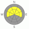
Adding to the fray now are the soft and hard slabs from yesterday's stronger, punishing southerly winds. These may be just off the ridgelines or further down on the slope. Remember, cracking and collapsing are immediate signs of instability. I'd recommend sticking to the lower angle slopes (meadow skipping) for a while. |
|
|
MOUNTAIN WEATHER |

|
We'll see snow and snow showers for much of the day, but it shouldn't produce more than a few inches. The southwesterly winds are expected to relax some as they veer to the west, averaging speeds in the 15-20mph range. Temps will remain cool at 11 degrees at 10,000' and the mid to upper teens at 8000'. Looks like we'll have a quick break in the action tomorrow ahead of what may be a good producer for the southern Wasatch Wednesday night into Thursday. Cold arctic air crashes into Utah for the weekend, dropping temps to -8F in the mountains. |
|
|
GENERAL ANNOUNCEMENTS |
If you want to get this avalanche advisory e-mailed to you daily click HERE.
UDOT highway avalanche control work info can be found by calling (801) 975-4838. Our statewide toll free line is 1-888-999-4019 (early morning, option 8).
The UAC depends on contributions from users like you to support our work. To find out more about how you can support our efforts to continue providing the avalanche forecasting and education that you expect please visit our Friends page.
If you’re getting out and see anything we should know about please let us know. You can leave a message at (801) 524-5304 or 1-800-662-4140, or email us at uac@utahavalanchecenter.org. (Fax 801-524-6301).
The information in this advisory is from the U.S. Forest Service, which is solely responsible for its content. This advisory describes general avalanche conditions and local variations always occur.
I will update this forecast by 7:30 on Wednesday morning. |
|
|
This information does not apply to developed ski areas or highways where avalanche control is normally done. This advisory is from the U.S.D.A. Forest Service, which is solely responsible for its content. This advisory describes general avalanche conditions and local variations always occur. |
|
This advisory provided by the USDA Forest Service, in partnership with:
The Friends of the Utah Avalanche Center, Utah Division of State Parks and Recreation, Utah Division of Emergency Management, Salt Lake County, Salt Lake Unified Fire Authority and the friends of the La Sal Avalanche Center. See our Sponsors Page for a complete list. |
