BOTTOM LINE
Danger by aspect and elevation on slopes approaching 35° or steeper.
(click HERE for tomorrow's danger rating)
|
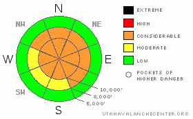
Danger Rose Tutorial
|
Bottom Line for the Salt Lake and Park City area mountains:
Dangerous avalanche conditions exist in the mid and upper elevations of the Wasatch mountains - as the snow piles up and the winds continue to blow, the avalanche danger will rapidly rise to CONSIDERABLE on steep, wind drifted slopes. On mid and upper elevation northwest through southeasterly facing slopes, it will be possible to trigger slides on the old snow weak layers from a distance and any new snow slides may break down into these deeper weak layers, resulting in larger and more dangerous avalanches. If you head into the backcountry today, use conservative decision making, careful route finding and good travel habits. Training and experience are essential for backcountry travel today. Below about 8,000', where the new snow is falling on bare ground, the avalanche danger is generally LOW. |
|
|
CURRENT CONDITIONS |

|
The cold front is racing across the Great Salt Lake, and is forecast to reach the northern Wasatch mountains between 8 and 10 am. Ahead of the front, strong southwesterly winds have been tearing across the range, with 30 to 50 mph averages, and gusts in the 40 to 60 mph range. Even in more sheltered locations and at lower elevations, gusts are in the 20's and 30's. Pre-frontal precipitation on the southwesterly flow is in the 3 to 6” range. Temperatures started to drop after midnight, and are currently near 20 at 10,000'. |
|
|
RECENT ACTIVITY |

|
No new avalanche activity was reported from the backcountry or the resorts yesterday, however, the avalanche danger is increasing today. I expect new snow and wind slab avalanche activity, with the possibility of slides breaking down into the deeper weak layers. |
|
|
THREAT #1 |

|
| WHERE |
PROBABILITY |
SIZE |
TREND |

|
|
|
|
| |
|
|
Over the next
24 hours.
|
|
|
The most widespread avalanche activity today will be within the new storm snow and the fresh wind drifts. Winds will blow today's new snow into sensitive drifts 2 to 3 feet deep, that will easily be triggered by people on steep slopes. The drifts will be most widespread on northeast through southeasterly facing slopes, but watch for cross loading around terrain features such as gully walls and subridges. Once the snow starts moving, there is the potential for slides to run further and faster if the moving snow breaks down and runs on the slick ice crusts. Expect natural avalanche activity to increase during periods with high precipitation rates, when it's snowing 2 to 4 inches per hour. |
|
|
THREAT #2 |

|
| WHERE |
PROBABILITY |
SIZE |
TREND |

|
|
|
|
| |
|
|
Over the next
24 hours.
|
|
|
Further complicating the stability picture, almost anywhere there was old snow, there are sandwiches of weak facets and crusts. These more deeply buried weak layers of loose, sugary crystals are most widespread on the mid and upper elevation northwest through southeasterly facing slopes, and vary widely from slope to slope. Today's new snow load may be enough to activate some of these more deeply buried weak layers. These are dangerous weak layers, because it will be possible to trigger slides remotely, from a distance. Today, avoid travel both on, below and adjacent to steep slopes with old snow. Stay on low angle terrain, and out from below steep slopes. |
|
|
MOUNTAIN WEATHER |

|
Full conditions today... the National Weather Service has issued a Winter Storm Warning that will remain in effect until 5 pm Sunday, with heavy snow and strong northerly winds creating wild winter conditions. Snow totals of a foot or more expected by 5 pm, with lightning and intense precipitation rates of 2 to 4 inches per hour possible around frontal passage. The winds will shift to the northwest this morning, and remain in the 20 to 30 mph range, with gusts to 50 at the 10,000' level. Gusts to 70 mph are possible across the highest peaks. Temperatures will fall throughout the day, into the low teens to single digits by evening. Periods of snow tonight, with storm totals of 16 to 24” by Sunday afternoon, with temperatures near zero. A cold and unsettled pattern, with more snow, will continue through much of next week. |
|
|
GENERAL ANNOUNCEMENTS |
If you want to get this avalanche advisory e-mailed to you daily click HERE.
UDOT highway avalanche control work info can be found by calling (801) 975-4838. Our statewide toll free line is 1-888-999-4019 (early morning, option 8).
The UAC depends on contributions from users like you to support our work. To find out more about how you can support our efforts to continue providing the avalanche forecasting and education that you expect please visit our Friends page.
If you’re getting out and see anything we should know about please let us know. You can leave a message at (801) 524-5304 or 1-800-662-4140, or email us at uac@utahavalanchecenter.org. (Fax 801-524-6301).
The information in this advisory is from the U.S. Forest Service, which is solely responsible for its content. This advisory describes general avalanche conditions and local variations always occur.
Brett Kobernik will update this forecast by 7:30 on Sunday morning. |
|
|
This information does not apply to developed ski areas or highways where avalanche control is normally done. This advisory is from the U.S.D.A. Forest Service, which is solely responsible for its content. This advisory describes general avalanche conditions and local variations always occur. |
|
This advisory provided by the USDA Forest Service, in partnership with:
The Friends of the Utah Avalanche Center, Utah Division of State Parks and Recreation, Utah Division of Emergency Management, Salt Lake County, Salt Lake Unified Fire Authority and the friends of the La Sal Avalanche Center. See our Sponsors Page for a complete list. |
