SPECIAL ANNOUNCEMENT |
 |
Today, UDOT in Provo Canyon will be sighting in their howitzer for their targets, leading to intermittent closures of the road from 10am to 1130am.
Tomorrow....on Thursday December 11, 2008 UDOT will be test firing the Pink Pine Ridge Howitzer in the mid-canyon area. Beginning at 10:30 a.m. traffic will be blocked intermittently (5-10 minutes at a time) from the White Pine Trail Head Parking Lot to the entry to the Tanners Camp Ground. This exercise should be completed by 11:30 a.m. |
|
|
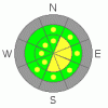
BOTTOM LINE
Danger by aspect and elevation on slopes approaching 35° or steeper.
(click HERE for tomorrow's danger rating)
|

Danger Rose Tutorial
|
Bottom Line for the Salt Lake mountains:
The danger is a localized MODERATE danger for wind slabs along the upper elevation wind drifted slopes. These will be most pronounced in slopes facing northeast through east through south above about 9500'. A pockety MODERATE danger exists for slides stepping into old snow. This terrain is likely relegated to northwest through north through east facing slopes at the mid and upper elevations. A few simple hand snow pits will reveal this suspect layering. Collapsing of the structure is also an indicator of the instability. This will undoubtedly become much more of an issue with the upcoming storms.
Bottom Line for the Ogden, Park City and Provo area mountains: There is a localized MODERATE danger in the uppermost areas for shallow wind drifted snow. These drifts may approach 8-10” deep and will more likely be found on northeast through southeast through south facing slopes.The crust in these outlying areas appear to be significantly more bomb-proof. |
|
|
CURRENT CONDITIONS |

|
After yesterday's crystalline bluebird high, skies are now mostly cloudy to overcast with the passing of a weak storm to the north. Under a rebuilt ridge, temperatures in the high country have warmed dramatically over the past 24 hours and are, in some cases 20 degrees warmer than this time yesterday. Ridgetop temps are now in the mid to upper twenties, with cooler air in the basins and drainages. The northwesterly winds remain vigorous along the most exposed peaks, blowing 20-25mph with 11,000' winds averaging 40 mph with gusts to 60. Riding conditions are improved from Monday's event, though it's still worth exercising caution with the many thinly-veiled rocks and stumps checkering your favorite run. |
|
|
RECENT ACTIVITY |

|
Folks found decidedly less sensitivity in the new snow yesterday, though the ski area teams still were able to move some snow with explosives and slope cuts. Of significant interest is a slide triggered yesterday on a steep north facing slope at 9200', likely along the Park City or Mill Creek ridgeline. A backcountry skier remotely triggered a slide into old snow, collapsing the November 29 rain crust on the weak faceted snow underneath. It ripped out 70' away from him, pulling out 10” deep and 70' wide, running 200'. Control teams along the Park City ridgeline are also getting slides to collapse the rain crust and pull out into the older faceted snow beneath.
They appear to be the exceptions and not the rule now, but with storms lined up for this weekend and beyond, these are, I believe, a portent of things to come. |
|
|
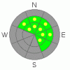
THREAT #1 |

|
| WHERE |
PROBABILITY |
SIZE |
TREND |
|
|
|
|
| |
|
|
Over the next
24 hours.
|
|
|
The stronger winds aloft are peppering many of the steep upper elevation east through south facing starting zones with dense, wind packed snow that may release upon skier or rider impact. Take time to notice the little things out there from day to day. This starts to produce this (notice the rounded, scalloped snow deposits). Ed LaChapelle, Alta snow ranger from 1952-1967, wrote a nice book a few years before his death called Secrets of the Snow. It's worth checking out. In the mean time, avoid any of these freshly scalloped and loaded lee slopes, approach cornices with caution, and tiptoe around in the steep northerly slopes. |
|
|
THREAT #2 |

|
| WHERE |
PROBABILITY |
SIZE |
TREND |
|
|
|
|
| |
|
|
Over the next
24 hours.
|
|
|
The current snow structure is varied and tricky. I did not believe that we had received enough new snow on Monday, particularly outside of the highest reaches of the Cottonwoods. Apparently I was wrong. It would be worth taking another step back. |
|
|
MOUNTAIN WEATHER |

|
We'll see diminishing cloud cover and warm temps in the hills. 8000' and 10k temps will reach to the low to mid-30's today with gradually slowing northwesterly winds. We're likely to see a few inches out of a quick storm early Friday ahead of the all-out regime change in the overall weather pattern. It's about time. Strong, strong pre-frontal winds kick in Friday night ahead of Saturday morning's cold front. The storms appear to be stacked up. |
|
|
GENERAL ANNOUNCEMENTS |
If you want to get this avalanche advisory e-mailed to you daily click HERE.
For a Text-only advisory, click here.
UDOT highway avalanche control work info can be found by calling (801) 975-4838. Our statewide toll free line is 1-888-999-4019 (early morning, option 8).
The UAC depends on contributions from users like you to support our work. To find out more about how you can support our efforts to continue providing the avalanche forecasting and education that you expect please visit our Friends page.
If you’re getting out and see anything we should know about please let us know. You can leave a message at (801) 524-5304 or 1-800-662-4140, or email us at uac@utahavalanchecenter.org. (Fax 801-524-6301).
Evelyn Lees will update this advisory by 7:30am tomorrow. |
|
|
This information does not apply to developed ski areas or highways where avalanche control is normally done. This advisory is from the U.S.D.A. Forest Service, which is solely responsible for its content. This advisory describes general avalanche conditions and local variations always occur. |
|
This advisory provided by the USDA Forest Service, in partnership with:
The Friends of the Utah Avalanche Center, Utah Division of State Parks and Recreation, Utah Division of Emergency Management, Salt Lake County, Salt Lake Unified Fire Authority and the friends of the La Sal Avalanche Center. See our Sponsors Page for a complete list. |
