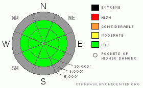
BOTTOM LINE
Danger by aspect and elevation on slopes approaching 35° or steeper.
(click HERE for tomorrow's danger rating)
|
Danger Rose Tutorial
|
The avalanche danger is generally LOW with pocket of new snow sluffing on the steep slopes and wind may create some isolated wind slabs along the upper elevation ridges. |
|
|
CURRENT CONDITIONS |

|
With 5 inches of very fluffy, new snow covering the breakable rain crust, turning conditions have improved to the point that you can actually make turns instead of zig-zags, but the crust still trips you up in places. Coverage is still bony and even with a careful choice of slopes and trails, you tend to bang up your equipment, so keep your Christmas presents in the garage for now and use your Christmas presents from 5 years ago. Today should be a good day to get out with mostly clear weather. |
|
|
RECENT ACTIVITY |

|
The only activity others and myself found yesterday was sluffing of the very light, new snow on the hard ice crust on steep slopes. |
|
|
THREAT #1 |

|
| WHERE |
PROBABILITY |
SIZE |
TREND |

|
|
|
|
| |
|
|
Over the next
24 hours.
|
|
|
The snowpack is very scary. It's scary today because of the multitude of hidden rocks to break your bones and smash your head. It's scary for avalanches with the future in mind. Although everything is quite stable today, with the exception of sluffing of new snow on the steep, rain crusts and localized wind slabs, our next significant storm is sure to produce some tricky avalanches.
With 3-5 inches of very weak snow on the surface, a breakable rain crust below that, and some extremely weak, faceted snow beneath the rain crust, it adds up to a nasty weak layer for future storms. Check out my YouTube video of fieldwork yesterday and Doug Wewer's great photos from the Ogden area mountains. |
|
|
MOUNTAIN WEATHER |

|
Skies will be mostly sunny to partly cloudy today with temperatures near 30 today and warming to near 40 on Saturday. Ridge top winds will blow 10-15 from the northwest and be very light on Saturday. I love the National Weather Service graphs. We will have a high pressure building in for the weekend with warm, sunny weather, but we have a storm on Monday, which has the potential to bring us 6-12 inches of new snow, which may make avalanche conditions interesting.
For the extended forecast, other than Monday's storm, we don't see any significant snow for the next week or so. The long range models continue to hint that the Hudson Bay low will dissipate in about a week, leaving the door open for storms to make it into Utah. |
|
|
GENERAL ANNOUNCEMENTS |
If you want to get this avalanche advisory e-mailed to you daily click HERE.
For a TEXT-only version, click here.
UDOT highway avalanche control work info can be found by calling (801) 975-4838. Our statewide toll free line is 1-888-999-4019 (early morning, option 8).
The UAC depends on contributions from users like you to support our work. To find out more about how you can support our efforts to continue providing the avalanche forecasting and education that you expect please visitour Friends page.
If you’re getting out and see anything we should know about please let us know. You can leave a message at (801) 524-5304 or 1-800-662-4140, or email us at uac@utahavalanchecenter.org. (Fax 801-524-6301).
Evelyn Lees will update this forecast by 7:30 on Saturday morning. |
|
|
This information does not apply to developed ski areas or highways where avalanche control is normally done. This advisory is from the U.S.D.A. Forest Service, which is solely responsible for its content. This advisory describes general avalanche conditions and local variations always occur. |
|
This advisory provided by the USDA Forest Service, in partnership with:
The Friends of the Utah Avalanche Center, Utah Division of State Parks and Recreation, Utah Division of Emergency Management, Salt Lake County, Salt Lake Unified Fire Authority and the friends of the La Sal Avalanche Center. See our Sponsors Page for a complete list. |
