Salt Lake Avalanche Advisory

Forecaster: Brett Kobernik

BOTTOM LINE

Danger by aspect and elevation on slopes approaching 35° or steeper.
(click HERE for tomorrow's danger rating)


Danger Rose Tutorial

Most areas in the Wasatch have a generally LOW danger today. However, there is a "pockety" MODERATE danger in areas where the wind is transporting snow into fresh drifts. This is mainly along upper elevation ridges and more pronounced on the lee side.


CURRENT CONDITIONS

Temperatures are very mild this morning with numerous stations below 9000 feet in the low to mid 30s and mid to upper 20s around 10,000 feet. West northwest winds continue to blow averaging 10 to 20 along the ridgetops gusting into the 40s along the highest terrain features. A few more inches of snow fell in the Cottonwoods along with a misting rain/rime event.


RECENT ACTIVITY

No avalanche activity was reported from Saturday. Our thin snowpack has a plethora of crusts and weakness that don't seem ideal if we start getting any significant snowfall. Monitoring these layers will be crucial in the future.


THREAT #1

WHERE PROBABILITY SIZE TREND
      Over the next 24 hours.

While it is hard to find any significant avalanche activity in most areas, with the continued winds and small amount of new snow, I'd still be on the lookout for small pockets that may release with the weight of a person. These are most likely present along the lee sides of the upper elevation ridges.


MOUNTAIN WEATHER

A northwesterly flow remains in place today but moisture should subside as the ridge of high pressure moves into our area. Seasonably mild temperatures will be in the upper 30s at 8000 feet and around 30 at 10,000. Winds will continue to be a bit gusty in the 10 to 20 mph range along the ridges and gusting into the 40s at the more exposed locations. Temperatures get quite warm on Monday as the ridge will be directly over us. The 700mb level goes to +3 or +4C which translates to the mid 30s at 10,000 feet. A trof and associated cold front move through on Tuesday bringing the next chance for snow.


GENERAL ANNOUNCEMENTS

We'll do daily morning forecast through out the holiday weekend.

Check out upcoming events such as free avalanche talks and fundraisers on our CALENDAR.

If you want to get this avalanche advisory e-mailed to you daily click HERE.

For a text only version of this advisory click HERE.

UDOT highway avalanche control work info can be found by calling (801) 975-4838. Our statewide toll free line is 1-888-999-4019 (early morning, option 8).

The UAC depends on contributions from users like you to support our work. To find out more about how you can support our efforts to continue providing the avalanche forecasting and education that you expect please visitour Friends page.

If you’re getting out and see anything we should know about please let us know. You can leave a message at (801) 524-5304 or 1-800-662-4140, or email us at uac@utahavalanchecenter.org. (Fax 801-524-6301).

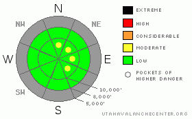
The information in this advisory is from the U.S. Forest Service, which is solely responsible for its content. This advisory describes general avalanche conditions and local variations always occur.


This information does not apply to developed ski areas or highways where avalanche control is normally done.  This advisory is from the U.S.D.A. Forest Service, which is solely responsible for its content. This advisory describes general avalanche conditions and local variations always occur.


This advisory provided by the USDA Forest Service, in partnership with:

The Friends of the Utah Avalanche Center, Utah Division of State Parks and Recreation, Utah Division of Emergency Management, Salt Lake County, Salt Lake Unified Fire Authority and the friends of the La Sal Avalanche Center. See our Sponsors Page for a complete list.