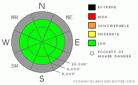
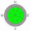
BOTTOM LINE
Danger by aspect and elevation on slopes approaching 35° or steeper.
(click HERE for tomorrow's danger rating)
|
Danger Rose Tutorial
|
The snow in the Wasatch mountains is generally stable and the avalanche danger is Low. |
|
|
CURRENT CONDITIONS |

|
Skies are cloudy this morning, and scattered snow showers have dropped a trace to an ½ inch of snow in the mountains. Temperatures this morning are in the low to mid thirties at most elevations, with a few 20's in the highest terrain. The southeasterly winds are quite light, with all mountain stations less than 15 mph.
The shallow snowpack has the typical early season variability. There's an unusually good selection of supportable to breakable crusts – from shiny rain to fragile mist to strong sun crusts. Mixed in on the shady slopes are growing patches of soft, recrystallized snow. With the right attitude, there's definitely enough snow for a pleasant walk on skies or snowshoes, and even some fun turns are available in select locations. Start and finish your tours at the higher elevations to stay on snow, and remember, with the very shallow snowpack, watch out for hitting stumps and rocks. |
|
|
RECENT ACTIVITY |

|
No avalanche activity has been reported from the backcountry or the resorts for the past several days. |
|
|
THREAT #1 |

|
| WHERE |
PROBABILITY |
SIZE |
TREND |
|
|
|
|
| |
|
|
Over the next
24 hours.
|
|
|
It doesn't have to snow for the snowpack to be interesting. Two weeks of clear nights combined with a shallow snowpack, and the snow is steadily recrystallizing into facets in most locations. In the shallowest areas, it's sandbox snow, with pole basket to the ground. In areas capped with one or more crusts, the facets are developing beneath the crusts. These sugary, weak facets aren't dangerous today, but they have potential to be a nasty weak layer once we get more snow. |
|
|
MOUNTAIN WEATHER |

|
While the southern Utah mountains will get a decent shot of snow out of this storm, it's a nonevent for the northern mountains. Skies will be mostly cloudy today, with a few flurries dusting the crusts with a trace to an inch of snow. Temperatures will be in the mid 30's at 8,000' and the upper 20's at 10,000'. Winds will slowly shift from the southeast to the northeast, and remain light, with speeds less than 15 mph. Mostly cloudy skies tonight, with another slight chance of light snow showers by morning. A northwesterly wind event Friday night could stir things up a bit, with gusts into the 60's across the ridge tops. |
|
|
GENERAL ANNOUNCEMENTS |
We'll do daily morning forecasts through out the holiday weekend.
If you want to get this avalanche advisory e-mailed to you daily click HERE.
UDOT highway avalanche control work info can be found by calling (801) 975-4838. Our statewide toll free line is 1-888-999-4019 (early morning, option 8).
The UAC depends on contributions from users like you to support our work. To find out more about how you can support our efforts to continue providing the avalanche forecasting and education that you expect please visitour Friends page.
If you’re getting out and see anything we should know about please let us know. You can leave a message at (801) 524-5304 or 1-800-662-4140, or email us at uac@utahavalanchecenter.org. (Fax 801-524-6301).
The information in this advisory is from the U.S. Forest Service, which is solely responsible for its content. This advisory describes general avalanche conditions and local variations always occur. |
|
|
This information does not apply to developed ski areas or highways where avalanche control is normally done. This advisory is from the U.S.D.A. Forest Service, which is solely responsible for its content. This advisory describes general avalanche conditions and local variations always occur. |
|
This advisory provided by the USDA Forest Service, in partnership with:
The Friends of the Utah Avalanche Center, Utah Division of State Parks and Recreation, Utah Division of Emergency Management, Salt Lake County, Salt Lake Unified Fire Authority and the friends of the La Sal Avalanche Center. See our Sponsors Page for a complete list. |
