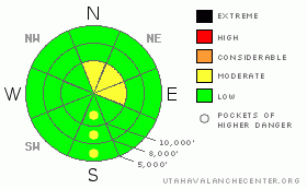
BOTTOM LINE
Danger by aspect and elevation on slopes approaching 35° or steeper.
(click HERE for tomorrow's danger rating)
|

Danger Rose Tutorial
|
The avalanche danger is MODERATE on slopes approaching 35 degrees or steeper with old drifts of wind blown snow, which you will find mostly above 10,000’ on steep north through east facing slopes. It’s also moderate on some steep, sun exposed slopes that are getting soggy in the heat of the afternoon. |
|
|
CURRENT CONDITIONS |

|
If you try hard enough, you can just pretend that it’s late spring after a lean snow year. Just ignore the low angle of the sun, the short days and the Thanksgiving trappings in the grocery store.
Daytime temperatures at 8,000’ are nearly into the bikini range, in the mid 50’s. With the clear skies, the overnight lows have been plunging back down into the down coat range in the mid 20’s in the canyon bottoms and the low 30’s higher up on the slopes where you are above the inversion. The snow on the south facing slopes is getting wet and soggy during the day with lots of firnspiegel—that shiny, thin coat of ice on the surface with mush underneath. Unless you are in Little Cottonwood Canyon, there isn’t much snow left on the south facing slopes, and even in LCC, there is only about a foot left. On the north facing slopes, there’s still about 2 feet of dry, dense, crusty and tricky snow with about half that amount outside of Little Cottonwood Canyon. The Ogden and Provo area mountains have very little snow.
|
|
|
RECENT ACTIVITY |

|
Yesterday, avalanche control work with explosives in upper Little Cottonwood Canyon produced some surprising hard slabs about a foot deep, but quite widespread, with several around 100 feet wide. These were on the highest elevation, north facing slopes, around 10,500’ to 11,000’, where the very strong winds on Thursday night created some hard wind slabs along the high ridges. They thought these were sliding on a buried layer of surface hoar or faceted snow.
|
|
|
THREAT #1 |

|
| WHERE |
PROBABILITY |
SIZE |
TREND |

|
|
|
|
| |
|
|
Over the next
24
hours.
|
|
|
There may be more of these hard slabs lurking but I would suspect that they are at quite high elevations on the shady slopes—probably above 10,000’ on the north through east facing slopes. They will be tricky because they tend to feel solid and reliable until the whole slope shatters like glass. Be sure to check the out carefully. |
|
|
THREAT #2 |

|
| WHERE |
PROBABILITY |
SIZE |
TREND |

|
|
|
|
| |
|
|
Over the next
24
hours.
|
|
|
The second, less dangerous, avalanche problem is the wet and soggy snow on the steep, sun exposed slopes as they get very warm in the heat of the day. As usual, watch for wet sluffs on steep slopes that could take you over a cliff or into a terrain trap. |
|
|
MOUNTAIN WEATHER |

|
What you see is what you will get for the rest of the week. Very warm temperatures with a strong temperature inversion. The daytime highs at 8,000’ will rise into the mid 50’s each afternoon and then plunge into the mid to upper 20’s each night—getting colder in the mountain valley bottoms than higher on the slopes because of the still air and the strong temperature inversions.
The extended forecast calls for some hint of some clouds by the weekend and possibly enough of a cold front to clear out the smog, but probably not much more. We don’t see any significant snow in the forecast for the foreseeable future, which is about 10 days.
|
|
|
GENERAL ANNOUNCEMENTS |
If you want to get this avalanche advisory e-mailed to you daily click HERE.
UDOT highway avalanche control work info can be found by calling (801) 975-4838.
Our statewide toll free line is 1-888-999-4019 (early morning, option 8).
The UAC depends on contributions from users like you to support our work. To find out more about how you can support our efforts to continue providing the avalanche forecasting and education that you expect please visitour Friends page.
If you’re getting out and see anything we should know about please let us know. You can leave a message at (801) 524-5304 or 1-800-662-4140, or email us at uac@utahavalanchecenter.org. (Fax 801-524-6301)
This advisory will only be updated as conditions change.
|
|
|
This information does not apply to developed ski areas or highways where avalanche control is normally done. This advisory is from the U.S.D.A. Forest Service, which is solely responsible for its content. This advisory describes general avalanche conditions and local variations always occur. |
|
This advisory provided by the USDA Forest Service, in partnership with:
The Friends of the Utah Avalanche Center, Utah Division of State Parks and Recreation, Utah Division of Emergency Management, Salt Lake County, Salt Lake Unified Fire Authority and the friends of the La Sal Avalanche Center. See our Sponsors Page for a complete list. |


